
Woods Hole Science Center
Sea-Floor Character and Sedimentary Processes in the Vicinity of Woods Hole, Massachusetts
![]() Title | Abstract | Introduction | Setting | Methods | Bathymetry and Backscatter | Seismic Profiles | Character and Processes | Data Catalog | Acknowledgments | References | Figures | Bottom Photography | Sediment Data | Contacts
Title | Abstract | Introduction | Setting | Methods | Bathymetry and Backscatter | Seismic Profiles | Character and Processes | Data Catalog | Acknowledgments | References | Figures | Bottom Photography | Sediment Data | Contacts
 |
||
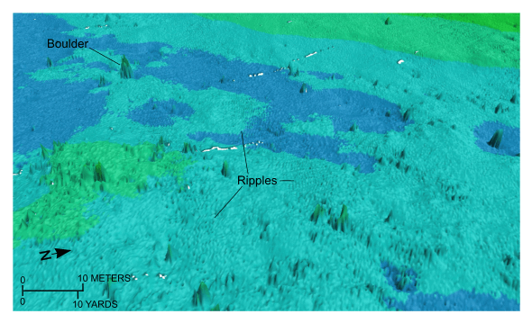
Figure 40. Detailed perspective view of the bathymetry in the southeastern part of the study area from the digital terrain model produced during National Oceanic and Atmospheric Administration survey H11077 of Woods Hole, Massachusetts. Note the abundance of boulders and small patches of rippled sand indicative of the exposed glacial drift and the thin, patchy nature of the Holocene deposits in this part of Vineyard Sound. Location of view is shown in figure 19. | ||


