USGS: science for a changing world - www.usgs.gov
Coastal and Marine Geology Program home - marine.usgs.gov
  U.S. Geological Survey Open-File Report 02-002


Location of MMS 88 cores collected during cruise R/V ATLANTIC TWIN 88-1 (AT88-1) shown in relationship to Long Island Sound area

MMS88: Location of cores collected during cruise R/V ATLANTIC TWIN 88-1 (AT-88-1)


Metadata also available as: FAQ - TEXT

Metadata:


Identification_Information:
Citation:
Citation_Information:
Originator: Mary DiGiacomo-Cohen(comp.)
Publication_Date: 2002
Title:
MMS88: Location of cores collected during cruise R/V ATLANTIC TWIN 88-1 (AT-88-1)
Geospatial_Data_Presentation_Form: vector digital data
Publication_Information:
Publication_Place: Woods Hole Field Center
Publisher: U.S. Geological Survey, Coastal and Marine Geology Program
Online_Linkage: <http://woodshole.er.usgs.gov/openfile/of02-002/data/cores/mms88/>
Larger_Work_Citation:
Citation_Information:
Originator: Larry Poppe
Originator: Valerie Paskevich
Publication_Date: 2002
Title:
Geological Framework data from Long Island Sound, 1981-1990: A Digital Data Release
Geospatial_Data_Presentation_Form: atlas
Series_Information:
Series_Name: U.S. Geological Survey Open-File Report
Issue_Identification: 02-002
Publication_Information:
Publication_Place: Woods Hole, MA
Publisher: U.S. Geological Survey, Coastal and Marine Geology Program
Description:
Abstract:
This GIS layer contains the station navigation for vibracores collected in Long Island Sound during 1988. These cores were originally collected to study nearshore geologic framework.
Purpose:
The purpose is to disseminate a digital version of a regional map showing the distribution of vibracores collected during 1988 in Long Island Sound aboard the Atlantic Twin as part of a cooperative between New England coastal states and the Minerals Management Service. These cores, which were used to verify interpretations of high-resolution seismic-reflection profiles, can be used to provide useful information about the framework geology in this region.
Time_Period_of_Content:
Time_Period_Information:
Single_Date/Time:
Calendar_Date: 19880918
Time_of_Day: 19880921
Currentness_Reference: publication date
Status:
Progress: Complete
Maintenance_and_Update_Frequency: None planned
Spatial_Domain:
Bounding_Coordinates:
West_Bounding_Coordinate: -73.308334
East_Bounding_Coordinate: -71.210000
North_Bounding_Coordinate: 41.380000
South_Bounding_Coordinate: 41.023331
Keywords:
Theme:
Theme_Keyword_Thesaurus: General
Theme_Keyword: U.S. Geological Survey
Theme_Keyword: USGS
Theme_Keyword: Coastal and Marine Geology Team
Theme_Keyword: Coastal and Marine Geology Program
Theme_Keyword: Woods Hole Field Center
Theme_Keyword: ArcView
Theme_Keyword: arcview
Theme_Keyword: shapefile
Theme_Keyword: navigation
Theme_Keyword: vibracores
Theme_Keyword: core locations
Theme_Keyword: cores
Theme_Keyword: MMS
Theme_Keyword: AT-88-1
Theme_Keyword: AT88-1
Theme_Keyword: R/V ATLANTIC TWIN
Theme_Keyword: Minerals Management Service
Place:
Place_Keyword_Thesaurus: General
Place_Keyword: Long Island Sound
Place_Keyword: Connecticut
Place_Keyword: New York
Place_Keyword: Long Island Sound
Access_Constraints: None
Use_Constraints:
The U.S. Geological Survey, Connecticut DEP, and the U.S. Minerals Management Service must be referenced as the originators of the dataset in any future products or research derived from these data. Although this derived data set and its lineage dataset have been used by the USGS, no warranty, expressed or implied, is made by the USGS as to the accuracy of the data and/or related materials. The act of distribution shall not constitute any such warranty, and no responsibility is assumed by the USGS in the use of these data or related materials.
Point_of_Contact:
Contact_Information:
Contact_Organization_Primary:
Contact_Organization: U.S. Geological Survey
Contact_Person: Larry Poppe
Contact_Position: Geologist
Contact_Address:
Address_Type: mailing and physical address
Address: 384 Woods Hole Road
City: Woods Hole
State_or_Province: MA
Postal_Code: 02543-1598
Country: USA
Contact_Voice_Telephone: (508) 548-8700 x2314
Contact_Facsimile_Telephone: (508) 457-2310
Contact_Electronic_Mail_Address: lpoppe@usgs.gov
Hours_of_Service: 0800-1600
Browse_Graphic:
Browse_Graphic_File_Name: ../../../htmldocs/images/browse/mms88.gif
Browse_Graphic_File_Description:
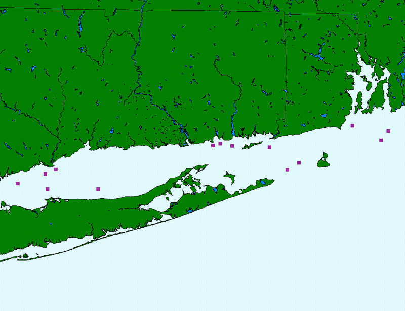
location of MMS88 cores shown in relationship to Long Island Sound area
Browse_Graphic_File_Type: GIF
Data_Set_Credit:
Ralph Lewis the original Connecticut project chief; and Mary DiGiacomo-Cohen and Valerie Paskevich for completing the Arc processing and creation of the GIS data layer.
Native_Data_Set_Environment:
Microsoft Windows 2000 Version 5.0 (Build 2195) Service Pack 2; ESRI ArcCatalog 8.1.1.649
Cross_Reference:
Citation_Information:
Originator: Nancy Neff(comp.)
Originator: Bob McMaster(comp.)
Originator: Ralph Lewis(comp.)
Originator: Hugo Thomas(comp.)
Publication_Date: 1989
Title:
Non-energy resources - Connecticut and Rhode Island coastal waters
Geospatial_Data_Presentation_Form: map
Series_Information:
Series_Name: Final Summary Report to the Minerals Management Service
Issue_Identification: Cooperative Agreement Number 14-12-0001-30387
Publication_Information:
Publication_Place: Hartford, CT
Publisher: Rhode Island and Connecticut DEPs

Data_Quality_Information:
Attribute_Accuracy:
Attribute_Accuracy_Report:
All attribute data were recorded by the chief scientist and entered and checked by the compilers in a consistent manner.
Logical_Consistency_Report:
No additional checks for topological consistency were performed on this data set.
Completeness_Report:
Complete information is provided for all navigation points in the data set.
Positional_Accuracy:
Horizontal_Positional_Accuracy:
Horizontal_Positional_Accuracy_Report:
Navigation was done by Loran C. Typical Loran accuracy for LIS is about 100 m.
Quantitative_Horizontal_Positional_Accuracy_Assessment:
Horizontal_Positional_Accuracy_Value: +/-100 m
Horizontal_Positional_Accuracy_Explanation: Typical positioning accuracy of Loran C
Vertical_Positional_Accuracy:
Vertical_Positional_Accuracy_Report: Tides are less than 2 m
Quantitative_Vertical_Positional_Accuracy_Assessment:
Vertical_Positional_Accuracy_Value: <2m
Vertical_Positional_Accuracy_Explanation: Tides are less than 2 m.
Lineage:
Source_Information:
Source_Citation:
Citation_Information:
Originator: Nanc Neff(comp.)
Originator: Bob McMaster(comp.)
Originator: Ralph Lewis(comp.)
Originator: Hugo Thomas(comp.)
Publication_Date: 19890000
Title:
Non-energy resources - Connecticut and Rhode Island coastal waters
Geospatial_Data_Presentation_Form: map
Series_Information:
Series_Name: Final Summary Report to the Minerals Management Service
Issue_Identification: Cooperative Agreement Number 14-12-0001-30387
Publication_Information:
Publication_Place: Hartford
Publisher: Rhode Island and Connecticut DEPs
Source_Scale_Denominator: 80,000
Type_of_Source_Media: Vibracore cruise logs and report, navigated with LORAN-C
Source_Time_Period_of_Content:
Time_Period_Information:
Single_Date/Time:
Calendar_Date: 19880000
Source_Currentness_Reference: publication date
Source_Citation_Abbreviation: MMS core location navigation logs
Source_Contribution:
Vibra cores were colected as part of a cooperative program between MMS and New England coastal states. This dataset contains the locations of those cores collected in Long Island Sound.
Process_Step:
Process_Description:
Navigation points from the original onboard logs were hand plotted on charts with Loran overlays. These overlays were then registered and digitized (using a Calcomp 9100 table and PC Arc/Info) to create point coverages with CT state plane coordinates. Attributes were added.
Source_Used_Citation_Abbreviation: MMS core location navigation logs
Process_Date: 1991
Source_Produced_Citation_Abbreviation: ATCores navigation coverage
Process_Contact:
Contact_Information:
Contact_Organization_Primary:
Contact_Organization: Connecticut DEP
Contact_Person: Mary DiGiacomo-Cohen
Contact_Address:
Address_Type: mailing and physical address
Address:
Long Island Sound Resource Center UCONN Avery Point 1080 Shennecossett Road
City: Groton
State_or_Province: CT
Postal_Code: 06340
Country: USA
Contact_Voice_Telephone: (860) 405-9015
Contact_Electronic_Mail_Address: lisrc@uconnvm.uconn.edu
Process_Step:
Process_Description:
The navigation coverage was projected to Latitude/Longitude using Arc/Info. Decimal degree coordinates were ungenerated and joined to the attribute table. A shapefile was generated using ArcView.
Source_Used_Citation_Abbreviation: ATCores navigation coverage
Process_Date: 2001
Source_Produced_Citation_Abbreviation: ATCores navigation coverage
Process_Contact:
Contact_Information:
Contact_Organization_Primary:
Contact_Organization: Connecticut DEP
Contact_Person: Mary DiGiacomo-Cohen
Contact_Address:
Address_Type: mailing and physical address
Address:
Long Island Sound Recource Center UCONN Avery Point 1080 Shennecossett Road
City: Groton
State_or_Province: CT
Postal_Code: 06340
Country: USA
Contact_Voice_Telephone: (860)405-9015
Contact_Electronic_Mail_Address: lisrc@uconnvm.uconn.edu
Process_Step:
Process_Description:
The AT88-1 shapefile name was changed to be more descriptive within the USGS Open-File Report 02-002.
Source_Used_Citation_Abbreviation: ATCores navigation coverage
Process_Date: 20020403
Source_Produced_Citation_Abbreviation: mms88.dbf
Source_Produced_Citation_Abbreviation: mms88.shp
Source_Produced_Citation_Abbreviation: mms88.shx
Source_Produced_Citation_Abbreviation: mms88.sbn
Source_Produced_Citation_Abbreviation: mms88.sbx
Process_Contact:
Contact_Information:
Contact_Person_Primary:
Contact_Person: Valerie Paskevich
Contact_Organization: U.S. Geological Survey
Contact_Position: Computer Specialist
Contact_Address:
Address_Type: mailing and physical address
Address: 384 Woods Hole Road
City: Woods Hole
State_or_Province: MA
Postal_Code: 02543=1598
Country: USA
Contact_Voice_Telephone: (508) 548-8700 x2281
Contact_Facsimile_Telephone: (508) 457-2310
Contact_Electronic_Mail_Address: vpaskevich@usgs.gov
Process_Step:
Process_Description:
Added the attribute field URL to include the relative path name from the ArcView project home to the text description of the associated core.
Source_Used_Citation_Abbreviation: mms88.dbf
Process_Date: 20020404
Process_Time: 0820
Source_Produced_Citation_Abbreviation: mms88.dbf
Process_Contact:
Contact_Information:
Contact_Person_Primary:
Contact_Person: Valerie Paskevich
Contact_Organization: U.S. Geological Survey
Contact_Position: Computer Specialist
Contact_Address:
Address_Type: mailing and physical address
Address: 384 Woods Hole Road
City: Woods Hole
State_or_Province: MA
Postal_Code: 02543-1598
Country: USA
Contact_Voice_Telephone: (508) 548-8700 x2281
Contact_Facsimile_Telephone: (508) 457-2310
Contact_Electronic_Mail_Address: vpaskevich@usgs.gov

Spatial_Data_Organization_Information:
Direct_Spatial_Reference_Method: Vector
Point_and_Vector_Object_Information:
SDTS_Terms_Description:
SDTS_Point_and_Vector_Object_Type: Entity point
Point_and_Vector_Object_Count: 14

Spatial_Reference_Information:
Horizontal_Coordinate_System_Definition:
Geographic:
Latitude_Resolution: 0.000000
Longitude_Resolution: 0.000000
Geographic_Coordinate_Units: Decimal degrees
Geodetic_Model:
Horizontal_Datum_Name: North American Datum of 1927
Ellipsoid_Name: Clarke 1866
Semi-major_Axis: 6378206.400000
Denominator_of_Flattening_Ratio: 294.978698

Entity_and_Attribute_Information:
Detailed_Description:
Entity_Type:
Entity_Type_Label: mms88
Entity_Type_Definition: shapefile attribute table
Entity_Type_Definition_Source: ESRI
Attribute:
Attribute_Label: FID
Attribute_Definition: Internal feature number.
Attribute_Definition_Source: ESRI
Attribute_Domain_Values:
Unrepresentable_Domain:
Sequential unique whole numbers that are automatically generated.
Attribute_Domain_Values:
Range_Domain:
Attribute_Units_of_Measure: none
Attribute_Measurement_Resolution: 1
Attribute:
Attribute_Label: Shape
Attribute_Definition: Feature geometry.
Attribute_Definition_Source: ESRI
Attribute_Domain_Values:
Unrepresentable_Domain: Coordinates defining the features.
Attribute_Domain_Values:
Enumerated_Domain:
Enumerated_Domain_Value: Point
Enumerated_Domain_Value_Definition: point data
Enumerated_Domain_Value_Definition_Source: compiler
Attribute:
Attribute_Label: CRUISEID
Attribute_Definition: Name given to cruise during which the cores were collected.
Attribute_Definition_Source: assigned
Attribute_Domain_Values:
Enumerated_Domain:
Enumerated_Domain_Value: AT-88-1
Enumerated_Domain_Value_Definition: identifier assigned to cruise R/V ATLANTIC TWIN 88-1
Enumerated_Domain_Value_Definition_Source: Chief Scientist
Attribute_Domain_Values:
Range_Domain:
Attribute_Units_of_Measure: none
Attribute_Measurement_Resolution: Not applicable
Beginning_Date_of_Attribute_Values: 19880918
Ending_Date_of_Attribute_Values: 19880921
Attribute:
Attribute_Label: DATE
Attribute_Definition: Date when core was collected.
Attribute_Definition_Source: Original logs generated aboard the Atlantic Twin
Attribute_Domain_Values:
Enumerated_Domain:
Enumerated_Domain_Value: 09/18/88
Enumerated_Domain_Value_Definition: Date core was collected recorded as ASCII string.
Enumerated_Domain_Value_Definition_Source: Attribute summary of mms88.dbf compiled by program dbfmeta.
Enumerated_Domain:
Enumerated_Domain_Value: 09/19/88
Enumerated_Domain_Value_Definition: Date core was collected recorded as ASCII string.
Enumerated_Domain_Value_Definition_Source: Attribute summary of mms88.dbf compiled by program dbfmeta.
Enumerated_Domain:
Enumerated_Domain_Value: 09/20/88
Enumerated_Domain_Value_Definition: Date core was collected recorded as ASCII string.
Enumerated_Domain_Value_Definition_Source: Attribute summary of mms88.dbf compiled by program dbfmeta.
Enumerated_Domain:
Enumerated_Domain_Value: 09/21/88
Enumerated_Domain_Value_Definition: Date core was collected recorded as ASCII string.
Enumerated_Domain_Value_Definition_Source: Attribute summary of mms88.dbf compiled by program dbfmeta.
Enumerated_Domain:
Enumerated_Domain_Value: 09/88
Enumerated_Domain_Value_Definition:
Date core was collected recorded as ASCII string. Day of month unknown.
Enumerated_Domain_Value_Definition_Source: Attribute summary of mms88.dbf compiled by program dbfmeta.
Beginning_Date_of_Attribute_Values: 19880918
Ending_Date_of_Attribute_Values: 19880921
Attribute_Value_Accuracy_Information:
Attribute_Value_Accuracy: months, days, and years
Attribute_Value_Accuracy_Explanation: Values are for months, days, and years
Attribute:
Attribute_Label: COREID
Attribute_Definition:
Numbers assigned to cores collected during cruise R/V Atlantic Twin 88-1 (AT88-1)
Attribute_Definition_Source: Ralph Lewis, CT DEP
Attribute_Domain_Values:
Enumerated_Domain:
Enumerated_Domain_Value: AT88-1 thru AT88-14
Enumerated_Domain_Value_Definition:
ASCII character string (AT88) followed by assigned sequential numeric integer of core
Enumerated_Domain_Value_Definition_Source: Chief Scientist
Beginning_Date_of_Attribute_Values: 19880918
Ending_Date_of_Attribute_Values: 19880921
Attribute:
Attribute_Label: LAT
Attribute_Definition: Latitude in decimal degrees of the navigation point
Attribute_Definition_Source: Compiler
Attribute_Domain_Values:
Range_Domain:
Range_Domain_Minimum: 41.023331
Range_Domain_Maximum: 41.280003
Attribute_Units_of_Measure: decimal degrees
Attribute_Measurement_Resolution: 0.000001
Beginning_Date_of_Attribute_Values: 19880918
Ending_Date_of_Attribute_Values: 19880921
Attribute_Value_Accuracy_Information:
Attribute_Value_Accuracy: 0.000001
Attribute_Value_Accuracy_Explanation:
See process steps - lat/lon decimal degrees result from hand plotted loran coords which have been projected.
Attribute:
Attribute_Label: LON
Attribute_Definition: Longitude in decimal degrees of the navigation point
Attribute_Definition_Source: Compiler
Attribute_Domain_Values:
Range_Domain:
Range_Domain_Minimum: -72.093338
Range_Domain_Maximum: -73.308334
Attribute_Units_of_Measure: Decimal degrees
Attribute_Measurement_Resolution: 0.000001
Beginning_Date_of_Attribute_Values: 19880918
Ending_Date_of_Attribute_Values: 19880921
Attribute_Value_Accuracy_Information:
Attribute_Value_Accuracy: 0.000001
Attribute_Value_Accuracy_Explanation:
See process steps - lat/lon decimal degrees result from hand plotted loran coords which have been projected.
Attribute:
Attribute_Label: URL
Attribute_Definition:
Link to the HTML page containing the text description of the associated core. URL path is relative to the ArcView project home.
Attribute_Definition_Source: Processor
Attribute_Domain_Values:
Unrepresentable_Domain:
Relative path and filename containing the text description of the associated core.
Overview_Description:
Entity_and_Attribute_Overview:
This datalayer (navigation of the 1988 MMS cores from LIS) provides information location of vibracores used to interpret the regional geologic framework.
Entity_and_Attribute_Detail_Citation:
Geological Framework data from Long Island Sound, 1981-1990: a digital release

Distribution_Information:
Distributor:
Contact_Information:
Contact_Organization_Primary:
Contact_Organization: U.S. Geological Survey
Contact_Person: Larry Poppe
Contact_Position: Geologist
Contact_Address:
Address_Type: mailing and physical address
Address: 384 Woods Hole Road
City: Woods Hole
State_or_Province: MA
Postal_Code: 02543-1598
Country: USA
Contact_Voice_Telephone: (508) 548-8700 x2314
Contact_Facsimile_Telephone: (508) 457-2310
Contact_Electronic_Mail_Address: lpoppe@usgs.gov
Resource_Description: Long Island Sound: mms88.shp
Distribution_Liability:
Although this derived data set and its lineage dataset have been used by the USGS, no warranty, expressed or implied, is made by the USGS as to the accuracy of the data and/or related materials. The act of distribution shall not constitute any such warranty, and no responsibility is assumed by the USGS in the use of these data or related materials.
Standard_Order_Process:
Digital_Form:
Digital_Transfer_Information:
Format_Name: ArcView shapefile
Format_Version_Number: 3.2
Format_Information_Content:
The seven ArcView shapefiles (mms88.dbf, mms88.shp, mms88.shx, mms88.avl, mms88.sbn, mms88.sbx, mms88.prj) comprising the navigation point data for the AT88-1 vibracore cruise in Long Island Sound and an ASCII version of the metadata.
File_Decompression_Technique: zip
Transfer_Size: 7.46Kbytes
Digital_Transfer_Option:
Online_Option:
Computer_Contact_Information:
Network_Address:
Network_Resource_Name:
<http://woodshole.er.usgs.gov/openfile/of02-002/data/cores/mms88/mms88.zip>
Offline_Option:
Offline_Media: DVD
Recording_Capacity:
Recording_Density: 4.7
Recording_Density_Units: Gbytes
Recording_Format: UDF
Compatibility_Information:
The user must have a system with a DVD drive capable of reading an UDF standard DVD-R disk. To browse the information contained on this disk, the user must also have a current version of WWW browser available. The user must also have the software installed on their computer system capable to unzip the archived file.
Custom_Order_Process: None
Technical_Prerequisites:
The AT88-1 navigation overlay is available in an ArcView shapefile format. The user must have ESRI's ArcView 3.0 or greater software to read and process the data file. In lieu of Arcview, the user may utilize another GIS application package capable of importing the data.
Available_Time_Period:
Time_Period_Information:
Single_Date/Time:
Calendar_Date: 2002

Metadata_Reference_Information:
Metadata_Date: 20020404
Metadata_Contact:
Contact_Information:
Contact_Person_Primary:
Contact_Person: Valerie Paskevich
Contact_Organization: U.S. Geological Survey
Contact_Position: computer specialist
Contact_Address:
Address_Type: mailing and physical address
Address: 384 Woods Hole Road
City: Woods Hole
State_or_Province: MA
Postal_Code: 02543-1598
Country: USA
Contact_Voice_Telephone: (508) 548-8700 x2281
Contact_Facsimile_Telephone: (508) 457-2310
Contact_Electronic_Mail_Address: vpaskevich@usgs.gov
Metadata_Standard_Name: FGDC Content Standards for Digital Geospatial Metadata
Metadata_Standard_Version: FGDC-STD-001-1998
Metadata_Time_Convention: local time
Metadata_Access_Constraints: None
Metadata_Use_Constraints: None

Generated by mp version 2.7.3 on Thu Apr 04 08:44:37 2002