USGS: science for a changing world - www.usgs.gov
Coastal and Marine Geology Program home - marine.usgs.gov

U.S. Geological Survey Open-File Report 02-002

Geological Framework Data from Long Island Sound, 1981-1990:

A Digital Data Release

Block Island Sound: AST82-3 Navigation Discussion
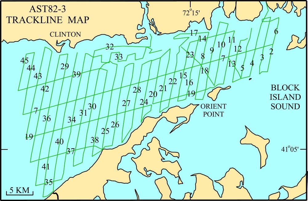
 

Skip Table of Contents group; go to navigation discussionOFR02-002 Home: return to OFR02-002 homepageINTRODUCTION: go to introductionSEISMIC DATA: Go to seismic data discussion
 Block Island Sound
 Eastern Long Island Sound Summary Report
 Cruise Report
 Seismic Profiles
  Trackline Navigation
 East-Central Long Island Sound
 West-Central Long Island Sound
 Western Long Island Sound
 Fishers Island Sound and Northeastern Long Island Sound  CORE DATA: Go to core data discussionPHOTO GALLERY: view photos of cruise activities and equipmentDATA CATALOG: Go to data catalog and browse available dataREFERENCES: view suggested referencesRELATED WEBSITES: go to a list of Long Island Sound related websitesACKNOWLEDGMENTS: view acknowledgmentsCONTACTS: view contact informationDISCLAIMER: view disclaimer informationREADME: view readme information

AST82-3 NAVIGATION

The maps below show the tracklines along which the seismic data were collected on leg 3 of the 1982 RV ASTERIAS cruise. The upper image shows the locations of lines 2-45 in eastern Long Island Sound. The lower image shows the location of line 1, a minisparker line run in Block Island Sound.

Map illustration: R/V ASTERIAS cruise 82-3 tracklines in Eastern Long Island Sound.  Larger map will open in new browser window.

Map illustration: R/V ASTERIAS cruise 82-3 tracklines in Eastern Long Island Sound.  Larger map will open in new browser window.

Map illustration: R/V ASTERIAS cruise 82-3 tracklines in Eastern Long Island Sound and a single
minisparker line in Block Island Sound. Click on the above image to open a larger map in a new
browser window.  Links to the navigation data are available in the table below.


The navigation files, which are located in the data/nav/82_3nav directory at the top level of this report, are provided in two formats:


ASCII comma-delimited text a82_3nav.txt

ArcView Shapefile

   
zip archive file
zip archive file

These files are a compilation of all the navigation collected on the cruise and have the following data fields: cruise id, date, time (EDST), seismic line, and latitude and longitude in decimal degrees. To download the navigation data from the DVD the user has a couple of options. One option is available while viewing any of the data files through the links above. The user may select the Save As option from the pulldown menu from the File option located on the menu bar. When prompted, the user may then enter the directory and filename of where the data file will be stored on disk. A second option is to access the DVD outside of a WWW browser and copy the file from the data/nav directory on the DVD to a desired location.

Connecticut Department of Environmental Protection


Department of the Interior > U.S. Geological Survey > Coastal and Marine Geology Program > Long Island Sound Studies
Contact: L.J. Poppe (lpoppe@usgs.gov")