|
U.S. Geological Survey Open-File Report 02-002
Geological Framework Data from Long Island Sound, 1981-1990:
A Digital Data Release
Eastern Long Island Sound: Summary Report
|
|
USGS MISCELLANEOUS FIELD STUDIES MAP MF-1939-AThe report presented below (Lewis and Needell, 1987) was previously published as a Miscellaneous Field Studies Map by the U.S. Geological Survey and is included here solely to broaden the perspective and understanding of those individuals interested in the geologic framework and the Late Quaternary depositional history of eastern Long Island Sound. The results presented in Lewis and Needell (1987) are preliminary. Final interpretations and a regional perspective are presented in Lewis and Stone (1991) and Lewis and DiGiacomo-Cohen (2000).
MAPS SHOWING THE STRATIGRAPHIC FRAMEWORK AND QUATERNARY GEOLOGIC HISTORY OF EASTERN LONG ISLAND SOUNDRalph S. Lewis and Sally W. NeedellU.S. Geological Survey Miscellaneous Field Studies Map MF-1939-A1987ABSTRACTThe stratigraphic framework and Quaternary geologic history of eastern Long Island Sound have been interpreted from high-resolution, seismic-reflection profiles supplemented by information from vibracores and from previous geologic studies conducted in the Sound and surrounding areas. Seven sedimentary units are inferred from the subbottom profiling: 1) coastal-plain strata of Late Cretaceous age, 2) glacial drift (possibly stratified) of Pleistocene age, 3) end-moraine deposits of Pleistocene age, 4) glacial deposits (mostly till) of Pleistocene age, 5) glaciolacustrine deposits of late Pleistocene age, 6) fluvial and estuarine deposits of Holocene age (possibly very late Pleistocene to the east), and 7) marine deposits of Holocene age. The preglacial landscape of the area consisted of a fluvially carved lowland that was floored by crystalline rocks of pre-Mesozoic age and was bounded to the south by an irregular, north-facing cuesta in coastal-plain strata. Pleistocene glacial erosion rounded and modified this landscape but its fluvial aspect was basically preserved. Three or four south-flowing Tertiary to early Pleistocene (-) fluvial systems drained the inner lowland (at times of lower sea level) and coalesced to join drainage from the Block Island Sound lowland east of Gardiners Island. Glacial drift, including moraines, till, and probably some stratified material, was deposited over the modified preglacial surface during the Pleistocene ice advances. As the last ice (Late Wisconsinan) retreated, meltwater was dammed north of the moraines and extensive lake sediments were laid down. Prior to the Holocene marine transgression, the morainal dams failed, the meltwater lake drained, and the drift was eroded by streams that flowed across a subaerially exposed lakebed. Ponds may have occupied closed depressions in the lake bottom. An outlet for the drainage system that developed on the exposed lakebed is likely to have existed along the eastern end of the Roanoke Point-Orient Point-Fishers Island moraine (Sirkin, 1982), possibly east of Great Gull Island. With the onset of the Holocene submergence, the drift was covered by a variety of sediments, which included fluvial deposits, freshwater peat, salt-marsh deposits, and estuarine deposits. Subsequent wave action associated with the transgressing sea cut away most of this cover and beveled the top of the glaciolacustrine sediments. Deposition of a thick and locally complex accumulation of marine sediment followed the wave cutting. Strong tidal currents developed in the constricted easternmost portion of Long Island Sound as the sea deepened. These currents began to rework and eventually remove sediment from the area east of Six Mile Reef, a process that is continuing. Recently obtained vibracores in Long Island Sound, which penetrated Holocene marine and fluvial sediment and upper Wisconsinan lacustrine sediments, substantiate inferences drawn from the seismic-reflection profiles. INTRODUCTION
Previous studies of the subbottom in Long Island Sound have outlined the general relationship of bedrock, coastal-plain, and glacial-drift surfaces. Oliver and Drake (1951) presented the first depth-to-bedrock map of Long Island and Block Island Sounds (Figure 1). Later, Tagg and Uchupi (1967) further described the bedrock surface as low-relief topography overlain by unconsolidated sediments. Zurflueh (1962) presented a map of total magnetic intensity for the Long Island Sound. Several of the bedrock valleys in and around eastern Long Island Sound were discussed by Upson and Spencer (1964), and McMaster and Ashraf (1973). Hollick (1893), Newman and Fairbridge (1960), Frankel and Thomas (1966), and Bertoni and others (1977), among others, have presented evidence of freshwater-lake deposits in Long Island Sound and vicinity. Glacial deposits associated with the study area have been examined by several investigators (Goldsmith, 1960; Schafer, 1961; Flint and Gebert, 1976; Sirkin, 1976). Akpati (1974) assessed the mineral composition and distribution of bottom sediments in eastern Long Island Sound. The inferred geology of Long Island Sound has been summarized by Grim and others (1970), Gordon (1980), and Williams (1981). These workers describe the coastal-plain remnant as a highly dissected cuesta, cut in strata of Cretaceous age, that lies on an irregular, south-dipping bedrock (Paleozoic-) surface. Gordon (1980) presented a generalized map showing the inferred position of the cuesta in Long Island and Block Island Sounds. ACKNOWLEDGMENTSThe authors wish to thank Arthur D. Colburn, Captain of the
R/V ASTERIAS of the Woods Hole GEOLOGIC SETTINGMost of the bedrock that lies under eastern Long Island Sound is believed to consist of metamorphic and igneous rocks of pre-Mesozoic age. The portions of southeastern Connecticut that abut the Sound are primarily underlain by Precambrian(-) and Paleozoic gneisses and granites of the Avalonian Terrane (Rodgers, 1985). Seaward, drill holes have encountered granite under Fishers Island (Fuller, 1905), and granite gneiss and schist under central and eastern Long Island (Suter and others, 1949; de Laguna, 1963; Pierce and Taylor, 1975). The morphology and structure of the submerged bedrock is poorly defined, but the aeromagnetic map of Harwood and Zietz (1977) indicates that the complex bedrock structure of southeastern Connecticut extends offshore. A generalized, south-dipping bedrock surface under eastern Long Island Sound is presented on the structure-contour maps of Grim and others (1970) and McMaster and Ashraf (1973). Both of these maps show south-southeast- Coastal-plain sediments of Cretaceous age consisting of unconsolidated to semi-consolidated gravels, sands, silts, and clays have been reported on Block Island (Tuttle and others, 1961; Sirkin, 1976) and along the north shore of Long Island (Fuller, 1914; de Laguna, 1963; Suter and others, 1949). McMaster and others (1968) identified a seaward-dipping, erosional remnant of the coastal-plain strata overlying bedrock unconformably in the southern portion of Block Island Sound (Figure 1); the cuesta formed by this remnant can be traced westward to the vicinity of Plum Island (Needell and Lewis, 1984). Grim and others (1970) demonstrated the agreement of contours drawn to the inferred Cretaceous surface both on land and offshore in the Smithtown Bay area of western Long Island, and provided data showing a highly dissected Cretaceous remnant trending roughly northeastward from Glen Cove (Figure 1) to Horton Point on the north fork of Long Island. Their discussion revisits earlier speculation (Veatch, 1906; Fuller, 1914) that the Long Island Sound lowland was formed principally by fluvial erosion and later glacially modified. In southern Connecticut and along the north shore of Long Island, the bedrock and coastal-plain strata are unconformably overlain by two drift sheets. The older of these sheets is commonly attributed to pre-late-Wisconsinan events, whereas the younger sheet is a product of the late Wisconsinan ice advance (Donner, 1964; Sirkin 1971, 1976, 1982; Mills and Wells, 1974). Two series of end moraines cross the southern New England inner continental shelf (Schafer and Hartshorn, 1965; Sirkin, 1982). The outermost moraines, which mark the maximum seaward extent of the last Pleistocene glaciation, lie across central and southeastern Long Island (Fuller, 1914; Sirkin, 1982). To the north, a second line of moraines caps northern Long Island, Plum Island, and Fishers Island and extends eastward across southern Rhode Island (Crandell, 1962; Schafer and Hartshorn, 1965). Sirkin (1982) argued that recessional moraines lie between the two classically recognized Harbor Hill (northern) and Ronkonkoma (southern) moraines, and that these recessional moraines extend into Gardiners Bay and Block Island Sound. Several moraine segments and the remnants of outwash heads and deltas have been recognized along the coast of Connecticut, and some of these features can be traced into northern Long Island Sound (Goldsmith, 1982; Flint and Gebert, 1976). Coch and others (1974) cored the bottom and sides of Little Gull Channel (just east of Great Gull Island, Figure 2) south of a submerged segment of the Harbor Hill moraine. Their findings suggest that late Pleistocene streams carried Harbor Hill moraine material southward through the stream-cut channel and deposited this reworked morainal material over an extensive deposit of laminated, light-red clay that contains concretions. Akpati (1974) reported that the bottom sediments of eastern Long Island Sound are predominantly made up of muddy sands that are slightly gravelly in spots. Locally, currents have stripped away this bottom material and exposed older strata. Methods
The base map for this work was constructed from U.S. Coast and Geodetic Survey Bathymetric Map 0808N-53 that was published at a scale of 1:125,000 (U.S. Department of Commerce, 1967). The geologic significance of the major acoustic reflectors recognized in these data was inferred by correlating them to the stratigraphic control available in and adjacent to the survey area. The depth below present sea level to the acoustic reflectors was determined using assumed compressional-wave velocities of 1,500 m/s for water and sediments inferred to be of Holocene age, 1,800 m/s for sediments inferred to be of Pleistocene age, and 2,500 m/s for sediments inferred to be coastal-plain strata of Cretaceous age. Four cores were obtained using the Alpine Ocean Seismic Survey, Inc. Vibracorer, which is capable of collecting a core 9 cm in diameter and up to 9 m in length from water depths up to 60 m. The Vibracorer uses a pneumatic impacting piston vibrator on top of core pipe fitted with a core liner to penetrate the sediments. Core hole locations are shown on Figure 2. Sea-floor TopographyEastern Long Island Sound has an irregular bottom that is dominated by elongate, roughly east-trending, scours and closed depressions (Figure 2). The majority of these erosional features occur along a line from the western tip of Fishers Island (see Figure 1) to Six Mile Reef (Figure 2). The deepest depression in the eastern Sound lies northeast of Great Gull Island and is about 100 m below mean sea level. East and west of Great Gull Island, between Fishers Island and Orient Point, a string of emerged and submerged ridges form the boundary between Long Island Sound and Block Island Sound (Figure 1). Several steep-sided, deep, closed depressions border this area to the north. Westward, along the north fork of Long Island, the drop to the depressions becomes more gradual, and the deepest part of the sound is near its middle. The northern half of eastern Long Island Sound, which lies between Fishers Island and Hatchet Reef, slopes gently southward to the line of scours. Water depths in the 7- to 18-m range are common there. West of Hatchet Reef, the area north of the scour line is dominated by an east-trending shoal (Long Sand Shoal, Figure 2) and by a line of elongate ridges that extend westward from Cornfield Point. Stratigraphy and Interpretation of Seismic Units
In the southern half of the study area, energy from our seismic source did not penetrate to crystalline bedrock through thicker sections of an overlying stratigraphic unit. This overlying unit is characterized by a strong, generally continuous surface reflector and by the local presence of well-defined, gently south-dipping internal reflectors that probably represent bedding; we infer that this unit (e.g. Figure 3C, unit Ku) is composed of coastal-plain sediments of Cretaceous age. Near the margins of the coastal-plain remnant, the coastal-plain strata are often truncated at an erosional scarp and where these strata are thin, the bedrock surface (e.g. Figure 3F, unconformity uf3) can be traced for a short distance beneath the coastal-plain deposit. Similar relationships between coastal-plain deposits and crystalline bedrock have been observed throughout the inner shelf of southern New England (Grim and others, 1970; McMaster and others, 1968; Needell and Lewis, 1984). Since we were not able to map the bedrock surface where it lies protected under thicker coastal-plain deposits (e.g. Figure 3C, unconformity uf3) we chose to map the oldest erosional surface that could be traced throughout the eastern Sound (except in areas designated "GAS NO DATA," Figures 6, 7, 8, 9, 10, 11 and 12, where the gas content of surficial sediments precluded subbottom mapping). This surface (e.g. Figure 3B, unconformity uf2) forms the top of the coastal-plain deposit and, where coastal-plain strata are absent, it continues as the top of the crystalline bedrock. Glacial drift (e.g. Figure 3F) as thick as 150 m unconformably overlies bedrock and coastal-plain strata. The drift varies in acoustic character and, based on its stratigraphic position and relationship to onshore geomorphic features, is thought to represent outwash, till, ice-contact stratified drift, drift deformed by overriding ice, and glaciolacustrine sediment. Outwash is characterized by flat-lying and gently dipping reflectors. Drift that exhibits highly irregular and discontinuous internal reflectors is thought to be till, ice-contact drift, and (or) ice-deformed drift. Deposits of outwash and ice-contact stratified drift (unit Qd, Figure 3D, 3E, and 3F) are usually preserved as local deposits on both bedrock and coastal-plain valley floors and walls. In most cases, these deposits are overlain by glaciolacustrine or moraine and till deposits. End-moraine (unit Qtm, Figure 3C and
3D) and till (unit Qt,
Figure 3A, 3D,
3E, and 3F) deposits consist of till, stratified drift, and older incorporated material. These deposits are positive relief features and are identified in the subbottom records by a well-defined surface reflector that obscures underlying reflectors. The unit designation "end moraine deposit" (Qtm) is used to differentiate features that are obvious offshore extensions of known onshore
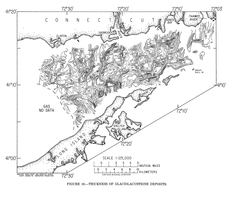
Drift that is characterized by laminated acoustic reflectors that mimic the underlying unconformity is inferred to be sediment deposited in proglacial lakes. The glaciolacustrine deposits (unit Qgl, e.g. Figure 3F) are the most extensive and the youngest of the deposits within the glacial drift. Core data (Figure 4) and previous studies (Frankel and Thomas, 1966; Bertoni and others, 1977) indicate that the glacial lake deposits are composed primarily of laminated (probably varved) silt and clay, with local lenses of coarser sediment. Since the laminations appear to mimic the shape of the underlying surface, we infer that they are the result of extensive, quiet-water deposition on the bottom of the lake. A complex surface that was initially cut by post-glacial streams (Figure 3C, unconformity ufl) and later greatly modified by wave and current action (Figure 3F, unconformity um) forms the top of the glaciolacustrine and other glacial deposits. Prominent and continuous acoustic reflectors mark this smooth to very irregular surface (Figure 3F). Where the fluvial unconformity (ufl) is preserved, it can be distinguished from the marine unconformity (um) because it is overlain by thin sediments of inferred fluvial and estuarine origin (unit Qfe, Figure 3C, 3E, and 3F). The fluvial and estuarine deposits are recognized by their internal cut-and-fill structures. Similar deposits, inferred to be composed of fluvial gravel and sand; estuarine sand, silt, and clay; and fresh- and salt-water peat, have been recognized in Block Island Sound (Needell and Lewis, 1984). The marine unconformity (um, e.g. Figure 3F) is represented by a strong, continuous reflector. It cuts the fluvial unconformity (ufl) and truncates the fluvial and estuarine deposits as well as the drift. It is overlain by complex Holocene marine sediments (unit Qm, e.g. Figure 3F), which make up the bulk of the post-glacial deposits. The marine sediments exhibit continuous, flat-lying, and gently dipping internal reflectors, cut-and-fill structures, constructional features, and in some areas a mottled appearance that results from a lack of distinct internal structure. Postglacial marine deposits recovered in all four cores (Figure 4) consist of silty clay, silty sand, sand, gravel, large pebbles, shell fragments and in core number one, peat. Figure 5 presents a synopsis of unit descriptions together with a surficial geologic map and interpretive geologic cross sections that show where the various units are thought to crop out at or very near the sea floor. Depth to Crystalline Bedrock and Submerged Coastal-Plain StrataThe morphology of the glacially modified fluvial surface (uf2) that forms the top of the crystalline bedrock and the
In general, the bedrock surface dips southward from the Connecticut coast, but it is incised by ten prominent valleys, having 50 to 100 m of relief, that trend generally southward. The bedrock interfluves between these valleys extend as identifiable features south-southwestward to the mid-portion of the Sound. Many outliers of coastal-plain strata are inferred to overlie bedrock north of the main coastal-plain (cuesta) remnant. Several of these outliers appear to have been preserved on the south side of the bedrock interfluves. At the toe of the north-facing cuesta slope, the bedrock and coastal-plain contact (heavy, generally northeast-trending dashed line in
Figure 6) is very irregular. Its depth varies from a minimum of about 60 m below sea level in the east to a maximum of about 170 m in the west. Northwest of Shelter Island, N.Y., a large valley
Thickness and Distribution of Glacial DriftThe thickness (up to 150 m) and distribution of the aggregated glacial drift deposits is shown on Figure 8. Aside from limited interfluve areas along the Connecticut coast and a curved strip southeast of Niantic Bay, where modern erosion has probably exposed bedrock and coastal-plain strata (Figures 5 and 8), glacial drift is present throughout the eastern Sound. A separate mapping of the localized outwash and ice-contact stratified drift deposits was not possible, but they are inferred to crop out at the sea floor in several places (unit Qd, Figure 5).
End-moraine, till and glaciolacustrine deposits are inferred to be exposed at the seafloor (units Qtm, Qt, and Qgl, Figure 5) along both coasts and in the easternmost Sound. Depth to Lacustrine and Other Glacial DepositsThe shape of the glacial drift surface (Figure
11) supports the concept that a considerable amount of material has been removed from the easternmost end of Long Island Sound. As mentioned above, glacial drift is locally absent and bedrock and coastal-plain strata are probably exposed at the seafloor southeast of Niantic Bay. Surrounding these exposures, outcroppings of glaciolacustrine, and to a lesser extent, the other glacial deposits look scoured on the seismic records
(Figures 3D and
3F). In more protected areas, the drift is better preserved, and truncated reflectors within the drift remnants provide evidence that relatively thick glacial deposits originally extended
To the west, older wave-cut (urn) and fluvially cut (ufl) components of the drift surface are better preserved (Figure 3F). In the southern portion of the study area between Niantic Bay and the Connecticut River, the morphology of the top of the glaciolacustrine sediment reflects major aspects of the underlying bedrock, coastal-plain and drift surfaces. Along the coast of Long Island, the overall shape of the underlying moraine-capped cuesta remnant is mimicked by the surface of the glaciolacustrine deposits. Just north of this, three closed depressions (60 m contours) in the glaciolacustrine sediment occupy an east-trending low area that corresponds to the deepest portion of the underlying bedrock and coastal-plain surface. From these depressions northward, the gross morphology of the south-dipping surface of the glaciolacustrine deposits differs from that of the underlying bedrock. Several channels that are not related to the position of the underlying bedrock valleys incise the glaciolacustrine deposits (Figure 11). The presence of these channels suggest that streams flowed across the surface of the glaciolacustrine deposits prior to the Holocene submergence. These streams may have fed to shallow ponds that occupied depressions in the original lake bottom. Southwest of the Connecticut River, the glaciolacustrine deposits are also incised by five fairly long channels that appear to drain into a 60- to 65-meter-deep depression. The entire system of streams and ponds may have drained eastward (across the 60 m contours), with an outlet between Great Gull Island and Fishers Island; or, if other low spots in the moraine existed, (e.g. northwest of Shelter Island) more than one outlet may have developed. Thickness and Distribution of Postglacial Deposits
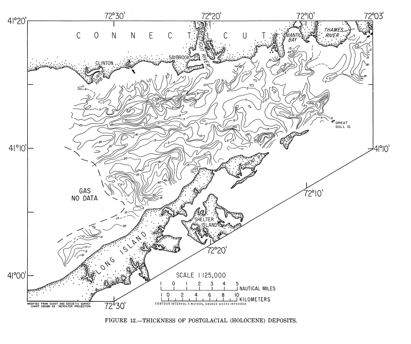
Post-transgressive marine sediments are thickest and most extensive south and west of the Connecticut River. East of there, relatively thick, localized, stratified deposits occur near Niantic Bay, the Thames River, and Plum Island (Figure 12), but post-transgressive marine sediments are generally thin or absent in other areas. The likely source for most of the marine sediment in the western part of the study area, including many of the well-stratified, cut-and-fill, deltaic, and structureless units, was the Connecticut River Valley. Modern currents have carved into many of the older marine deposits (Figure 3B), the remains of which often reveal internal evidence of past erosion and reworking, such as buried constructional features (Figure 3E). Where recent scouring of older material has not occurred but currents are active, modern and reworked sediments blanket the basin. Sand waves having as much as 12 m of relief occur in the mid-Sound south of Saybrook Point (Figure 3F). Shoals and beach-and-bar deposits are common along both coasts. In quiet water environments, a veneer of relatively homogeneous Holocene sediments mantles older deposits. Late Cenozoic Geologic HistoryDuring the Tertiary and early Pleistocene, lower relative sea level (Vail and others, 1977) permitted streams to erode coastal-plain strata, re-exposing bedrock along the thin landward margin of the coastal-plain sedimentary wedge. This erosion eventually formed an inner lowland that was floored by bedrock on its landward flank and bounded seaward by a highly dissected, north-facing escarpment of coastal-plain strata (Figure 6). This lowland adjoined a similar interior lowland in Block Island Sound (Needell and Lewis, 1984). The drainage pattern that developed in the Tertiary and early Pleistocene was modified by glacial erosion during subsequent ice advances and in some places by marine erosion in the Holocene. These modifications partially obscured the preglacial drainage pattern, but it appears that at least three, and possibly four, south-flowing drainage systems shaped the inner lowland between the Thames River and Clinton Harbor (Figure 7). These drainages were separated by north-trending divides. Drainage from the Thames River valley and from the western half of the basin north of Fishers Island (Figure 1) probably flowed south-southwestward across the bedrock surface to a point between Great Gull Island and Fishers Island (Figure 7). There this flow became tributary to a large south-southeastward flowing drainageway that was cut in coastal-plain strata in Block Island Sound (Needell and Lewis, 1984). West of Great Gull Island, drainage from the south-southwestward trending bedrock valleys that lie between the Thames and Connecticut Rivers probably had a southward outlet between Plum Island and Orient Point. The morphology of the preglacial surface in this area (Figure 6) suggests that south-southwestward drainage continued seaward, on bedrock, to about two-thirds of the way across the lowland. At that point the shape of the coastal-plain cuesta began to influence stream courses and drainage merged southeastward and southwestward along the contact of bedrock and coastal-plain strata. The 140-meter-deep (Figure 6) valley (Plum Gut) cut in the coastal-plain strata between Orient Point and Plum Island is a likely outlet for this drainage, which probably then flowed southeastward (Williams, 1981) to join the Block Island Sound drainageway. Drainage from the Connecticut River Valley probably did not flow to the Plum Gut outlet owing to the presence of the Connecticut River-Orient Point divide. Water from the Connecticut River Valley and from bedrock valleys as far west as Clinton Harbor more likely flowed to a large basin west of the divide (Figure 6). Outlets for this flow may have existed north and northwest of Shelter Island (Figure 7), where deep valleys (over 200 m) cut the cuesta (Figure 6). Water leaving the western lowland may have fed to the Block Island Sound drainageway via the large coastal-plain valleys that lie under Gardiners Bay (Williams, 1981). Unlike southern portions of the Block Island Sound inner lowland, evidence of major north-flowing coast-plain tributary valleys and a main east- or west-flowing trunk stream is lacking in eastern Long Island Sound. If western equivalents of the tributary and trunk valleys that dominate southern Block Island Sound exist, they probably lie under Gardiners Bay. During the Pleistocene, glacial ice probably advanced into the Long Island Sound area several times. The last (late Wisconsinan) of these glaciers advanced southward across the inner lowland and ran up the coastal-plain escarpment, overtopping the cuesta. The advancing ice scoured existing valley floors and walls and modified the coastal-plain escarpment, but it did not completely alter the pre-existing fluvial topography. The terminal position of the late Wisconsinan ice lobes is marked by the Ronkonkoma, Shinnecock, and Amagansett moraines (Sirkin, 1982). After reaching this maximum, retreating ice formed several sub-parallel moraines to the north. The most prominent of these runs along the north shore of Long Island, and across Plum Island, the entrance to Long Island Sound (Figure 9), Fishers Island, and the coast of Rhode Island from Watch Hill to Point Judith (Schafer and Hartshorn, 1965; Sirkin, 1982). Further ice retreat formed an east-trending basin between the retreating ice and the moraine-capped cuesta remnant. Meltwater began to fill this basin and as the retreat continued, bands of material that are probably related to the Clumps and Old Saybrook moraines were deposited (Figure 9). These deposits remained submerged as the meltwater lake expanded northward. Eventually, thick glaciolacustrine silt and clay deposits (Figure 10) covered most of the inner lowland, and outwash was deposited locally along the northern lake margin. The morphology of the lake-clay surface (Figure11) indicates that in the eastern end of the Long Island Sound inner lowland, the meltwater lake had almost entirely drained before the rising sea made its final transgression. Assuming an outlet (or outlets) through the Roanoke Point-Orient Point-Fishers Island moraine (Sirkin, 1982), the lake in eastern Long Island Sound could not have emptied until the lake in Block Island Sound (Needell and Lewis, 1984) had drained. Unfortunately, the outlet question is problematic because modern currents have significantly altered the moraine east of Great Gull Island, and the depth to the top of the moraine is not known at other prospective low spots on the moraine (e.g. northwest of Shelter Island). We think that an outlet is most likely to have existed east of Great Gull Island. After the lake level fell, a system of streams and shallow ponds developed on the subaerially exposed lake bottom. The streams carried terrigenous material seaward (south) and peat was deposited in the ponds which occupied depressions in the former lakebed. This system probably spilled from pond to pond (across the 60 m contours) and ultimately fed to the same outlet(s) that drained the lake. As sea level rose, the fluvial sediments and freshwater peats were covered by estuarine deposits and saltmarsh peats (Figure 12). Waves and bottom currents of the transgressing sea reworked older sediment and smoothed the sea floor. Deposition of a thick, extensive, and locally complex accumulation of marine sediment (Figure 12) followed the transgression. The bulk of this deposit probably consists of material derived from the glacial sediments of the Connecticut River Valley. Delivery of this material to Long Island Sound has diminished with time because the present rate of deposition in the Sound is low (Gordon, 1980). From the constricted eastern entrance to Long Island Sound, in the vicinity of Fishers Island, westward to Six Mile Reef, modern tidal currents have locally cut through Holocene deposits and removed much of the underlying glaciolacustrine material as well. Some areas have been eroded deeply enough to expose till, coastal-plain deposits, and bedrock (Figure 5). East of Plum Island, Pleistocene and older material is exposed over much of the sea bottom, and the upper part of the drift and the Holocene section, including evidence of late- and post-glacial events, has been removed. The pattern of this modern erosion and reworking is reflected in the sea-floor topography of the eastern Sound (Figure 2). Outside of the areas where strong currents are active, modern marine sediments are slowly accumulating. REFERENCESAkapati, B.N., 1974, Mineral composition and sediments in eastern Long Island Sound, New York: Maritime Sediments, v. 10, p. 19-30. Bertoni, Remo, Dowling, J.J., and Frankel, Larry, 1977, Freshwater-lake sediments beneath Block Island Sound; Geology, v. 5, p. 631-635. Coch, C.A., Cinquemani, L.J., and Coch, N.K., 1974, Morphology and sediment distribution in the Little Gull Channel, western Block Island Sound, New York (abs.): Geological Society of America, Abstracts with Programs, v. 5, p. 149. Crandell, H.C., 1962, Geology and groundwater resources of Plum Island, Suffolk County, New York: U.S. Geological Survey Water-Supply Paper 1539-X, 35 p. de Laguna, Wallace, 1963, Geology of Brookhaven National Laboratory and vicinity, Suffolk County, New York: U.S. Geological Survey Bulletin 1156- A, 35 p. Donner, J.J., 1964, Pleistocene geology of eastern Long Island, New York: American Journal of Flint, R.F., and Gebert, J.A., 1976, Latest Laurentide ice sheet: New evidence from southern New England: Geological Society of America Bulletin, v. 87, p. 182-188. Frankel, Larry, and Thomas, H.F., 1966, Evidence of freshwater lake deposits in Block Island Sound: Journal of Geology, v. 74, p. 240-242. Fuller, M.L., 1905, Geology of Fishers Island, New York: Geological Society of America Bulletin, v. 16, p. 367-390. _____1914, The geology of Long Island, New York: U.S. Geological Survey Professional Paper 82, 231 p. Goldsmith, R. 1960, A post Harbor Hill - Charlestown moraine in southeastern Connecticut: American Journal of Science, v. 258, p. 740-743. _____1982, Recessional moraines and ice retreat in southeastern Connecticut, in Larson, G.J., and Stone, B.D., (eds.), Late Wisconsinan Glaciation of New England: Dubuque, Iowa, Kendall/Hunt, p. 61-76. Gordon, R.B., 1980, The sedimentary system of Long Island Sound: Advances in Geophysics, v. 22, p. 1-39. Grim, M.S., Drake, C.L., and Hertzier, J.R., 1970, Subbottom study of Long Island Sound: Geological Society of America Bulletin, v. 81, p. 649-666. Harwood, D.S., and Zietz, Isidore, 1977, Geologic interpretation of an aeromagnetic map of Hollick, A., 1893, Plant distribution as a factor in the interpretation of geological phenomena, with special reference to Long Island and vicinity: New York Academy of Science Transactions, v. 12, p. 189-202. McMaster, R.L., and Ashraf, Asaf, 1973, Subbottom basement drainage system of inner continental shelf off southern New England: Geological Society of America Bulletin, v. 84, p. 187-190. McMaster, R.L., LaChance, T.P., and Garrison, L.E., 1968, Seismic-reflection studies in Block Island and Rhode Island Sounds: American Association of Petroleum Geologists Bulletin, v. 52, no. 3, p. 465-474. Mills, H.C., and Wells, P.D., 1974, Ice-shove deformaton and glacial stratigraphy of Port Munsell Color Company, 1975, Munsell soil color charts: Baltimore, Maryland. Needell, S.W., and Lewis, R.S., 1984, Geology of Block Island Sound, Rhode Island and New York: U.S. Geological Survey Miscellaneous Field Studies Map MF-1621. Newman, W.S., and Fairbridge, R.W., 1960, Glacial lakes in Long Island Sound: Geological Society of America Bulletin, v. 71, p. 1936. Oliver, J.E., and Drake, C.L., 1951, Geophysical investigation in the emerged and submerged Atlantic Coastal Plain, Part V--The Long Island area: Geological Society of America Bulletin, v. 62, no. 11, p. 1287-1296. Pierce, D.S., and Taylor, P.K., 1975, Geotechnical considerations at Shoreham Nuclear Power Station, in Wolff, M.P., (ed.), Guidebook, 47th meeting, New York State Geological Association: Hempstead, N.Y., Hofstra University, p. 157-176. Rodgers, John, 1985, Bedrock geological map of Connecticut: Connecticut Natural Resources Atlas Series, Connecticut Geological and Natural History Survey, Hartford, Connecticut. Schafer, J.P., 1961, Correlation of end moraines in southern Rhode Island: U.S. Geological Survey Professional Paper 424-D, p. D68-D70. Schafer, J.P., and Hartshorn, J.H., 1965, The Quaternary of New England in Wright, H.E., Jr., and Frey, D.G., (eds.), The Quaternary of the United States: Princeton, N.J., Princeton Sirkin, L.A., 1971, Surficial glacial deposits and postglacial pollen stratigraphy in central Long Island, New York: Pollen et Spores, v. 13, p. 93-100. _____1976, Block Island, Rhode Islandùevidence of fluctuation of the late Pleistocene ice margin: _____1982, Wisconsinan glaciation of Long Island, New York to Block Island, Rhode Island, in Larson, G.J., and Stone, B.D., (eds.), Late Wisconsinan Glaciation of New England: Dubuque, Iowa, Kendall/Hunt, p. 35-60. Suter, Russell, de Laguna, Wallace, Perimutter, N.M., and Brashears, M.L., Jrä 1949, Mapping of geologic formations and aquifers of Long Island, New York: New York Water Power and Control Commission Bulletin, GW-18, 212 p. Tagg, A.R., and Uchupi, Elazar, 1967, Subsurface morphology of Long Island Sound, Block Island Sound, Rhode Island Sound, and Buzzards Bay, in Geological Survey Research, 1967: U.S. Geological Survey Professional Paper 575 C, p. C92-C96. Tuttle, C.R., Alien, W.B., and Hahn, G.W., 1961, A seismic record of Mesozoic rocks on Block Island, Rhode Island: U.S. Geological Survey Professional Paper 424-C, p. C254-C256. Upson, J.E., and Spencer, C.W., 1964, Bedrock valleys of the New England coast as related to fluctuations in sea level: U.S. Geological Survey Professional Paper 454-M, 44 p. U.S. Department of Commerce, 1967, Bathymetric map of Long Island Sound: U.S. Coast and Geodetic Survey chart 0808N-53, scale 1:125,000. U.S. Department of Commerce, 1980, Long Island Sound - Eastern Part: National Oceanic and Vail, P.P., Mitchum, R.M., Jrä Thompson, S., Ill, Todd, R.G., Sangree, J.B., Widmier, J.M., Bubb, J.N., and Hatlelid, W.G., 1977, Seismic stratigraphy and global changes in sea level, in Payton, E.E., (ed.), Stratigraphic interpretation of seismic data: American Association of Petroleum Geologists Memoir 26. Veatch, A.C., 1906, Underground water resources of Long Island, New York: U.S. Geological Survey Professional Paper 44, p. 19-32. Williams, S.J., 1981, Sand resources and geological character of Long Island Sound: Coastal Zurflueh, E.G., 1962, A magnetic map of the Long Island Sound and the southward continuation of geological units in Connecticut: American Geophysical Union Transactions, v. 43, p. 435.
|
||||||

|

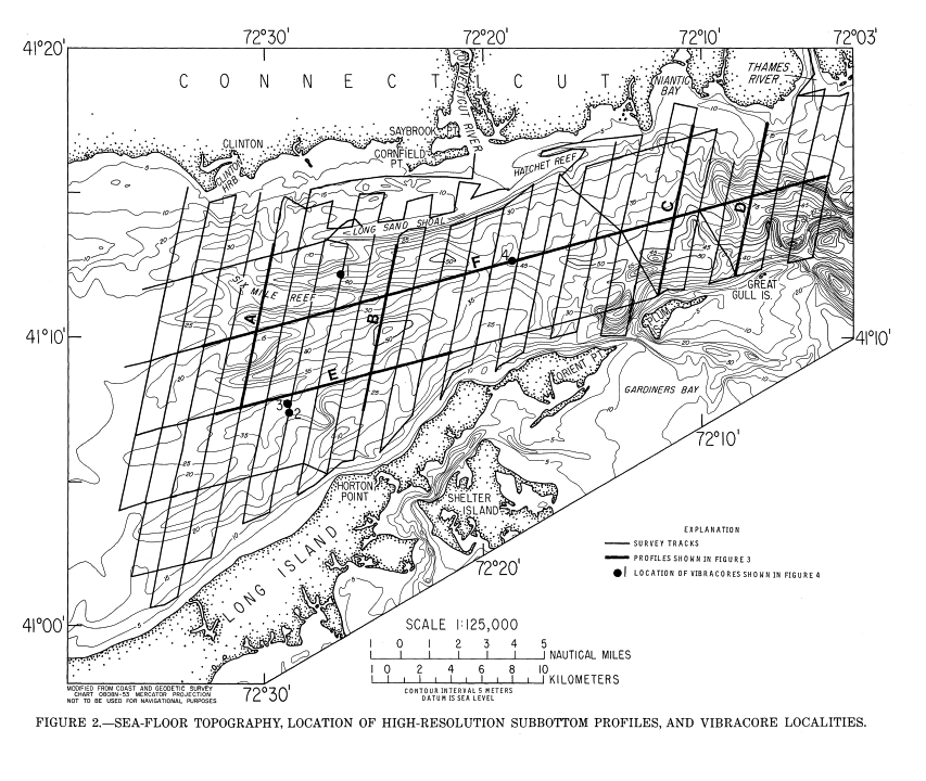

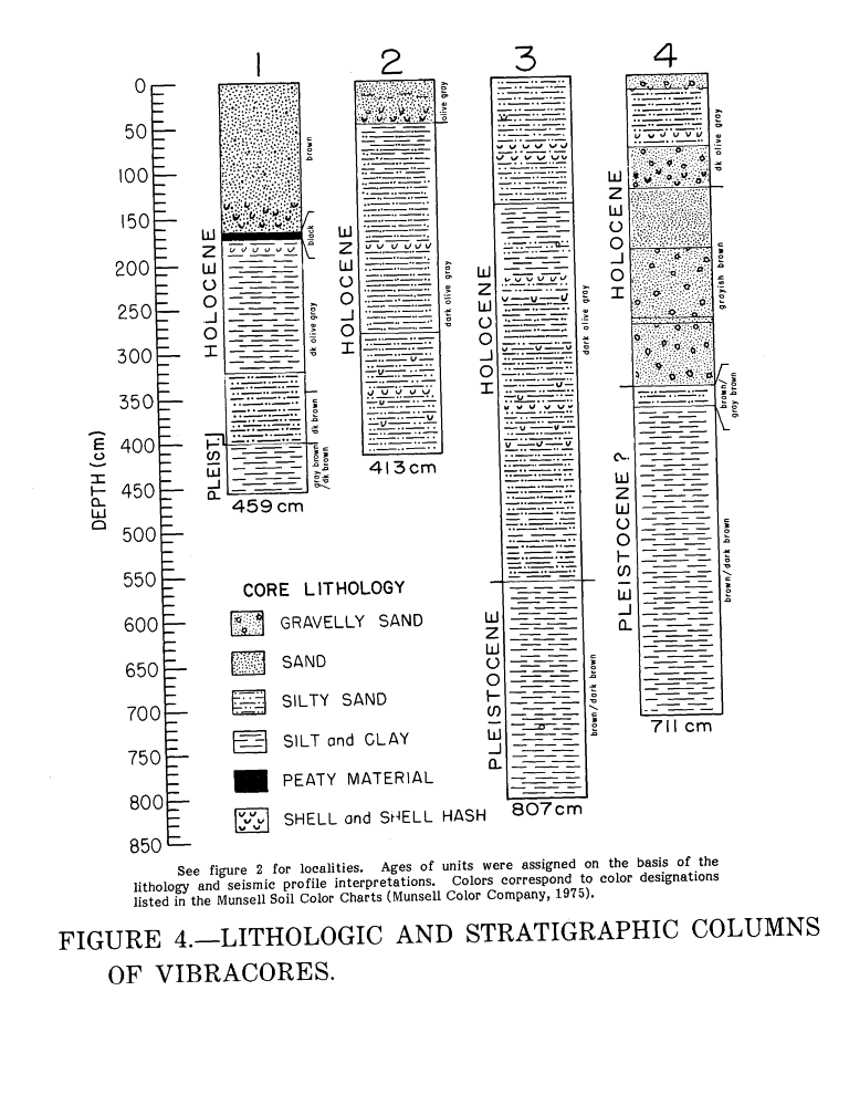
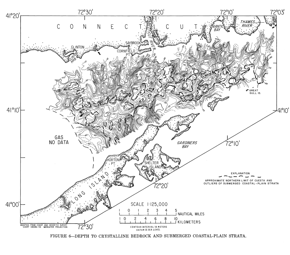
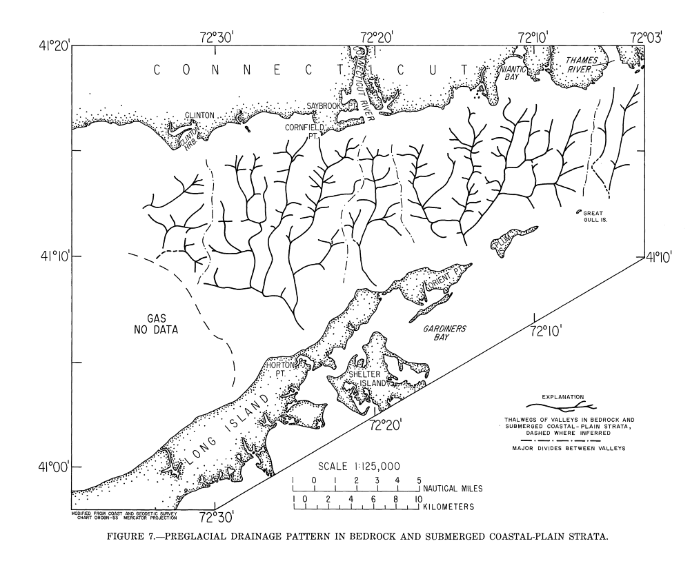
 Figure 9