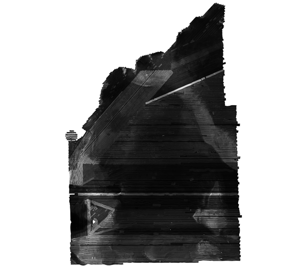
H11044_UTM18_WGS84.TIF: Composite sidescan sonar mosaic of NOAA survey H11044 in West-Central Long Island Sound off Milford, Connecticut (UTM Zone 18, WGS84)
H11044_UTM18_WGS84.TIF: Composite sidescan sonar mosaic of NOAA survey H11044 in West-Central Long Island Sound off Milford, Connecticut (UTM Zone 18, WGS84)
The U.S. Geological Survey, in cooperation with the National Oceanic and Atmospheric Administration and the Connecticut Department of Environmental Protection, has produced detailed geologic maps of the sea floor in Long Island Sound, a major East Coast estuary surrounded by the most densely populated region of the United States. These studies have built upon cooperative research with the State of Connecticut that was initiated in 1982. The current phase of this research program is directed toward studies of sea-floor sediment distribution, processes that control sediment distribution, nearshore environmental concerns, and the relation of benthic community structures to the sea-floor geology. Anthropogenic wastes, toxic chemicals, and changes in land-use patterns resulting from residential, commercial, and recreational development have stressed the environment of the Sound, causing degradation and potential loss of benthic habitats (Koppelman and others, 1976; Long Island Sound Study, 1994). Detailed maps of the sea floor are needed to help evaluate the extent of adverse impacts and to help manage resources wisely in the future. Therefore, in a continuing effort to better understand Long Island Sound, we have constructed and interpreted sidescan sonar mosaics (complete-coverage acoustic images of the sea floor) within specific areas of special interest. The mosaic presented herein covers an area of the sea floor in north-central Long Island Sound off Milford, Connecticut. The mosaics and their interpretations serve many purposes, including: (1) defining the geological variability of the sea floor, which is one of the primary controls of benthic habitat diversity; (2) improving our understanding of the processes that control the distribution and transport of bottom sediments and the distribution of benthic habitats and associated infaunal community structures; and (3) providing a detailed framework for future research, monitoring, and management activities. The sidescan sonar mosaics also serve as base maps for subsequent sedimentological, geochemical, and biological observations, because precise information on environmental setting is important for selection of sampling sites and for accurate interpretation of point measurements.
Purpose:
This GIS overlay is a component of the H11044 Survey, Long Island Sound, ArcView GIS database and contains the completed sidescan sonar mosaic for the study area. The image is projected in UTM and has not been enhanced. Light tones represent relatively harder returns, higher backscatter, and generally coarser sediments. Dark tones represent relatively softer returns, lower backscatter, and generally finer grained sediments.
Time_Period_of_Content:
Time_Period_Information:
Single_Date/Time:
Calendar_Date: 2001
Currentness_Reference: ground condition
Status:
Progress: Complete
Maintenance_and_Update_Frequency: None planned
Spatial_Domain:
Bounding_Coordinates:
West_Bounding_Coordinate: -72.869907
East_Bounding_Coordinate: -72.775833
North_Bounding_Coordinate: 41.237200
South_Bounding_Coordinate: 41.151200
Keywords:
Theme:
Theme_Keyword_Thesaurus: General
Theme_Keyword: U.S. Geological Survey
Theme_Keyword: USGS
Theme_Keyword: Coastal and Marine Geology Program
Theme_Keyword: CMGP
Theme_Keyword: Woods Hole Science Center
Theme_Keyword: WHSC
Theme_Keyword: National Oceanic and Atmospheric Administration
Theme_Keyword: NOAA
Theme_Keyword: NOAA Ship RUDE
Theme_Keyword: Connecticut Department of Environmental Protection
Theme_Keyword: CT-DEP
Theme_Keyword: geotiff
Theme_Keyword: ArcView
Theme_Keyword: sidescan sonar mosaic
Theme_Keyword: image
Theme:
Theme_Keyword_Thesaurus: ISO 19115 Topic Category
Theme_Keyword: oceans and estuaries
Theme_Keyword: geoscientificInformation
Theme_Keyword: imageryBaseMapsEarthCover
Place:
Place_Keyword_Thesaurus: General
Place_Keyword: Long Island Sound
Place_Keyword: Connecticut
Place_Keyword: Milford
Place_Keyword: northeast United States
Place_Keyword: U.S. East Coast
Place_Keyword: United States
Place_Keyword: North America
Place_Keyword: Atlantic Ocean
Place_Keyword: North Atlantic Ocean
Access_Constraints: None
Use_Constraints:
Public domain data are freely redistributable with proper metadata and source attribution. Please recognize the National Oceanic and Atmospheric Administration (NOAA) as the originator of this dataset.
Original sidescan sonar mosaic created by National Oceanic and Atmospheric Administration (NOAA). This image is projected in UTM to maintain the aspect ratio.
Process_Step:
Process_Description:
The sidescan sonar imagery contained in this report was produced from data collected during 2001 as part of NOAA survey H11044 aboard the NOAA Ship RUDE. The data for these surveys were acquired in XTF (extended Triton data format) using an Edgetech (EG&G) 272T sidescan sonar tow fish set to sweep about 100 m to either side of the ship's track. The Edgetech model 272T tow fish emits two 50°-wide beams tilted down 20° from horizontal, and transmits at 100 kHz. Analog side scan sonar data were converted to digital using an EG&G Analog Converter Interface (ACI). These digital data were then recorded through a Triton Elics International ISIS data acquisition system. The sidescan sonar data were multiplexed and filtered to convert the data into the desired processing format and to remove speckle noise and corrected for slant-range distortions, and imported into SonarWeb, an application that creates mosaics from raw XTF sidescan sonar data. The mosaic include the following standards: 1 meter resolution, image 'shine through', and auto contrast adjustment (with a 12.9% contrast increase). The final image was projected in Universal Transverse Mercator to maintain the aspect ratio.
Source_Used_Citation_Abbreviation: XTF sidescan sonar data
Although this data set has been used by the U.S. Geological Survey (USGS), Connecticut Department of Environmental Protection (CT-DEP), and the National Oceanic and Atmospheric Administration (NOAA), no warranty, expressed or implied, is made by the USGS or NOAA as to the accuracy of the data and/or related materials. The act of distribution shall not constitute any such warranty, and no responsibility is assumed by the USGS, CT-DEP, or NOAA in the use of these data or related materials.
Any use of trade, product, or firm names is for descriptive purposes only and does not imply endorsement by the U.S. Government.
Standard_Order_Process:
Digital_Form:
Digital_Transfer_Information:
Format_Name: TIFF
Format_Specification: GeoTIFF
Format_Information_Content:
A zip file containing the GeoTIFF image, world file and accompanying metadata file.
This image is available as a GEOTIFF image with an accompanying world file. To utilize this data, the user must have an image viewer, image processing or GIS software package capable of importing a GeoTIFF image.
Available_Time_Period:
Time_Period_Information:
Single_Date/Time:
Calendar_Date: 2005
Metadata_Reference_Information:
Metadata_Date: 20050823
Metadata_Contact:
Contact_Information:
Contact_Person_Primary:
Contact_Person: Lawrence J. Poppe
Contact_Organization: U.S. Geological Survey
Contact_Position: Geologist
Contact_Address:
Address_Type: mailing and physical address
Address: U.S. Geological Survey
Address: 384 Woods Hole Road
City: Woods Hole
State_or_Province: MA
Postal_Code: 02543-1598
Country: USA
Contact_Voice_Telephone: (508) 548-8700 x2314
Contact_Facsimile_Telephone: (508) 457-2310
Contact_Electronic_Mail_Address: lpoppe@usgs.gov
Metadata_Standard_Name: FGDC Content Standards for Digital Geospatial Metadata