|
|
Highlights of Time-Series Photographs
The time-series photographs obtained between December 1989 and September 2005 at LT-A in western Massachusetts Bay are published in Butman and others (2008a) and this publication (Butman and others, 2008b). These highlights refer to the time-series photographs included in both publications. See the Notes section for descriptions and explanations of some of the features and events in each set of time-series photographs included in this publication.
The sea floor in the area of tripod deployments in western Massachusetts Bay typically is covered by gravel, dominated by cobbles. Although tripod locations were within about 200 m of each other (fig. 8), the sea floor under each tripod is unique. The placement of the camera, strobe, and compass on the tripod frame differs slightly from deployment to deployment, and thus, each set of time-series photographs have different lighting and field of view. Each set of time-series photographs presents a unique view of approximately 1-square-meter area of the sea floor that shows changes in the sea floor, near-bottom water turbidity, and plants and animals.
Some of the photographs have characteristics or show changes that are a result of the unattended operation of the equipment on the ocean bottom. In some deployments, the lighting decreases with time owing to biological fouling of the strobe or a decrease in power from the strobe battery. In some deployments, the camera system, the oceanographic sensors, and (or) the controlling or recording electronics did not always function properly for the entire 4-month deployment, resulting in missing data. Some of the films have red marks or a red haze that is a result of light leaking from the LED in the data chamber and exposing the film (for example, records 591 and 767). The tripod frame was tipped on its side in some deployments, ending the photograph sequence or continuing the sequence with the camera focused on the water column. Sometimes the tripod was tipped by currents associated with storms (records 389 and 717) and sometimes apparently by entanglement with fishing gear (records 407, 428, and 775). In some instances, the currents during a storm were strong enough to shift the tripod on the sea floor, slightly changing the field of view of the camera (for example, records 495 (compare frames 259 and 291), 516 (compare frames 270 and 272), and 638 (compare frames 121 and 201)).
In almost all of the time-series sequences, movement of the surficial material (pebbles, cobbles, and shells) is observed during the deployment. This movement is best seen by playing the movie or by scrolling through the movie using the slidebar in the movie player; this viewing shows constant rearrangement of shells and pebble- to cobble-sized material on the sea floor. In some deployments, cobbles are rolled or overturned during periods with weak currents (for example, in record 400 (frames 417-418), record 430 (frames 663-664), record 462 (frames 399-400), and record 516 (frames 212-213; 441-442; 648-649)). The relative role of currents, waves and currents during storms, and biological activity in causing movement of the surficial material remains to be determined. However, the near bottom currents at LT-A are typically less than 0.2 m/s during non-storm periods, so much of the movement is hypothesized to be caused by biological activity. Although the results are observed in the time-series photographs, the role of particular animals cannot be documented with only one picture every 4 to 6 hours.
Animals and some plants appear in the photographs (see table 5 for identifications). Note that objects, such as fish, close to the camera lens appear larger than they are in relation to features on the bottom. In most cases, individual animals are observed in only one frame but some are observed in several frames spaced 4 to 6 hours apart. In some sequences, animals remain in nearly the same location for extended periods of time or sometimes return to the same location at a later time. For example, in record 338 a skate is observed in the same location (frames 116-125) for at least 48 hours. In record 383, a spiny sunstar is visible for 48 hours (frames 383-390). In record 420, a crab excavates a depression and remains in the depression for at least 12 hours (frames 011- 014). In record 445, a flounder occupies a depression for at least 12 hours (frames 155-157), then a nearby depression is occupied for at least 12 hours (frames 161-163), and finally the first depression is reoccupied for another 12 hours in frames 167 to 169 and again in frames 221 to 223. In record 450, two apparently different ocean pout are observed in nearly the same location, both for at least 8 hours (frames 493-494, and 495-496); later in the same deployment, a similar ocean pout is observed in nearly the same location (frames 657-658). These observations indicate that there may be preferred locations on the sea floor that are occupied for a period of time by the same animals, in the case of these observations typically 12 hours. The animals may find some shelter beneath the tripod frame, which encourages them to stay in the same location.
A major process illustrated in the photographs is the resuspension of sediments caused by oscillatory currents associated with surface waves, as indicated by the standard deviation of the bottom pressure. Increases in beam attenuation (indicating decreased water clarity) usually coincide with periods of increased waves and turbidity in the photographs. In many cases, there is enough material suspended in the water column that the sea floor is not visible. The sea floor in this region of Massachusetts Bay is covered mostly by cobbles, pebbles, and coarse sand; however, there are patches of fine-grained sediment to the west of this site (fig. 8), and a thin veneer of fine sediments is likely to accumulate at the tripod site during periods of low waves. These fine sediments are resuspended by the oscillatory currents associated with surface waves. Other observations and modeling indicate that fine sediment resuspended during storms with winds from the northeast in this part of western Massachusetts Bay is transported to the southeast toward the long-term depositional sites of Cape Cod Bay and Stellwagen Basin (fig. 1; Butman and others, 2007c, Warner and others, 2008).
|
Click on thumbnail below for figure in PDF format.
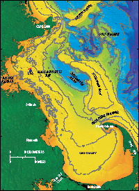 Figure 1.
Location of long-term mooring at LT-A in western Massachusetts Bay.
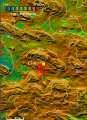 Figure 8.
Location of tripod moorings (over-lapping red triangles) at LT-A in western Massachusetts Bay deployed from 1989-2005.
 Table 5.
Identifications of animals and plants observed in the time-series photographs obtained at LT-A.
|