Commission, Cape Cod , 1997, CCNSSP1_GEO: Cape Cod National Seashore Park boundary: MassGIS, Boston, MA.This is part of the following larger work.Online Links:
- <http://www.mass.gov/mgis/>
- <http://www.mass.gov/mgis/ccc.htm>
- <http://www.capecodcommission.org/>
- <http://pubs.usgs.gov/of/2005/1048/data/basemaps/boundaries/ccnss/ccnssp1_geo.zip>
- <http://pubs.usgs.gov/of/2005/1048/htmldocs/data_catalog.htm>
Poppe, L.J., Paskevich, V.F., Butman, B., Valentine, P.C., Danforth, W.W., Foster, D.S., and Blackwood, D.S., 2006, Geological Interpretation of Bathymetric and Backscatter Imagery of the Sea Floor off Eastern Cape Cod, Massachusetts: Open-File Report 2005-1048, U.S. Geological Survey, Coastal and Marine Geology Program, Woods Hole Science Center, Woods Hole, MA.Online Links:
This is a Vector data set. It contains the following vector data types (SDTS terminology):
Horizontal positions are specified in geographic coordinates, that is, latitude and longitude. Latitudes are given to the nearest 0.000000. Longitudes are given to the nearest 0.000000. Latitude and longitude values are specified in Decimal degrees.
The horizontal datum used is North American Datum of 1983.
The ellipsoid used is Geodetic Reference System 80.
The semi-major axis of the ellipsoid used is 6378137.000000.
The flattening of the ellipsoid used is 1/298.257222.
Sequential unique whole numbers that are automatically generated.
Coordinates defining the features.
| Range of values | |
|---|---|
| Minimum: | 6190.930 |
| Maximum: | 111365400.000 |
| Resolution: | .001 |
| Range of values | |
|---|---|
| Minimum: | 298.953 |
| Maximum: | 178329.800 |
| Resolution: | .001 |
| Range of values | |
|---|---|
| Minimum: | 1.5 |
| Maximum: | 27519.4 |
| Units: | acres |
| Resolution: | .1 |
When using MassGIS data on maps or in digital applications, please credit the "Office of Geographic and Environmental Information (MassGIS), Commonwealth of Massachusetts Executive Office of Environmental Affairs" .Please credit the Cape Cod Commission for digitization and creation of the dataset.
(508) 362-3828 (voice)
(508) 362-3136 (FAX)
gis@capecodcommission.org
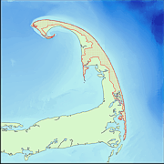
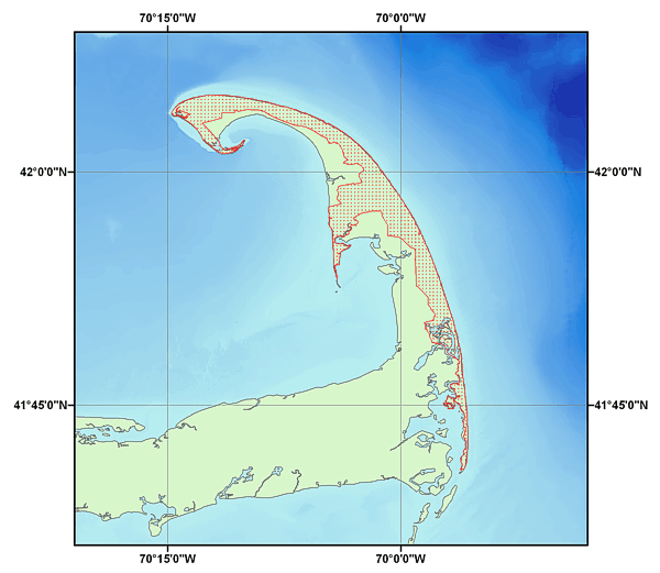
This data layer provides boundaries of the Cape Cod National Seashore Park.
Commission, Cape Cod , 1997, CCNSSP1: Cape Cod National Seashore Park boundary from parcel maps..Online Links:
Person who carried out this activity:
(508) 548-8700 x2281 (voice)
(508) 457-2310 (FAX)
vpaskevich@usgs.gov
Data sources produced in this process:
This data set is complete as it is a copy of the dataset available from the MassGIS website.
No additional checks for topological consistency were performed on the data.
Are there legal restrictions on access or use of the data?
- Access_Constraints: None
- Use_Constraints:
- Public domain data is freely redistributable with proper metadata and source attribution. Please recognize Office of Geographic and Environmental Information (MassGIS), Commonwealth of Massachusetts Executive Office of Environmental Affairs as the source of this data.
(617) 626-1000 (voice)
(617) 626-1249 (FAX)
Downloadable Data: Cape Cod National Seashore Boundary. The datum for this MassGIS data layer is North American Datum 1983 (NAD83). The data are registered to the Massachusetts State Plane Coordinate System, Mainland Zone (Fipszone 2001). Units are meters.
| Data format: | The SHP file contains the geospatial data. The SHX file contains the index of the geospatial data. The DBF file contains the attribute data in dBASE format. The PRJ file contains the coordinate system information (optional). The AVL file contains the legend information (optional). The SBN and SBX files contain the spatial index of the geospatial data (optional). The XML file contains the metadata describing the data set <data set name>.shp.xml. An ASCII version of the metadata file. A browse graphic showing the data layer coverage and extent (optional). in format SHP (version 3.3) ESRI Shapefile Size: 0.153 |
|---|---|
| Network links: |
<http://www.mass.gov/mgis/ccc.htm> |
These data are available in Environmental Systems Research Institute (ESRI) shapefile format. The user must have ArcGIS® or ArcView® 3.0 or greater software to read and process the data file. In lieu of ArcView or ArcGIS, the user may utilize another GIS application package capable of importing data. A free data viewer, ArcExplorer, capable of displaying the data is available from ESRI at www.esri.com.
(508) 548-8700 x2281 (voice)
(508) 457-2310 (FAX)
vpaskevich@usgs.gov
Downloadable Data: Cape Cod National Seashore Boundary
Although these data have been used by the U.S. Geological Survey, U.S. Department of the Interior, no warranty expressed or implied is made by the U.S. Geological Survey as to the accuracy of the data. The act of distribution shall not constitute any such warranty, and no responsibility is assumed by the U.S. Geological Survey in the use of this data.Any use of trade, product, or firm names is for descriptive purposes only and does not imply endorsement by the U.S. Government.
| Data format: | The SHP file contains the geospatial data. The SHX file contains the index of the geospatial data. The DBF file contains the attribute data in dBASE format. The PRJ file contains the coordinate system information (optional). The AVL file contains the legend information (optional). The SBN and SBX files contain the spatial index of the geospatial data (optional). The XML file contains the metadata describing the data set < data set name>.shp.xml. An ASCII version of the metadata file. A browse graphic showing the data layer coverage and extent (optional). in format SHP (version 3.3) ESRI Shapefile Size: 0.153 |
|---|---|
| Network links: |
<http://pubs.usgs.gov/of/2005/1048/data/basemaps/boundaries/ccnss/ccnssp1_geo.zip> <http://pubs.usgs.gov/of/2005/1048/htmldocs/data_catalog.htm> <http://pubs.usgs.gov/of/2005/1048/data/basemaps/boundaries/ccnss/> |
| Media you can order: |
DVD-ROM
(Density 4.75
Gbytes)
(format UDF)
|
These data are available in Environmental Systems Research Institute (ESRI) shapefile format. The user must have ArcGIS® or ArcView® 3.0 or greater software to read and process the data file. In lieu of ArcView or ArcGIS, the user may utilize another GIS application package capable of importing data. A free data viewer, ArcExplorer, capable of displaying the data is available from ESRI at www.esri.com.
(508) 548-8700 x2281 (voice)
(508) 457-2310 (FAX)
vpaskevich@usgs.gov