Woods Hole Science Center
U.S. Geological Survey Open-File Report 2005-1048
Geological Interpretation of Bathymetric and Backscatter Imagery of the Sea Floor Off Eastern Cape Cod, Massachusetts
GEOLOGIC SETTING
|
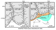
The geology of outer Cape Cod is a product of glacial processes during the late Wisconsinan part of the Pleistocene Epoch and a storm and tidally dominated marine regime during the Holocene sea-level rise. The late Wisconsinan Laurentide ice sheet reached its maximum extent and southernmost position about 20 ka, as marked by terminal moraines on Martha’s Vineyard and Nantucket and the southern limit of abundant gravel on the adjacent sea floor (Schlee and Pratt, 1970; Oldale, 1992; Uchupi and others, 1996; Figure 2A). This lobate ice front was formed by the Buzzards Bay lobe that deposited the moraine along the western part of Martha’s Vineyard, the Cape Cod Bay lobe that deposited the moraines across eastern Martha’s Vineyard and Nantucket, and the South Channel lobe that extended east toward Georges Bank (Oldale and Barlow, 1986; Oldale, 1992). Shortly prior to 18 ka, the ice sheet had retreated and the Buzzards Bay lobe occupied a position west of the Elizabeth Islands, the Cape Cod Bay lobe a position along the northern edge of Cape Cod, and the Great South Channel lobe to just north of Great South Channel (Larson, 1982; Uchupi and others, 1996; Figure 2B). About this time the main part of Cape Cod was deposited as the Barnstable outwash plain and a glacial lake occupied Nantucket Sound. The rate of the lobes’ retreat varied. Deposits associated with the Buzzards Bay lobe are oldest; deposits associated with the Great South Channel lobe are youngest (Oldale and O’Hara, 1984; Oldale, 1992). Just after 18 ka, continued retreat of the ice fronts positioned the Buzzards Bay lobe northwest of Buzzards Bay, the Cape Cod Bay lobe in the center of Cape Cod Bay, and the Great South Channel lobe northward and eastward, creating an intervening low between itself and the Cape Cod Bay lobe (Uchupi and others, 1996; Figure 3).
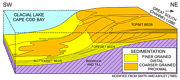
As the Cape Cod Bay lobe retreated, meltwaters dammed to the south by the Sandwich moraine on Cape Cod and to the east by the Great South Channel lobe formed a proglacial lake, Glacial Lake Cape Cod Bay (Larson, 1982; Oldale, 1992). Sediments transported by meltwater streams flowing westward and southwestward into this lake from the South Channel lobe created three large deltas that, in order of age, constitute the Wellfleet, Truro, and Eastham outwash plains (Masterson, 2004). Coarser grained deposits within these deltas primarily record higher energy proximal environments and probably represent topset beds; finer grained deposits within these deltas primarily record lower energy distal environments and probably represent bottomset beds (Figure 4).
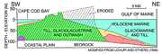
The Holocene marine transgression conspicuously modified the outer Cape. Prior to 6 ka, massive erosion of the east side of Cape Cod produced sediment that filled in a depression at the elbow of the Cape. Because Georges Bank was still exposed, it partially blocked long-period waves from the east and southeast, but not northeast, resulting in net sediment transport toward the south (Ziegler and others, 1964; Ziegler and others, 1965). After Georges Bank was finally submerged about 6 ka, waves were no longer blocked, northward sediment transport became more pronounced and the construction of the Provincetown Hook began (Ziegler and others, 1965; Uchupi and others, 1996). Since the Holocene transgression began, much of the deltaic sediment constituting the outer Cape has been eroded (Figure 5). Uchupi and others (1996) estimate the original eastward facing scarp was up to 7.0 km farther east than the modern shoreline. Remaining outwash deposits, which presumably overlie crystalline Paleozoic rocks layered with basal till, are 125-150 m thick (Oldale and Tuttle, 1964; Oldale, 1969). Presently, the littoral drift along the outer Cape diverges near Nauset. Sediment to the north is transported along the coast toward the Provincetown Hook; sediment to the south is transported toward Monomoy Island. Construction of the Provincetown Hook and Monomoy Island and erosion of outwash plains exposed to the Atlantic Ocean continues. The east-facing bluffs formed by the outwash plains are retreating at rates greater than 2 m/yr (Oldale, 1992). |