Woods Hole Science Center
U.S. Geological Survey Open-File Report 2005-1048
Geological Interpretation of Bathymetric and Backscatter Imagery of the Sea Floor Off Eastern Cape Cod, Massachusetts
MAPS
|
PDF Maps of Imagery and Interpretations Five sets of maps displaying the backscatter, shaded relief bathymetry and pseudo-colored backscatter imagery, and sedimentary environment and surficial sediment distribution interpretations are available for downloading, viewing and printing. Interpretations of the distributions of surficial sediment and sedimentary environments are based on bathymetry, tonal changes in backscatter, sediment samples and bottom photography. All contacts should be considered to be inferred. Boundaries between sediment types and environments are typically gradational and are seldom abrupt.Individuals interested in printing hardcopies of the maps can access their selection from the tables below. Because of their geographic extent, the maps have been divided into northern and southern parts and plot at a scale of 1:45,000 on 35x45-inch sheets.
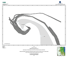
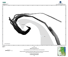
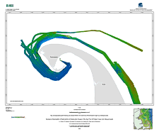
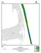
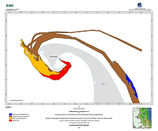
Sun-Illuminated BathymetryThe sun-illuminated bathymetry shown in the multibeam sonar image is vertically exaggerated two times and artificially illuminated by a light source positioned 45 degrees above the horizon from an azimuth of 350 degrees. Therefore, north-facing slopes receive stronger illumination and have lighter tones; south-facing slopes are in shadows, receive weaker illumination, and have darker tones. Minimum horizontal resolution (i.e. pixel size) on this imagery is 4 m.
BackscatterBackscatter intensity is a measure of sea-floor hardness and roughness as determined by the strength of the sound waves reflected from the seabed during the survey. Lighter tones represent higher backscatter, harder sea floor, and generally coarser grained sediments. Darker tones represent lower backscatter, softer sea floor, and generally finer grained sediments.
Pseudo-Color Coded BackscatterThe pseudo-colored imagery combines sun-illuminated topography with backscatter intensity. Here the backscatter intensity is depicted by a suite of eight colors ranging from red, which represents high intensity (hard bottom and generally coarser sediments), to blue, which represents low intensity (soft bottom and generally finer sediments). These backscatter intensity data are draped over the sun illuminated imagery described above, resulting in an image that displays dark and light tones within each color band that are determined by a feature's position with respect to the light source. For example, north-facing slopes receive stronger illumination and have lighter tones within a color band; south-facing slopes are in shadows, receive weaker illumination, and have darker tones.
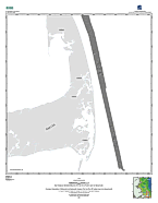
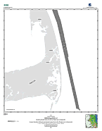
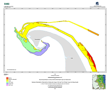
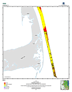
Surficial Sediment DistributionSurficial sediments are important because they reflect the energy of the environment and are an important controlling factor on the distribution of benthic habitats. Interpretations of the surficial sediment distribution are based on the grade scale of Wentworth (1922) and the ternary sediment classification scheme of Shepard (1954), as modified by Schlee (1973). Warm colors in the color scheme are coarser sediments; cooler colors are finer grained sediments. Polygons show the sediment type interpreted to be dominant or most common for that area of the sea floor. However, it is important to note that the sea floor off outer Cape Cod is extremely variable and that within any given polygon other sediment types are present.
Sedimentary EnvironmentFour categories of sedimentary environments are present off outer Cape Cod and they reflect the dominant long-term processes of: erosion or nondeposition, coarse-grained bedload transport, sediment sorting and reworking, and fine-grained deposition. Environments characterized by erosion or nondeposition contain exposures of glacial drift and coarse lag deposits and include sediments which range from boulder fields to gravelly sands. Environments characterized by coarse bedload transport are covered by sand waves and megaripples and contain coarse to medium sands and only small amounts of mud. Environments characterized by sorting and reworking contain variable amounts of sand and mud. Environments characterized by deposition are blanketed by mud.
|