USGS Open File Report 2005-1066

ctd_02 - Oceanographic Data Device Location for Joint USGS Cruise 02051 and NOAA RB0208

Metadata also available as: - [Questions & Answers] - [Parseable text] - [XML]

Metadata:


Identification_Information:
Citation:
Citation_Information:
Originator: National Oceanic and Atmospheric Administration (NOAA)
Originator: U.S. Geological Survey (USGS)
Publication_Date: 2005
Title:
ctd_02 - Oceanographic Data Device Location for Joint USGS Cruise 02051 and NOAA RB0208
Edition: 1.0
Geospatial_Data_Presentation_Form: vector digital data
Series_Information:
Series_Name: Open-File Report
Issue_Identification: 2005-1066
Publication_Information:
Publication_Place: Woods Hole Science Center, Woods Hole, MA
Publisher: U.S. Geological Survey, Coastal and Marine Geology Program
Online_Linkage: <http://pubs.usgs.gov/of/2005/1066/data/oceanography/ctd/ctd.zip>
Larger_Work_Citation:
Citation_Information:
Originator: Uri ten Brink
Originator: Lt. Shep Smith
Originator: Chuck Worley
Originator: Thomas Stepka
Originator: Glynn Williams
Publication_Date: 2005
Title:
Project PROBE Leg I - Report and Archive of Multibeam Bathymetry and Acoustic Backscatter, CTD/XBT and GPS Navigation Data Collected During USGS Cruise 02051 (NOAA Cruise RB0208) Puerto Rico Trench, September 24, 2002 to September 30, 2002.
Edition: 1.0
Series_Information:
Series_Name: Open-File Report
Issue_Identification: 2005-1066
Publication_Information:
Publication_Place: Woods Hole Science Center, Woods Hole, MA
Publisher: U.S. Geological Survey, Coastal and Marine Geology Program
Other_Citation_Details: 1 DVD-ROM
Online_Linkage: <http://pubs.usgs.gov/of/2005/1066>
Description:
Abstract:
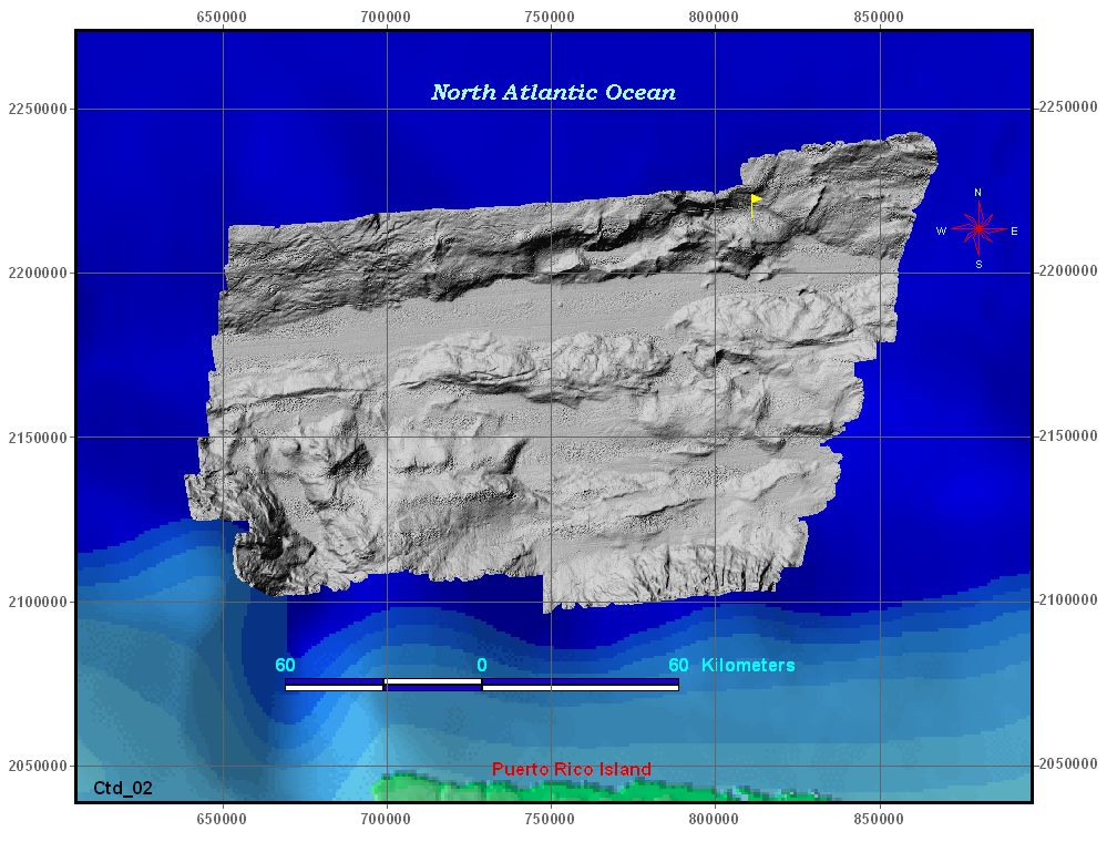
This data set shows a location where the CTD (Conductivity -Temperature - Depth) device was used. CTD were determined while in the Caribbean Sea during the USGS Science Cruise 02051 in collaboration with NOAA Research Cruise RB0208 from 24 September to 30 September 2002, Leg I of III. The point location attributes are longitude, latitude, and date of placement in the water. It is in Environmental Science Research Institution (ESRI) shapefile format, geometric point data.
Purpose:
To derive sound velocity information to be used for sonar mapping calibration and to determine some water characteristics
Time_Period_of_Content:
Time_Period_Information:
Range_of_Dates/Times:
Beginning_Date: 20020924
Ending_Date: 20020930
Currentness_Reference: ground condition
Status:
Progress: Complete
Maintenance_and_Update_Frequency: None planned
Spatial_Domain:
Bounding_Coordinates:
West_Bounding_Coordinate: -66.011000
East_Bounding_Coordinate: -66.011000
North_Bounding_Coordinate: 20.058500
South_Bounding_Coordinate: 20.058500
Keywords:
Theme:
Theme_Keyword_Thesaurus: General
Theme_Keyword: USGS
Theme_Keyword: CMGP
Theme_Keyword: NOAA
Theme_Keyword: ocean temperature
Theme_Keyword: locations
Theme_Keyword: point shapefile
Theme_Keyword: USGS Cruise 02051
Theme_Keyword: NOAA Cruise RB0208
Theme_Keyword: National Oceanic and Atmospheric Administration
Theme_Keyword: Coastal and Marine Geology Program
Theme_Keyword: U.S. Geological Survey
Theme_Keyword: Conductivity Temperature Depth
Theme_Keyword: Woods Hole Science Center
Theme_Keyword: WHSC
Place:
Place_Keyword_Thesaurus: General
Place_Keyword: North America
Place_Keyword: North Atlantic Ocean
Place_Keyword: Puerto Rico
Place_Keyword: US Possessions
Place_Keyword: US Caribbean Island
Place_Keyword: Atlantic Ocean
Place_Keyword: Caribbean Sea
Place_Keyword: Puerto Rico Trench
Access_Constraints: None
Use_Constraints:
Public domain data from the U.S. government are freely redistributable with proper metadata and source attribution. Please recognize the U.S. Geological Survey as the originator of this data set.
Point_of_Contact:
Contact_Information:
Contact_Person_Primary:
Contact_Person: Glynn Williams
Contact_Organization: U.S. Geological Survey
Contact_Position: Information Technician (Geo/GIS)
Contact_Address:
Address_Type: mailing and physical address
Address: 384 Woods Hole Road
City: Woods Hole
State_or_Province: MA
Postal_Code: 02543-1598
Country: USA
Contact_Voice_Telephone: (508) 548-8700 x2290
Contact_Facsimile_Telephone: (508) 457-2310
Contact_Electronic_Mail_Address: gwilliams@usgs.gov
Hours_of_Service: 8:00AM to 5:00PM; M-F
Native_Data_Set_Environment:
Microsoft Windows XP Version 5.1 (Build 2600) Service Pack 2; ESRI ArcCatalog 9.0.0.535
Cross_Reference:
Citation_Information:
Originator: Uri ten Brink
Originator: William Danforth
Originator: Chris Polloni
Originator: Castle Eugene Parker
Originator: Toshi Uozumi
Originator: Glynn Williams
Publication_Date: 2004
Title:
Project PROBE Leg II - Final Report and Archive of Swath Bathymetric Sonar, CTD/XBT and GPS Navigation Data Collected During USGS Cruise 03008 (NOAA Cruise RB0303) Puerto Rico Trench 18 February - 7 March, 2003
Edition: 1.0
Series_Information:
Series_Name: Open-file Report
Issue_Identification: 2004-1400
Publication_Information:
Publication_Place: Woods Hole Science Center, Woods Hole, MA
Publisher: U.S. Geological Survey, Coastal and Marine Geology Program
Other_Citation_Details: 1 DVD-ROM
Online_Linkage: <http://pubs.usgs.gov/of/2004/1400/>

Data_Quality_Information:
Positional_Accuracy:
Horizontal_Positional_Accuracy:
Horizontal_Positional_Accuracy_Report:
The GPS was considered to have a horizontal accuracy of < 10 meters.
Vertical_Positional_Accuracy:
Lineage:
Source_Information:
Source_Time_Period_of_Content:
Process_Step:
Process_Description:
The CTD data file was received from the R/V Ron Brown Oceanographic data network, sent directly to the central storage system and logged to a spreadsheet file.
Process_Date: 2002
Process_Contact:
Contact_Information:
Contact_Person_Primary:
Contact_Person: Lt. Shep Smith
Contact_Organization: Office of Marine and Aviation Operations (OMAO)
Contact_Position: Hydrographer
Contact_Address:
Address_Type: mailing address
Address: 1315 East West Highway
City: Silver Springs
State_or_Province: MD
Postal_Code: 20910
Country: USA
Contact_Voice_Telephone: (301) 713-3431
Process_Step:
Process_Description:
The CTD spreadsheet file was reformatted as table input file for ArcView.
Process_Date: 2005
Process_Contact:
Contact_Information:
Contact_Person_Primary:
Contact_Person: Glynn Williams
Contact_Organization: U.S. Geological Survey
Contact_Position: Information Technician (Geo/GIS)
Contact_Address:
Address_Type: mailing and physical address
Address: 384 Woods Hole Road
City: Woods Hole
State_or_Province: MA
Postal_Code: 02543-1589
Country: USA
Contact_Voice_Telephone: (508) 548-8700 x2290
Contact_Facsimile_Telephone: (508) 457-2310
Contact_Electronic_Mail_Address: gwilliams@usgs.gov
Hours_of_Service: 8AM to 5PM; M-F
Process_Step:
Process_Description:
CTD table location file saved as ArcView shapefile. ArcView 3.2 used to process shapefile.
Process_Date: 2005
Source_Produced_Citation_Abbreviation: ctd_02.dbf
Source_Produced_Citation_Abbreviation: ctd_02.shp
Source_Produced_Citation_Abbreviation: ctd_02.shx
Source_Produced_Citation_Abbreviation: ctd_02.prj
Source_Produced_Citation_Abbreviation: ctd_02.sbn
Process_Contact:
Contact_Information:
Contact_Person_Primary:
Contact_Person: Glynn Williams
Contact_Organization: U.S. Geological Survey
Contact_Position: Information Technician (Geo/GIS)
Contact_Address:
Address_Type: mailing and physical address
Address: 384 Woods Hole Road
City: Woods Hole
State_or_Province: MA
Postal_Code: 02543-1589
Country: USA
Contact_Voice_Telephone: (508) 548-8700 x2290
Contact_Facsimile_Telephone: (508) 457-2310
Contact_Electronic_Mail_Address: gwilliams@usgs.gov
Hours_of_Service: 8AM to 5PM; M-F
Process_Step:
Process_Description: CTD shapefile dataum change from NAD 1983 to WGS 1984
Process_Date: 2005
Process_Contact:
Contact_Information:
Contact_Person_Primary:
Contact_Person: Glynn Williams
Contact_Organization: U.S. Geological Survey
Contact_Position: Information Technician (Geo/GIS)
Contact_Address:
Address_Type: physical address
Address: 384 Woods Hole Road
City: Woods Hole
State_or_Province: MA
Postal_Code: 02543-1598
Country: USA
Contact_Voice_Telephone: 508-548-8700 x2290
Contact_Facsimile_Telephone: 508-457-2310
Contact_Electronic_Mail_Address: gwilliams@usgs.gov
Hours_of_Service: 8:00AM to 4:30PM; M-F

Spatial_Data_Organization_Information:
Direct_Spatial_Reference_Method: Vector
Point_and_Vector_Object_Information:
SDTS_Terms_Description:
SDTS_Point_and_Vector_Object_Type: Entity point
Point_and_Vector_Object_Count: 1

Spatial_Reference_Information:
Horizontal_Coordinate_System_Definition:
Geographic:
Latitude_Resolution: 0.000001
Longitude_Resolution: 0.000001
Geographic_Coordinate_Units: Decimal degrees
Geodetic_Model:
Horizontal_Datum_Name: D_WGS_1984
Ellipsoid_Name: WGS_1984
Semi-major_Axis: 6378137.000000
Denominator_of_Flattening_Ratio: 298.257224
Vertical_Coordinate_System_Definition:
Altitude_System_Definition:
Depth_System_Definition:

Entity_and_Attribute_Information:
Detailed_Description:
Entity_Type:
Entity_Type_Label: ctd_02
Entity_Type_Definition: Shapefile Attribute Table
Entity_Type_Definition_Source: ESRI
Attribute:
Attribute_Label: FID
Attribute_Definition: Internal feature number.
Attribute_Definition_Source: ESRI
Attribute_Domain_Values:
Unrepresentable_Domain:
Sequential unique whole numbers that are automatically generated.
Attribute:
Attribute_Label: Shape
Attribute_Definition: Feature geometry.
Attribute_Definition_Source: ESRI
Attribute_Domain_Values:
Unrepresentable_Domain: Coordinates defining the features.
Attribute:
Attribute_Label: ID
Attribute_Definition: A unique sequential number assigned to a particular object.
Attribute_Definition_Source: Software computed
Attribute:
Attribute_Label: LATITUDE
Attribute_Definition:
The north/south coordinate system reference point (location) where the CTD device was cast into water.
Attribute_Definition_Source: NOAA shipboard technician
Attribute_Domain_Values:
Range_Domain:
Range_Domain_Minimum: 19.0000
Range_Domain_Maximum: 19.6166
Attribute_Units_of_Measure: decimal degrees
Attribute_Measurement_Resolution: 0.0001
Attribute:
Attribute_Label: LONGITUDE
Attribute_Definition:
The east/west coordinate system reference point (location) where the XBT device was launched into water.
Attribute_Definition_Source: NOAA shipboard technician
Attribute_Domain_Values:
Range_Domain:
Range_Domain_Minimum: -62.83330
Range_Domain_Maximum: -68.40000
Attribute_Units_of_Measure: decimal degrees
Attribute_Measurement_Resolution: 0.00001
Attribute:
Attribute_Label: WAYPTS
Attribute_Definition:
Name assigned to designate CTD placement in water location for device.
Attribute_Definition_Source: USGS
Attribute_Domain_Values:
Enumerated_Domain:
Enumerated_Domain_Value: CTD
Enumerated_Domain_Value_Definition: Conductivity, Temperature, and Density Device
Enumerated_Domain_Value_Definition_Source: USGS
Attribute:
Attribute_Label: TIME
Attribute_Definition:
The recorded time when the device/equipment was launched into the water. Value Recorded as Universal Time Coordinated (UTC).
Attribute_Definition_Source: USGS
Attribute_Domain_Values:
Unrepresentable_Domain: Character string in the form of hh:mm:ss
Attribute:
Attribute_Label: DATE_
Attribute_Definition:
The recorded date when the device/equipment was launched into the water.
Attribute_Definition_Source: USGS
Attribute_Domain_Values:
Unrepresentable_Domain: Character string in the form of mmddyyy
Overview_Description:

Distribution_Information:
Distributor:
Contact_Information:
Contact_Person_Primary:
Contact_Person: Uri ten Brink
Contact_Organization: U.S. Geological Survey
Contact_Position: Research Geologist
Contact_Address:
Address_Type: mailing and physical address
Address: 384 Woods Hole Road
City: Woods Hole
State_or_Province: MA
Postal_Code: 02543-1589
Country: USA
Contact_Voice_Telephone: (508) 548-8700 x2396
Contact_Facsimile_Telephone: (508) 457-2310
Contact_Electronic_Mail_Address: utenbrink@usgs.gov
Hours_of_Service: 8AM to 5PM; M-F
Resource_Description: Downloadable Data: Open-File Report 2005-1066 - ctd_02
Distribution_Liability:
Although these data sets are used by the National Oceanic and Atmospheric Administration (NOAA) and the U.S. Geological Survey (USGS), no warranty, expressed or implied, is made by NOAA or the USGS as to the accuracy of the data and/or related materials. The act of distribution shall not constitute any such warranty, and no responsibility is assumed by NOAA or the USGS in the use of these data.
Standard_Order_Process:
Digital_Form:
Digital_Transfer_Information:
Format_Name: ArcView shapefile
Format_Version_Number: 3.2
Format_Specification: point shapefile
Format_Information_Content:
The individual files that comprise the shapefiles: ctd_02.dbf, ctd_02.prj, ctd_02.shp, ctd_02.shx
File_Decompression_Technique: zip
Transfer_Size: 7
Digital_Transfer_Option:
Offline_Option:
Offline_Media: DVD-ROM
Recording_Capacity:
Recording_Density: 4,700
Recording_Density_Units: Mbyte
Recording_Format: UDF
Compatibility_Information:
The user must have a computer system with a DVD-ROM available. To browse the information contained on this DVD-ROM, the user must have a current WWW browser available. The user must also have software installed on their computer to unzip the archived file.
Fees: none
Technical_Prerequisites:
The data is available in Environmental Systems Research Institute, Inc. (ESRI) shapefile format. The user must have ArcView 3.+ or ArcGIS 8.+ to read and process the data file. In lieu of ArcView/ArcGIS, the user may utilize another GIS application package capable of importing data.

Metadata_Reference_Information:
Metadata_Date: 20050504
Metadata_Review_Date: 20050825
Metadata_Contact:
Contact_Information:
Contact_Person_Primary:
Contact_Person: Glynn Williams
Contact_Organization: U.S. Geological Survey
Contact_Position: Information Technician (Geo/GIS)
Contact_Address:
Address_Type: physical address
Address: 384 Woods Hole Road
City: Woods Hole
State_or_Province: MA
Postal_Code: 02543-1598
Country: USA
Contact_Voice_Telephone: (508) 548-8700 x2290
Contact_Facsimile_Telephone: (508) 457-2310
Contact_Electronic_Mail_Address: gwilliams@.usgs.gov
Hours_of_Service: 8:00AM to 5:00PM; M-F
Metadata_Standard_Name: FGDC Content Standards for Digital Geospatial Metadata
Metadata_Standard_Version: FGDC-STD-001-1998
Metadata_Time_Convention: local time
Metadata_Access_Constraints: None
Metadata_Use_Constraints: None
Metadata_Extensions:
Online_Linkage: <http://www.esri.com/metadata/esriprof80.html>
Profile_Name: ESRI Metadata Profile

Generated by mp version 2.8.6 on Fri Aug 26 14:42:51 2005