USGS - science for a changing world

USGS Coastal and Marine Geology Program

GIS of Selected Geophysical and Core Data in the Northern Gulf of Mexico Continental Slope Collected by the U.S. Geological Survey

OF 2005-1071 Home

Overview

Geologic Findings

GIS Data Catalog

References Cited

Acknowledgements

Contacts

Disclaimer

An image showing contour lines indicating estimated thickness of the hydrate stability zone.

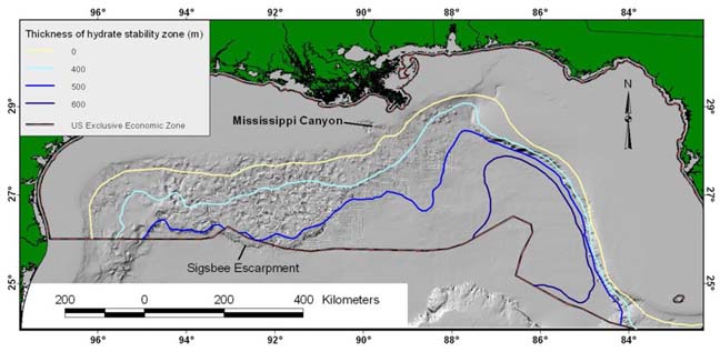
Figure 5. Estimated thickness of the hydrate stability zone in the Gulf of Mexico which was compiled by Collett (1995) as part of an assessment of gas hydrates within the US Exclusive Economic Zone. The information used for this assessment was published by Charpentier and others (1996), and all the shapefiles are included in the “Assessment— directory of this GIS.

Skip Navigation

Accessibility FOIA Privacy Policies and Notices

U.S. Department of the Interior | U.S. Geological Survey | Coastal and Marine Geology

URL: cmgds.marine.usgs.gov/publications/of2005-1071/htmldocs/figure5.htm
Page Contact Information: CMGDS Team
Page Last Modified: Wednesday, 06-Dec-2017 12:38:18 EST