
|
Interpolated Multibeam Bathymetry
H11043
The sea floor in the central and southern parts of the H11043 survey area has a relatively smooth gradient that slopes gradually toward the south-southeast (fig. 7). However, the sea floor in the northern part of the study area is more complex. Two isolated bathymetric highs, Townshend Ledge and Branford Reef, occur in the northwestern and northeastern parts of the study area, respectively. These bathymetric highs are composed of reworked glacial materials that represent the offshore continuation of the Madison moraine (Flint and Gebert, 1976; Needell and others, 1987). Water depths in the study area range from less than 2 m on the crest of Branford Reef and less than 6 m on the crest of Townshend Ledge to more than 26 m in the southeast corner. Townshend Ledge rises about 10 m over the surrounding sea floor which progressively shallows toward the northwest. Branford Reef rises about 8 m above the adjacent sea floor, but is flanked by shallow, isolated, east-west trending elongate depressions on its northern and southern sides. These depressions presumably result from scour by tidal currents.
|
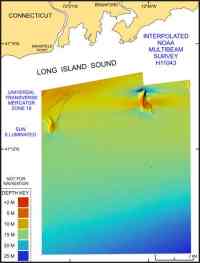 |
| Figure 7. Image shows the interpolated and regridded multibeam bathymetry from NOAA survey H11043 in north-central Long Island Sound off Branford, Ct. Click on figure for larger image. |
|
H11044
Two shoal complexes, Stratford Shoal Middle Ground and a larger unnamed shoal south of Stratford Point, Connecticut, make up the west-central and northwestern parts of the study area, respectively. Stratford Shoal Middle Ground rises over 20 m from the surrounding sea floor. The shoal off Stratford Point and northern parts of Stratford Shoal Middle Ground are composed of glaciolacustrine deltaic sediments, while southern parts of Stratford Shoal are probably composed of coastal-plain deposits (Lewis and DiGiacomo-Cohen, 2000). The shoals are separated by an east-west trending axial trough, which is the deepest feature in the study area, with water depths reaching 52 m. The northeastern corner of the mosaic contains a northwest-southeast trending elongate bathymetric high, which is about 2-6 m in height, 1.5 km wide, and extends for a length of 11 km within the study area. This bathymetric ridge is composed of ice-proximal glaciolacustrine fan deposits (Lewis and Stone, 1991). The southeastern corner of the study area contains two isolated bathymetric highs, probably cored by coastal plain deposits (Lewis and DiGiacomo-Cohen, 2000), rising about 5 m above the surrounding sea floor. An east-west trending trough reaching depths of 45 m cuts between the two highs. The south-central section of the study area borders on a small, elongate basin with an east-west trend and a slightly steeper gradient.
Most of the sea floor in the H11044 survey area slopes gently to the southeast or south; however, more complex bathymetry consisting of shoals, lesser bathymetric highs, and troughs are present in the western, southern, and northeastern parts of the study area (fig. 8). Water depths in the study area range from 3 m near the Connecticut coastline to over 50 m in troughs.
|
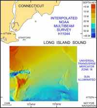 |
| Figure 8. Image shows the interpolated and regridded multibeam bathymetry from NOAA survey H11044 in north-central Long Island Sound off Milford, Ct. Click on figure for larger image. |
|
H11045
The shallowest parts of survey H11045 lie along its northern edge where depths are less than 5 m, largely on shoals off Shoal Point near Fairfield and off Stratford Point near Lordship, Connecticut (fig. 9). The shoal off Stratford Point has been interpreted to be composed of ice-marginal glaciolacustrine deltaic deposits associated with an ice position influenced by the Norwalk Islands moraine, to the west and the Old Saybrook moraine, to the east (Lewis and DiGiacomo-Cohen, 2000). Bathymetric variability on these shoals, especially on the shoal off Stratford, is related to the presence of sand waves which range up to 3.5 m high. The sea floor throughout most of the survey area dips relatively gently toward its southern edge where depths are about 35 m. Exceptions include an isolated bathymetric high located west of the Bridgeport Harbor entrance channel, southeast of Shoal Point, and two depressions present along the eastern edge of the survey area. The depressions exceed 50 m and 44 m and mark the entrance to east-west trending troughs that lie just north and south of Stratford Shoal Middle Ground, respectively. Constriction of the tidal flow by Stratford Shoal Middle Ground results in increased current speeds and environments characterized by erosion or non-deposition within the troughs. Isolated bathymetric highs, which rise 2-6 m above the surrounding sea floor and lie just west of these depressions, are probably tidal deltas. A bathymetric low in the southwestern part of the survey area is probably related to tidal current constriction within a trough that lies south of a bathymetric high off Norwalk, Connecticut.
Anthropogenic artifacts discernable in the bathymetry of survey H11045 include the Bridgeport Harbor entrance channel, which is dredged to over 8 m, and disposal mounds that are part of a discontinued dumping ground located 3-4 km south-southwest of the harbor channel.
|
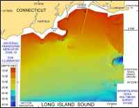 |
| Figure 9. Image shows the interpolated and regridded multibeam bathymetry from NOAA survey H11045 in north-central Long Island Sound off Bridgeport, Ct. Click on figure for larger image. |
|
|
