Data File Identifiers and Digital Data Files
A 3-digit mooring number is used to identify all files containing time-series data and is the key through which one can identify and (or) locate data records in the Woods Hole Science Center time series data management system. Individual data files are labeled by 4-digit numbers: the first three digits being the mooring number, and the last digit indicating the location of the instrument on the mooring. For example, 5541 identifies the topmost instrument on mooring 554, 5542 the next instrument down on mooring 554, etc. As data files are processed, additional identifiers are added to the four-digit identifier to indicate sensors, processing steps, and averaging.
Time series oceanographic observations:
The time series data from sites 1 to 8 are included on the second DVD-ROM in netCDF format. For both instrument deployments (see data available or mooring log for mooring numbers) data at the basic sampling interval are included as individual files.
The data format is the EPIC netCDF standard defined by the NOAA Pacific Marine Environmental Laboratory (PMEL). NetCDF is a very general, self-documenting, machine-transportable data format created and supported by UCAR ( http://www.unidata.ucar.edu/packages/netcdf/). EPIC ( http://www.pmel.noaa.gov/epic/) is a set of standards which allow researchers from different organizations to share oceanographic data without having to translate "foreign" data types into the local vernacular.
The naming convention for netCDF data files included on the second DVD-ROM is as follows:
7464Asc-a.nc
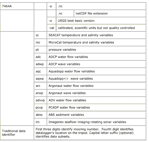
Description of variable names within files
Timeseries oceanographic observations (all sites, data by deployment)
Supporting observations
Supporting observations obtained from NOAA National Data Buoy Center (NDBC) moored buoy #41013 and C-MAN station FPSN7, from NOAA National Ocean Service (NOS) water level stations #8661070 and #8659897, from the COAMPS (Hodur, 1997) wind model, and from the United States Geological Survey (USGS) gauging stations along the Cape Fear River (#2105769) and Pee Dee River (#2131010).
The naming convention for netCDF data files is as follows:
41013h1-stdMet.nc
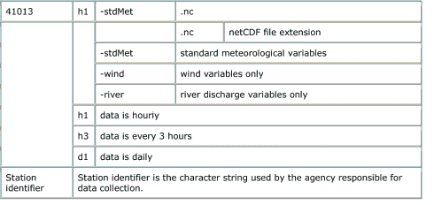
Description of variable names within files
Supporting observations October 1, 2003, to May 1, 2004.
 To view files in PDF format, download free copy of Adobe Reader. To view files in PDF format, download free copy of Adobe Reader.


|
