USGS Coastal and Marine Geology Program
|
|
Section 1 - Introduction
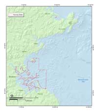
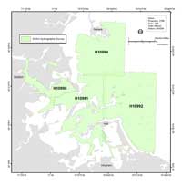
This report presents the surficial geologic framework data and information for the sea floor of Boston Harbor and Approaches, Massachusetts (fig. 1.1). This mapping was conducted as part of a cooperative program between the U.S. Geological Survey (USGS), the Massachusetts Office of Coastal Zone Management (CZM), and the National Oceanic and Atmospheric Administration (NOAA). The primary objective of this project was to provide sea floor geologic information and maps of Boston Harbor to aid resource management, scientific research, industry and the public. A secondary objective was to test the feasibility of using NOAA hydrographic survey data, normally collected to update navigation charts, to create maps of the sea floor suitable for geologic and habitat interpretations. Defining sea-floor geology is the first steps toward managing ocean resources and assessing environmental changes due to natural or human activity. The geophysical data for these maps were collected as part of hydrographic surveys carried out by NOAA in 2000 and 2001 (fig. 1.2). Bottom photographs, video, and samples of the sediments were collected in September 2004 to help in the interpretation of the geophysical data. Included in this report are high-resolution maps of the sea floor, at a scale of 1:25,000; the data used to create these maps in Geographic Information Systems (GIS) format; a GIS project; and a gallery of photographs of the sea floor. Companion maps of sea floor to the north Boston Harbor and Approaches are presented by Barnhardt and others (2006) and to the east by Butman and others (2003a,b,c). See Butman and others (2004) for a map of Massachusetts Bay at a scale of 1:125,000. The sections of this report are listed in the navigation bar along the left-hand margin of this page. Section 1 (this section) introduces the report. Section 2 presents the large-format map sheets. Section 3 describes data collection, processing, and analysis. Section 4 summarizes the geologic history of the region and discusses geomorphic and anthropogenic features within the study area. Section 4 also provides references that contain additional information about the region. Appendix 1 provides GIS layers of all the data collected in this study, Appendix 2 contains the grain size textural analyses of sediment samples, and Appendix 3 contains bottom photographs of the sea floor in JPG format.
|

 Back to List of Figures
 Forward to Next Section