USGS Coastal and Marine Geology Program
![]() Title | Geologic Setting | Introduction
| Methods | Bathymetric Overview |
Interpretation | Data Catalog
| Acknowledgments | References
| Figures
| Contacts
Title | Geologic Setting | Introduction
| Methods | Bathymetric Overview |
Interpretation | Data Catalog
| Acknowledgments | References
| Figures
| Contacts
 |
||
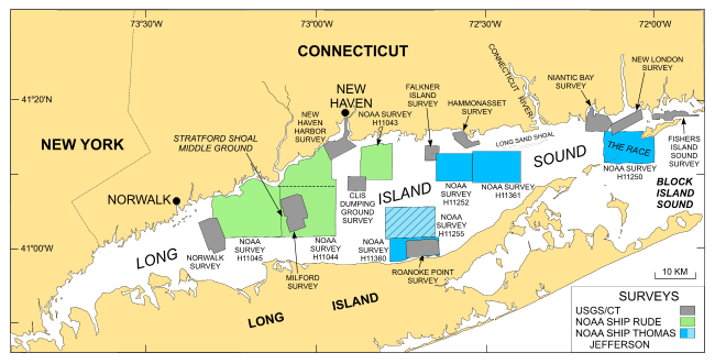
Figure 1. Map showing location of NOAA survey H11255 (light blue cross-hatched polygon). Other multibeam surveys by the NOAA ship Thomas Jefferson are shown in dark blue. Also shown are the sites of USGS sidescan sonar surveys in Long Island Sound: Norwalk--Twichell and others (1997); Milford--Twichell and others (1998); New Haven Harbor and New Haven Dumping Grounds--Poppe and others, 2001; Roanoke Point--Poppe and others (1999a); Falkner Island--Poppe and others (1999b); Hammonasset--Poppe and others (1997); Niantic Bay--Poppe and others (1998a); New London--Zajac and others (2000, 2003); Fishers Island Sound--Poppe and others (1998b). Sidescan sonar and bathymetric surveys H11043 (Poppe and others, 2004), H11044 (McMullen and others, 2005), and H11045 (Beaulieu and others, 2005) completed by the NOAA ship RUDE are shown in light green. | ||
