
Woods Hole Science Center
![]() Title |
Introduction |
Setting |
Methods |
Overview |
Interpretation |
Discussion |
Data Catalog |
Acknowledgments |
References |
Figures |
Bottom Photographs |
Sediment Data |
Contacts
Title |
Introduction |
Setting |
Methods |
Overview |
Interpretation |
Discussion |
Data Catalog |
Acknowledgments |
References |
Figures |
Bottom Photographs |
Sediment Data |
Contacts
 |
||
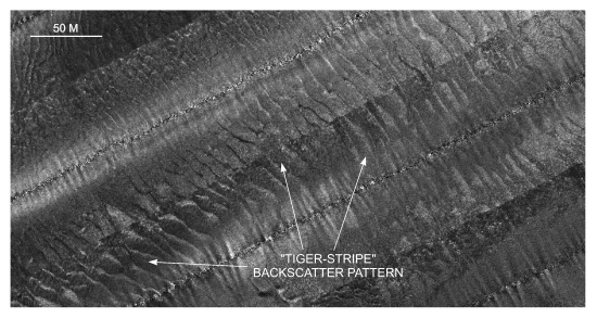
Figure 27. Detailed planar view of the sidescan sonar mosaic from north of Nashawena Island showing alternating bands of high and low backscatter ("tiger-stripe") pattern indicative of sand waves. Location of view is shown in figure 22. | ||


