
Woods Hole Science Center
![]() Title |
Introduction |
Setting |
Methods |
Overview |
Interpretation |
Discussion |
Data Catalog |
Acknowledgments |
References |
Figures |
Bottom Photographs |
Sediment Data |
Contacts
Title |
Introduction |
Setting |
Methods |
Overview |
Interpretation |
Discussion |
Data Catalog |
Acknowledgments |
References |
Figures |
Bottom Photographs |
Sediment Data |
Contacts
 |
||
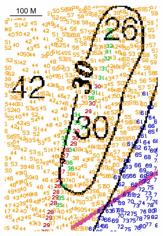
Figure 36. Detailed comparative view of the crest line from the largest sand wave south of Pasque Island. Note that the sand wave has migrated westward. Colored depths are from the 2004 survey; black depths and contours are from 1976; depths are in feet. Location of view is shown in figure 22. | ||


