Woods Hole Science Center
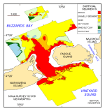
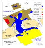
Distributions of surficial sediments and sedimentary environments were mapped within the study area. These distributions represent dominant long-term conditions and do not reflect small-scale variation or intermittent processes. All contacts between the textural distributions and sedimentary environments should be considered approximate because the transitions between the various environments are typically gradational, and lateral changes are seldom abrupt. Surficial SedimentsGravel, including boulders, occurs in the shallow waters along the coastlines of Pasque and Nashawena Islands, in the constricted Quicks Hole passage, and on isolated bathymetric highs north of Quicks and Robinsons Holes (fig. 28 and fig. 29). These coarse deposits are primarily associated with outcrops of glacial drift, and are probably lag deposits of the till that is exposed onshore in the Buzzards Bay moraine. Bottom video shows that small scattered patches of sand locally occur among the boulders. Aprons of gravelly sand, which commonly armor finer-grained underlying sediments, locally surround the gravel areas. Sand is the dominant sediment textural class in exposed deeper waters away from Quicks Hole (fig. 29). The sand across the southern part of the study area is typically medium to coarse grained and moderately to moderately well sorted. Conversely, sand north of the Hole is generally medium grained, poorly to very poorly sorted, and contains more mud. The silty sand, sand silt clay, and clayey silt lithologies form a textural progression of increasing mud content and decreasing benthic environmental energy. These lithologies occur in the more protected areas of the northern part of the study area. One small patch of sand silt clay occurs within Quick Hole and may represent an unwinnowed exposure of till. Sedimentary EnvironmentsFour distinct sedimentary environments are mapped within the study area and include areas of the sea floor characterized by erosion or nondeposition, coarse bedload transport, sorting or reworking, and deposition (fig. 30). Environments characterized by erosion or nondeposition, which reflect high-energy conditions (Knebel and Poppe, 2000), prevail in the relatively shallow waters around Pasque Island, Nashawena Island, on the elongate bathymetric high extending north from Quicks Hole, and on few isolated bathymetric highs across the northern part of the study area. Strong tidal currents and wind-driven waves prevent the deposition of Holocene marine sediments and erode the finer fraction from the sea-floor sediments, leaving exposed lag deposits of boulders and gravel. Seaweed, sponges, soft corals, and mussels obscure the rock surfaces. As water depth increases, the strength of storm and tidal currents at the sea floor decreases. Conditions favoring erosion or nondeposition are replaced by sedimentary environments characterized by coarse bedload transport. This environment, which is defined by sandwaves and megaripples, is prevalent across the southern part of the study area in Vineyard Sound and occurs in small patches north of Quicks Hole (fig. 30). The sediments are predominantly moderately sorted sand; ripples are ubiquitous on the sand-wave and megaripple surfaces. Moon snails, sand dollars, and skate are common in the bottom video. The sea floor across the northern part of the study area in Buzzards Bay and away from the openings to Quicks and Robinsons Holes is more protected from wind-driven currents. Sedimentary environments here are primarily characterized by processes associated with sediment sorting or reworking. Faint current ripples, observed on the surface of grab samples of sandy muds and muddy sands, and sediment resuspension, observed in bottom video, reflect these processes. Hermit crabs, starfish, welk, and shell debris are locally common in bottom video. The sea floor northwest of North Point on Nashawena Island and in small patches in the lee of nearby isolated bathymetric highs is characterized by low backscatter on the sidescan sonar mosaic and predominant long-term deposition (fig. 30). In these areas fine-grained sediments accumulate in the low-energy environments protected from strong tidal and storm conditions. Amphipod and polychaete tubes, shrimp burrows, and snail and rock crab tracks are locally common in these muddy sediments. |
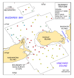
Click on figures for larger images.
|
![]() Title |
Introduction |
Setting |
Methods |
Overview |
Interpretation |
Discussion |
Data Catalog |
Acknowledgments |
References |
Figures |
Bottom Photographs |
Sediment Data |
Contacts
Title |
Introduction |
Setting |
Methods |
Overview |
Interpretation |
Discussion |
Data Catalog |
Acknowledgments |
References |
Figures |
Bottom Photographs |
Sediment Data |
Contacts