APALACHICOLABASEMAP - Base map for Apalachicola Florida

Metadata also available as - [Outline] - [Parseable text]

Frequently-anticipated questions:


What does this data set describe?

Title: APALACHICOLABASEMAP - Base map for Apalachicola Florida
Abstract:
These data were collected under a cooperative mapping program between the U.S. Geological Survey (USGS), the National Oceanic and Atmospheric Administration Coastal Services Center (NOAA\CSC), and the Apalachicola National Estuarine Research Reserve (NERR). The primary objectives of this program were to collect marine geophysical data to develop a suite of seafloor maps to better define the extent of oyster habitats, the overall seafloor geology of the bay and provide updated information for management of this resource. In addition to their value for management of the bay's oyster resources, the maps also provide a geologic framework for scientific research and the public.
High-resolution bathymetry, backscatter intensity, and seismic profile data were collected over 230 square kilometers of the floor of the bay. The study focused on the Apalachicola Bay and Western St. George Sound portions of the estuary in mostly in depths > 2.0 meters.
  1. How should this data set be cited?

    U.S. Geological Survey, 2007, APALACHICOLABASEMAP - Base map for Apalachicola Florida: Open-File Report 2006-1381, U.S. Geological Survey, Coastal and Marine Geology Program, Woods Hole Science Center, Woods Hole, Massachusetts.

    Online Links:

    This is part of the following larger work.

    Twichell, David C. , Andrews, Brian D. , Edmiston, H. Lee , and Stevenson, William R. , 2007, Geophysical Mapping of oyster habitats in a shallow estuary; Apalachicola Bay, Florida: Open-File Report 2006-1381, U.S. Geological Survey, Coastal and Marine Geology Program, Woods Hole Science Center, Woods Hole, Massachusetts.

    Online Links:

  2. What geographic area does the data set cover?

    West_Bounding_Coordinate: -85.385000
    East_Bounding_Coordinate: -84.572274
    North_Bounding_Coordinate: 29.867725
    South_Bounding_Coordinate: 29.586522

  3. What does it look like?

    <http://pubs.usgs.gov/of/2006/1381/GIS/thumbnails/apalachicolabasemap.jpg> (JPEG)
    JPEG image of basemap shapefile

  4. Does the data set describe conditions during a particular time period?

    Calendar_Date: 2007
    Currentness_Reference: publication date

  5. What is the general form of this data set?

    Geospatial_Data_Presentation_Form: vector digital data

  6. How does the data set represent geographic features?

    1. How are geographic features stored in the data set?

      This is a Vector data set. It contains the following vector data types (SDTS terminology):

      • G-polygon (34)

    2. What coordinate system is used to represent geographic features?

      Horizontal positions are specified in geographic coordinates, that is, latitude and longitude. Latitudes are given to the nearest 0.000000. Longitudes are given to the nearest 0.000000. Latitude and longitude values are specified in Decimal degrees.

      The horizontal datum used is D_WGS_1984.
      The ellipsoid used is WGS_1984.
      The semi-major axis of the ellipsoid used is 6378137.000000.
      The flattening of the ellipsoid used is 1/298.257224.

      Vertical_Coordinate_System_Definition:
      Altitude_System_Definition:

  7. How does the data set describe geographic features?

    ApalachicolaBaseMap
    Base map shapefile for cartography (Source: USGS)

    FID
    Internal feature number. (Source: ESRI)

    Sequential unique whole numbers that are automatically generated.

    Shape
    Feature geometry. (Source: ESRI)

    Coordinates defining the features.

    Type
    Type of base map data (Source: USGS)

    ValueDefinition
    Spoil AreasAreas from NOAA nautical chart delineating dredge spoil disposal area
    FairwayNavigation channel (dredged) for intracoastal waterway
    BridgeBridge structure from NOAA Nautical charts
    LandLand base map data from NOAA nautical chart

    Source
    Number of NOAA Chart (Source: NOAA)

    ValueDefinition
    NOAA Chart 11404NOAA Nautical Chart 11404 Intracoastal Waterway Carrabelle to Apalachicola Bay
    NOAA Chart 11402NOAA Nautical Chart 11402, Intracoastal Waterway, Apalachicola Bay to Lake Wimico

    Shape_Leng
    Length of feature in meters (Source: ESRI)

    Shape_Area
    Area of feature in meters squared. (Source: ESRI)

    Positive real numbers that are automatically generated.


Who produced the data set?

  1. Who are the originators of the data set? (may include formal authors, digital compilers, and editors)

  2. Who also contributed to the data set?

  3. To whom should users address questions about the data?

    Brian Andrews
    U.S. Geological Survey
    Geographer
    384 Woods Hole Rd
    Woods Hole, MA 02543-1598
    USA

    508-548-8700 x2348 (voice)
    508-457-2310 (FAX)
    bandrews@usgs.gov


Why was the data set created?

The purpose of this shapefile is to provide high resolution base map data for cartographic products published in U.S. Geological Survey (USGS) Open-File Report 2006-1381


How was the data set created?

  1. From what previous works were the data drawn?

    (source 1 of 1)
    National Oceanic and Atmospheric Administration (NOAA), NOAA Office of Coast Survey Electronic Navigational Charts (ENC).

    Online Links:

  2. How were the data generated, processed, and modified?

    Date: Jan-2007 (process 1 of 4)
    Downloaded NOAA Electronic Navigation Chart (ENC) files for NOAA Charts 11402 and 11404.

    Person who carried out this activity:

    Brian Andrews
    U.S. Geological Survey
    Geographer
    384 Woods Hole Rd.
    Woods Hole, MA 02543-1598
    USA

    508-548-8700 x2348 (voice)
    508-457-2310 (FAX)
    bandrews@usgs.gov

    Date: Jan-2007 (process 2 of 4)
    Converted the ENC files to a personal geodatabase using the ESRI S-57 converter.

    Person who carried out this activity:

    Brian Andrews
    U.S. Geological Survey
    Geographer
    384 Woods Hole Rd.
    Woods Hole, MA 02543-1598
    USA

    508-548-8700 x2348 (voice)
    508-457-2310 (FAX)
    bandrews@usgs.gov

    Date: Jan-2007 (process 3 of 4)
    Merged and dissolved all land features from the two charts to generate one polygon feature class representing all land features from the two charts. Also merged and dissolved all fairway features, dredge spoil features, and Bridge features to generate polygon feature classes representing each of these other three features

    Person who carried out this activity:

    Brian Andrews
    U.S. Geological Survey
    Geographer
    384 Woods Hole Rd.
    Woods Hole, MA 02543-1598
    USA

    508-548-8700 x2348 (voice)
    508-457-2310 (FAX)
    bandrews@usgs.gov

    Date: Jul-2007 (process 4 of 4)
    Exported feature class from personal geodatabase to a shapefile and projected to geographic.

    Person who carried out this activity:

    Brian Andrews
    U.S. Geological Survey
    Geographer
    384 Woods Hole Road
    Woods Hole, MA 02543-1598

    508-548-8700 x 2348 (voice)
    508-457-2310 (FAX)
    bandrews@usgs.gov

  3. What similar or related data should the user be aware of?


How reliable are the data; what problems remain in the data set?

  1. How well have the observations been checked?

  2. How accurate are the geographic locations?

  3. How accurate are the heights or depths?

  4. Where are the gaps in the data? What is missing?

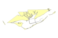
    These data represent all land above the mean lower low shoreline and locations of fairway, dredge spoil area and bridges as depicted on NOAA Charts 11404 and 11402 as distributed by NOAA.

  5. How consistent are the relationships among the observations, including topology?

    No additional checks for topological consistency were performed on these data


How can someone get a copy of the data set?

Are there legal restrictions on access or use of the data?

Access_Constraints: None
Use_Constraints:
Data are not intended for navigational use.
These data should not be used at resolutions for which they are not intended.
Public domain data from the U.S. Government are freely redistributable with proper metadata and source attribution. Please recognize the U.S. Geological Survey (USGS) as the source of this information.

  1. Who distributes the data set? (Distributor 1 of 1)

    Brian Andrews
    U.S. Geological Survey
    Geographer
    384 Woods Hole Rd.
    Woods Hole, MA 02543-1598
    USA

    508-548-8700 x2348 (voice)
    508-457-2310 (FAX)
    bandrews@usgs.gov

  2. What's the catalog number I need to order this data set?

    Downloadable Data

  3. What legal disclaimers am I supposed to read?

    Although this data set has been used by the U.S. Geological Survey (USGS), no warranty, expressed or implied, is made by the USGS as to the accuracy of the data and/or related materials. The act of distribution shall not constitute any such warranty, and no responsibility is assumed by the USGS in the use of these data or related materials.
    Any use of trade, product, or firm names is for descriptive purposes only and does not imply endorsement by the U.S. Government.

  4. How can I download or order the data?

  5. What hardware or software do I need in order to use the data set?

    The data are available in Environmental Systems Research Institute (ESRI) shapefile format. The user must have ArcGIS or ArcView 3.3 or greater software to read and process the data file. In lieu of ArcView or ArcGIS, the user may utilize another GIS application package capable of importing data. A free data viewer, ArcExplorer, capable of displaying the data is available from ESRI at www.esri.com.


Who wrote the metadata?

Dates:
Last modified: 27-Aug-2007
Metadata author:
U.S. Geological Survey
c/o Brian Andrews
Geographer
384 Woods Hole Rd.
Woods Hole, MA 02543-1598
USA

508-548-8700 x2348 (voice)
508-457-2310 (FAX)
bandrews@usgs.gov

Metadata standard:
FGDC Content Standards for Digital Geospatial Metadata (FGDC-STD-001-1998)
Metadata extensions used:


Generated by mp version 2.9.2 on Mon Aug 27 12:26:51 2007