B370_H11250_DTM2M.GUTM: GeoZui File of the 2-m Multibeam Bathymetric Data Collected During NOAA Survey H11250 in Eastern Long Island Sound (UTM, Zone 18)

Metadata also available as Outline | Text

Frequently-anticipated questions:


What does this data set describe?

Title:
B370_H11250_DTM2M.GUTM: GeoZui File of the 2-m Multibeam Bathymetric Data Collected During NOAA Survey H11250 in Eastern Long Island Sound (UTM, Zone 18)
Abstract:
Digital terrain models (DTMs) produced from multibeam bathymetric data provide valuable base maps for marine geological interpretations. These maps help define the geological variability of the seafloor (one of the primary controls of benthic habitat diversity); improve our understanding of the processes that control the distribution and transport of bottom sediments, and the distribution of benthic habitats and associated infaunal community structures; and provide a detailed framework for future research, monitoring, and management activities. The bathymetric survey interpreted herein (National Oceanic and Atmospheric Administration (NOAA) survey H11250) covers roughly 94 km2 of seafloor in easternmost Long Island Sound and westernmost Block Island Sound. This bathymetry has been examined in relation to seismic reflection data collected concurrently, as well as archived seismic profiles acquired as part of a long-standing geologic mapping partnership between the State of Connecticut and the U.S. Geological Survey (USGS). The objective of this work was to use these acoustic data sets to interpret geomorphological attributes of the seafloor, and to use these interpretations to better understand the Quaternary geologic history and modern sedimentary processes.
  1. How should this data set be cited?

    National Oceanic and Atmospheric Administration, 2007, B370_H11250_DTM2M.GUTM: GeoZui File of the 2-m Multibeam Bathymetric Data Collected During NOAA Survey H11250 in Eastern Long Island Sound (UTM, Zone 18): Open-File Report 2007-1012, U.S. Geological Survey, Coastal and Marine Geology Program, Woods Hole Science Center, Woods Hole, MA.

    Online Links:

    This is part of the following larger work.

    Poppe, L.J., DiGiacomo-Cohen, M.L., Doran, E.F., Smith, S.M., Stewart, H.F., and Forfinski, N.A., 2007, Geologic Interpretation and Multibeam Bathymetry of the Sea Floor in the Vicinity of the Race, Eastern Long Island Sound: Open-File Report 2007-1012, U.S. Geological Survey, Coastal and Marine Geology Program, Woods Hole Science Center, Woods Hole, MA.

    Online Links:

  2. What geographic area does the data set cover?

    West_Bounding_Coordinate: -72.154000
    East_Bounding_Coordinate: -71.992004
    North_Bounding_Coordinate: 41.270997
    South_Bounding_Coordinate: 41.188000

  3. What does it look like?

    <http://pubs.usgs.gov/of/2007/1012/data/bathy/grids/utm/geozui/b370_h11250_dtm2m.gif> (GIF)
    Thumbnail image showing the extent of soundings collected during NOAA survey H11250

  4. Does the data set describe conditions during a particular time period?

    Calendar_Date: 2003
    Currentness_Reference: ground condition

  5. What is the general form of this data set?

  6. How does the data set represent geographic features?

    1. How are geographic features stored in the data set?

    2. What coordinate system is used to represent geographic features?

      Grid_Coordinate_System_Name: Universal Transverse Mercator
      Universal_Transverse_Mercator:
      UTM_Zone_Number: 18
      Transverse_Mercator:
      Scale_Factor_at_Central_Meridian: 0.999600
      Longitude_of_Central_Meridian: -75.000000
      Latitude_of_Projection_Origin: 0.000000
      False_Easting: 500000.000000
      False_Northing: 0.000000

      Planar coordinates are encoded using row and column
      Planar coordinates are specified in meters

      The horizontal datum used is North American Datum of 1983.
      The ellipsoid used is Geodetic Reference System 80.
      The semi-major axis of the ellipsoid used is 6378137.000000.
      The flattening of the ellipsoid used is 1/298.257224.

      Vertical_Coordinate_System_Definition:
      Altitude_System_Definition:
      Depth_System_Definition:
      Depth_Datum_Name: Mean Lower Low Water
      Depth_Distance_Units: meters
      Depth_Encoding_Method: Explicit depth coordinate included with horizontal coordinates

  7. How does the data set describe geographic features?


Who produced the data set?

  1. Who are the originators of the data set? (may include formal authors, digital compilers, and editors)

  2. Who also contributed to the data set?

  3. To whom should users address questions about the data?

    U.S. Geological Survey
    c/o Lawrence Poppe
    Geologist
    384 Woods Hole Road
    Woods Hole, MA 02543-1598
    USA

    (508) 548-8700 x2314 (voice)
    (508) 457-2310 (FAX)
    lpoppe@usgs.gov


Why was the data set created?

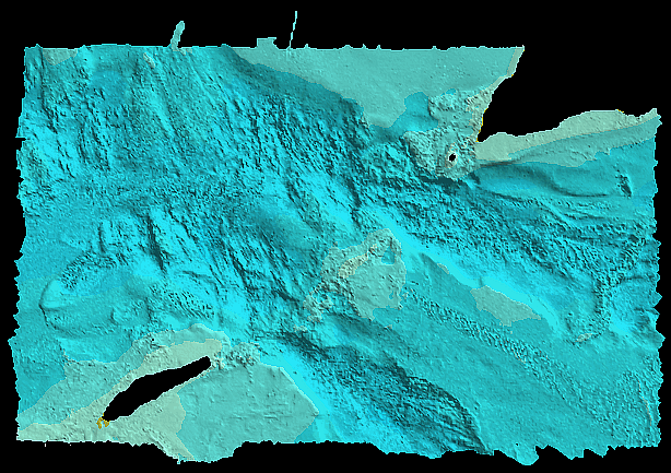
To release the GeoZui file containing the 2-m bathymetry generated from NOAA survey H11250 in Long Island Sound. A program (GeoZui3D) capable of reading this file can be downloaded free of charge via the World Wides Web (WWW) from Ocean Mapping, Marine GIS of the University of New Hampshire at: <http://www.seascallop.com/GeoZui.html>


How was the data set created?

  1. From what previous works were the data drawn?

    (source 1 of 1)
    .

    Type_of_Source_Media: DVD-ROM
    Source_Contribution:
    The original multibeam bathymetric data acquired with a Simrad EM 1002 echosounder and Reson 8101 and 8125 systems during NOAA survey H11250 aboard the NOAA ship Thomas Jefferson.

  2. How were the data generated, processed, and modified?

    Date: 2003 (process 1 of 1)
    The multibeam data for was acquired in XTF (extended Triton data format), recorded digitally through an ISIS data acquisition system, and processed using CARIS HIPS (Hydrographic Image Processing System) software for quality control, to incorporate sound velocity and tidal corrections, and to produce base surfaces averaging 2-m resolution over the study area. The data were exported in GeoZui format (.gutm) in UTM Zone 18.

    Person who carried out this activity:

    Shep Smith
    National Oceanic and Atmospheric Administration
    Field Operations Officer
    439 West York Street
    Norfolk, VA 23510
    USA

    (757) 441-6746 (voice)
    shep.smith@noaa.gov

    Data sources used in this process:
    • raw bathymetric data

    Data sources produced in this process:

    • b370_h11250_dtm2m.gutm

  3. What similar or related data should the user be aware of?

    Poppe, L.J., DiGiacomo-Cohen, M.L., Smith, S.M., Stewart, H.F., and Forfinski, N.A., 2006, Seafloor character and sedimentary processes in eastern Long Island Sound and Western Block Island Sound: Geo-Marine Letters v. 26, p. 59-68,.


How reliable are the data; what problems remain in the data set?

  1. How well have the observations been checked?

  2. How accurate are the geographic locations?

    Navigation was by differential GPS

  3. How accurate are the heights or depths?

  4. Where are the gaps in the data? What is missing?

    All collected data were processed and used to produce this dataset. The area is considered complete; gaps in the data lie in areas inaccessible to the survey vessels (shallow water surrounding islands).

  5. How consistent are the relationships among the observations, including topology?


How can someone get a copy of the data set?

Are there legal restrictions on access or use of the data?

Access_Constraints: None
Use_Constraints:
Data are not to be used for navigation purposes.

Public domain data are freely redistributable with proper metadata and source attribution. Please recognize the National Oceanic and Atmospheric Administration (NOAA) as the originator of this information.

  1. Who distributes the data set? (Distributor 1 of 1)

    U.S. Geological Survey
    c/o Larry Poppe
    Geologist
    384 Woods Hole Road
    Woods Hole, MA 02543-1598
    USA

    (508) 548-8700 x2314 (voice)
    (508) 457-2310 (FAX)
    lpoppe@usgs.gov

  2. What's the catalog number I need to order this data set?

    Downloadable Data

  3. What legal disclaimers am I supposed to read?

    Although this data set has been used by the U.S. Geological Survey (USGS), National Oceanic and Atmospheric Administration (NOAA) and Connecticut Department of Environmental Protection (CTDEP), no warranty, expressed or implied, is made by the USGS as to the accuracy of the data and/or related materials. The act of distribution shall not constitute any such warranty, and no responsibility is assumed by the USGS in the use of these data or related materials.

    Any use of trade, product, or firm names is for descriptive purposes only and does not imply endorsement by the U.S. Government.

  4. How can I download or order the data?

  5. What hardware or software do I need in order to use the data set?

    The user must have a program capable of reading and processing GeoZui files. This program (GeoZui3D) can be downloaded free of charge via the World Wides Web (WWW) from Ocean Mapping, Marine GIS of the University of New Hampshire at: <http://www.seascallop.com/GeoZui.html>


Who wrote the metadata?

Dates:
Last modified: 01-Jun-2007
Metadata author:
Larry Poppe
U.S. Geological Survey
Geologist
384 Woods Hole Road
Woods Hole, MA 02543-1598
USA

(508) 548-8700 x2314 (voice)
(508) 457-2310 (FAX)
lpoppe@usgs.gov

Metadata standard:
FGDC Content Standards for Digital Geospatial Metadata (FGDC-STD-001-1998)
Metadata extensions used:


Generated by mp version 2.8.6 on Fri Jun 01 11:33:28 2007