Poppe, L.J., and DiGiacomo-Cohen, M.L., 2007, H11250G_GEOL: Interpretive Data Layer Showing the Framework Geology of NOAA Survey H11250 (Geographic): Open-File Report 2007-1012, U.S. Geological Survey, Coastal and Marine Geology Program, Woods Hole Science Center, Woods Hole, MA.This is part of the following larger work.Online Links:
- <http://pubs.usgs.gov/of/2007/1012/data/interpretation/geologic/h11250g_geol.zip>
- <http://pubs.usgs.gov/of/2007/1012/data/interpretation/geologic/>
- <http://pubs.usgs.gov/of/2007/1012/html/catalog.html>
Poppe, L.J., DiGiacomo-Cohen, M.L., Doran, E.F., Smith, S.M., Stewart, H.F., and Forfinski, N.A., 2007, Geologic Interpretation and Multibeam Bathymetry of the Sea Floor in the Vicinity of the Race, Eastern Long Island Sound: Open-File Report 2007-1012, U.S. Geological Survey, Coastal and Marine Geology Program, Woods Hole Science Center, Woods Hole, MA.Online Links:
This is a Vector data set. It contains the following vector data types (SDTS terminology):
Horizontal positions are specified in geographic coordinates, that is, latitude and longitude. Latitudes are given to the nearest 0.000001. Longitudes are given to the nearest 0.000001. Latitude and longitude values are specified in Decimal degrees.
The horizontal datum used is D_WGS_1984.
The ellipsoid used is WGS_1984.
The semi-major axis of the ellipsoid used is 6378137.000000.
The flattening of the ellipsoid used is 1/298.257224.
Sequential unique whole numbers that are automatically generated.
Coordinates defining the features.
Positive real numbers that are automatically generated.
Positive real numbers that are automatically generated.
| Value | Definition |
|---|---|
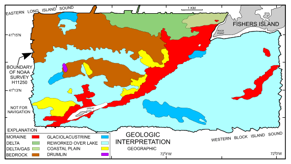
| delta | glacial lake deltaic deposits |
| delta/gas | gas-charged marine deposits of Holocene age |
| lake | glacial lake-bottom deposits |
| moraine | moraine deposits |
| reworked over lake | reworked marine deposits (includes bedforms and lag deposits) over glacial lake-bottom deposits |
| bedrock | Paleozoic bedrock |
| drumlin | glacial drumlin |
| coastal plain | semi-consolidated Cretaceous coastal plain deposits |
| no data | gaps in the original data |
| Value | Definition |
|---|---|
| D | delta |
| M | moraine |
| R/L | reworked over lake |
| K/m | coastal plain |
| L | lake |
| Pz | bedrock |
| M/F | moraine/fan? |
| K/d | drumlin |
| TR | thick reworked over lake |
| HG | Holocene/gas |
| 0 | no data |
Source data were acquired during National Oceanic and Atmospheric Administration (NOAA) survey H11250. Please acknowledge NOAA as the originator of the dataset from which this dataset was derived.
508-548-8700 x2314 (voice)
508-457-2310 (FAX)
lpoppe@usgs
To release interpretations the geologic features based on data collected during NOAA survey H11250 in easternmost Long Island Sound and westernmost Block Island Sound, in geographic. This GIS layer serves a starting point for a geologic study of the area in that it shows the geologic units that subcrop and influence the bathymetry and geometry of the Race, Long Island Sound. The detailed bathymetic data and their interpretations serve many purposes, including: (1) defining the geological variability of the sea floor, which is one of the primary controls of benthic habitat diversity; (2) improving our understanding of the processes that control the distribution and transport of bottom sediments and the distribution of benthic habitats and associated infaunal community structures; and (3) providing a detailed framework for future research, monitoring, and management activities. The bathymetric data models also serve as base maps for subsequent sedimentological, geochemical, and biological observations, because precise information on environmental setting is important for selection of sampling sites and for accurate interpretation of point measurements.
U.S. Geological Survey, National Oceanic and Atmospheric Administration, and Connecticut Department of Environmental Protection, 2004, h11250g: Long Island Sound Resource Center.
Person who carried out this activity:
(860) 405-9210 (voice)
mdicohen@usgs.gov
Data sources produced in this process:
Person who carried out this activity:
860-405-9210 (voice)
mdicohenusgs.gov
Data sources produced in this process:
Poppe, L.J., DiGiacomo-Cohen, M.L., Smith, S.M., Stewart, H.F., and Forfinski, N.A., 2006, Seafloor character and sedimentary processes in eastern Long Island Sound and Western Block Island Sound: Geo-Marine Letters v. 26, p. 59-68.
The attribute values represent interpreted features; accuracy has been checked by the compilers.
Navigation was by differential GPS; positional accuracy to less than 10 m. Interpreted polygons are accurately located given the nature and scale of the features. Previously collected seismic data used to aid the interpretation of the multibeam data was collected by ship navigated by Loran C which is less positional accuracy than GPS.
The interpretation is considered complete for the data/area provided. There are gaps in the bathymetric source data in areas inaccessible to the survey vessels (shallow water surrounding islands).
The interpretation is topologically consistent. There are gaps in the bathymetric source data in areas inaccessible to the survey vessels (shallow water surrounding islands).
Are there legal restrictions on access or use of the data?
- Access_Constraints: None
- Use_Constraints:
- Public domain data are freely redistributable with proper metadata and source attribution. Please recognize the U.S. Geological Survey (USGS) and the Connecticut Department of Environmental Protection (CTDEP) as the originators of this dataset.
508-548-8700 x2314 (voice)
508-457-2310 (FAX)
lpoppe@usgs.gov
Downloadable Data - H11250G_GEO - ArcGIS shapefile
Although this data set has been used by the U.S. Geological Survey (USGS), Connecticut Department of Environmental Protection (CTDEP) and the National Oceanic and Atmospheric Administration (NOAA), no warranty, expressed or implied, is made by the USGS, CTDEP or NOAA as to the accuracy of the data and/or related materials. The act of distribution shall not constitute any such warranty, and no responsibility is assumed by the USGS, CTDEP or NOAA in the use of these data or related materials.Any use of trade, product, or firm names is for descriptive purposes only and does not imply endorsement by the U.S. Government.
| Data format: | One file (h11250g_geol.zip) containg the shapefile, browse graphic, and metadata in format SHP ESRI Shapefile Size: 0.074 |
|---|---|
| Network links: |
<http://pubs.usgs.gov/of/2007/1012/data/interpretation/geologic/h11250g_geol.zip> <http://pubs.usgs.gov/of/2007/1012/data/interpretation/geologic/> <http://pubs.usgs.gov/of/2007/1012/html/catalog.html> |
| Media you can order: | DVD-ROM (Density 4.75 Gbytes) (format UDF) |
These data are available in Environmental Systems Research Institute (ESRI) shapefile format. The user must have ArcGIS or ArcView 3.0 or greater software to read and process the data file. In lieu of ArcView or ArcGIS, the user may utilize another GIS application package capable of importing data. A free data viewer, ArcExplorer, capable of displaying the data is available from ESRI at www.esri.com.
508-548-8700 x2314 (voice)
lpoppe@usgs.gov