
Barchanoid Sand Waves
Barchanoid sand waves are most common away from the shoals on the Great Round Shoal Channel floor where the Holocene sediments are thinner (fig. 23). These waves commonly align into elongate fields, having smaller isolated waves concentrated at the western ends of the fields (figs. 28 and 29). Individual barchanoid sand waves average less than 100 m wide, but can exceed 250 m. Eastward within barchanoid wave fields wavelengths increase, the fields widen, and the barchanoid waves become larger and coalesce into complex forms and highly-curved ridges. In places, barchanoid waves grade laterally into transverse morphologies (fig. 23). The slip faces of both small individual and large complex barchanoid sand waves are at or near the angle of repose (30-32°), but the stoss slopes are slightly shallower for the smaller sand waves. The sea floor east of the barchanoid wave troughs is relatively smooth, but the stoss slopes are typically covered in megaripples (fig. 30). Although the complex forms retain their arcuate slip faces, the horns are shortened and crestlines commonly bifurcate.
Relief of the barchanoid waves is typically 2-4 m. However, linear scour depressions, which cut into the underlying deposits and are probably formed by roll vortexes, commonly occur in the troughs within the convex areas of the larger barchanoid waves. If trough-to-crest amplitudes are measured from these depressions the waves appear much larger, and barchanoid waves have average amplitudes of 5-7 m, and a couple of the giant waves exceed 13 m (fig. 31). The presence of "blow-out" depressions is evidence for intense scour that occurs on the down-current sides of the barchanoid sand waves.
Regardless of size, location, and complexity, all of the barchanoid sand waves are concave eastward indicating net eastward sediment transport (McKee, 1966; Cacchione and others, 1987). Asymmetry of megaripples on the stoss slopes of the barchanoid sand waves, of adjacent straight-crested sand waves, and of scour marks around nearby boulders also indicates net eastward transport.
Transverse Sand Waves
The transverse bedforms, which exhibit an almost continuous spectrum of amplitudes and crestline lengths, dominate the west-central part of the study area and along the edges of Great Round Shoal Channel adjacent to Great Round Shoal and Point Rip. Current ripples occur on the flanks of the megaripples, megaripples occur on the flanks of sand waves, and sand waves occur on the flanks of larger sand waves (fig. 27).
Asymmetry of the transverse sand waves, which can be used to indicate direction of net sediment transport (Ludwick, 1972; Allen, 1968; Allen, 1980), is typically pronounced with slip faces that are oriented generally toward the east (figs. 31, 32 and 33). This asymmetry suggests a flow-transverse crest orientation and net eastward sediment transport. Wave-crest morphology is variable and sand-wave fields with relatively straight, smoothly sinuous, undulating, and bifurcating crest forms occur. Borders of sand-wave fields can be rather abrupt. Bifurcation of the wave crests, where present, is most common near abrupt edges of the fields (fig. 23). The occurrence of this crest morphology at these locations should be expected because bifurcation of wave crests indicates transitional flow conditions and the development of secondary flows (Aliotta and Perillo, 1987). The crest of a sand wave may bifurcate if the forces of tidal oscillation do not remain equal along its entire length, especially if the contact between flow cells is relatively sharp or if differences in flow rate or direction are relatively great.
Exceptions to the general asymmetry described above occur in the middle of the Channel just west of the tip of Great Round Shoal and along the south-central edge of the study area east of the tip of Point Rip. In the first case, the transverse sand waves display a symmetrical form and crest lines that roughly parallel the axis of the Channel (fig. 34). In the later case, the slip faces are oriented to the west and suggest that counter currents in this area maintain and limit the eastward growth of Point Rip shoal (fig. 35).
Scour Features
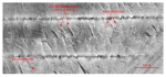
The intensity of tidal-current scour is evidenced by depressions around obstructions that are visible in the backscatter and bathymetry. Swirling currents develop around boulders that protrude through surficial sediments. Turbulence causes increased flow velocity sufficient to scour the sea floor downstream from obstructions and to produce high-backscatter (i.e., coarse-sediment) floored sharp-pointed depressions called obstacle marks. Good examples of these bedforms, also known as comet marks, are present around boulders in the eastern part of the study area (fig. 25). Obstacle-mark asymmetry around these boulders indicates net sediment transport is toward the east and, together with its current-swept appearance (fig. 26), is evidence for erosional environments interpreted for this part of the Channel.
The strong oscillatory nature of the tidal currents is also illustrated by the two large scour depressions that flank the southeastern tip of Great Round Shoal (fig. 24). The larger of the depressions lies to the east of the shoals tip, ranges from about 300 - 500 m wide, and is as much as 27 m deeper than the adjacent sea floor. While tidal flow in the middle of the Channel commonly exceeds 80 cm/s (Eldridge Tide and Pilot Book, 2006), constriction of the gross tidal flow leads to increased current speeds off promontories, such as the tip of Great Round Shoal, and formation of characteristic eddy patterns of great competence (Pingree, 1978). As the swirling turbulent water in these fast eddies suspends and rolls gravelly sediment around in the depressions, impacts cause abrasion and the tearing of clasts from the walls and floor. In this manner continued erosion has created and enlarged these depressions. Similar features, albeit on a much smaller scale, are the cylindrical cavities or potholes found cut in stream beds.
|
Click on figures for larger images.
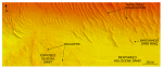 | Figure 23. Detailed planar view of exposed glacial drift and the sand waves at the transition from shoal to channel from the DTM produced during NOAA survey H11079. Note that crest-line bifurcations are most common along the edge of a sand-wave field and that boulders are present on the exposed surface of the glacial drift. Location of view is shown in figure 22; depth key is shown in figure 20.
|
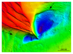 | Figure 24. Detailed planar view of scour depressions flanking the southeastern tip of Great Round Shoal from the DTM produced during NOAA survey H11079. Note that the scour depression northeast of the tip is deeper and larger. Location of view is shown in figure 22; depth key is shown in figure 20.
|
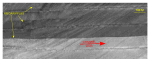
 | Figure 25. Detailed planar view of a comet structure associated with a boulder from the sidescan-sonar mosaic produced during NOAA survey H11079. Higher backscatter within this feature shows that coarser grained sediment is present there; scour asymmetry indicates that net transport is to the northeast. Location of view is shown in figure 22.
|
 | Figure 26. Detailed planar view of the sidescan-sonar mosaic produced during NOAA survey H11079 showing the current-swept appearance that characterizes much of the eastern part of the study area. Note the isolated patches of megaripples. Location of view is shown in figure 22.
|
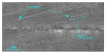
 | Figure 27. Detailed planar view of the sidescan-sonar mosaic produced during NOAA survey H11079 showing relatively straight to sinuous alternating bands of high and low backscatter ("tiger-stripe") pattern indicative of transverse sand waves. Note presence of megaripples on the stoss slopes indicative of active transport. Location of view is shown in figure 22.
|
 |
Figure 28. Detailed planar view of the barchanoid sand waves near the western end of Great Round Shoal Channel from the DTM produced during NOAA survey H11079. Note that wave orientation indicates net eastward transport, and that the waves become more complex downcurrent. Location of view is shown in figure 22; depth key is shown in figure 20.
|
 |
Figure 29. Detailed planar view of the barchanoid sand waves near the northeastern end of Great Round Shoal Channel from the DTM produced during NOAA survey H11079. Note that wave orientation indicates net eastward transport. Location of view is shown in figure 22; depth key is shown in figure 20.
|
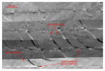 |
Figure 30. Detailed planar view of the sidescan-sonar mosaic produced during NOAA survey H11079 showing curved alternating bands of high and low backscatter ("tiger-stripe") pattern indicative of individual and complex barchanoid sand waves. Note presence of megaripples on the stoss slopes indicative of active transport. Location of view is shown in figure 22.
|
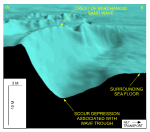 |
Figure 31. Detailed perspective view looking north of the barchanoid sand waves near the western end of Great Round Shoal Channel from the DTM produced during NOAA survey H11079. Note that orientation indicates net eastward transport, and that the troughs are scoured below the surrounding sea floor. Scale bars are only valid in the foreground; location of view is shown in figure 22.
|
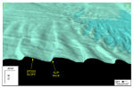 |
Figure 32. Detailed perspective view looking south of the transverse sand waves along the southern edge of Great Round Shoal from the DTM produced during NOAA survey H11079. Note that wave asymmetry and slip face orientation indicate net eastward transport. Scale bars are only valid in the foreground; location of view is shown in figure 22.
|
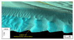 |
Figure 33. Detailed perspective view looking north of the transverse sand waves adjacent to the southeastern tip of Great Round Shoal from the DTM produced during NOAA survey H11079. Note that wave asymmetry and slip face orientation indicate net eastward transport. Scale bars are only valid in the foreground; location of view is shown in figure 22.
|
 |
Figure 34. Detailed planar view of the symmetrical sand waves in the central part of Great Round Shoal Channel from the DTM produced during NOAA survey H11079. Wave crests within this field parallel the axis of channel. Location of view is shown in figure 22; depth key is shown in figure 20.
|
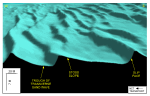 |
Figure 35. Detailed perspective view looking north of the transverse sand waves near the south-central part of Great Round Shoal Channel from the DTM produced during NOAA survey H11079. Note that wave asymmetry and slip face orientation indicate net westward transport. Scale bars are only valid in the foreground; location of view is shown in figure 22.
|
|


