Woods Hole Science Center
Sidescan-Sonar Imagery, Multibeam Bathymetry, and Surficial Geologic Interpretations of the Sea Floor in Rhode Island Sound, off Sakonnet Point, Rhode Island
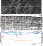
Erosional outliers and small hills and scarps are distinct features in the study area that have not been previously mapped. They are interpreted to have formed from the deposition of glacial lake sediments and from the erosion of paleoshorelines as sea level transgressed northward. Glaciolacustrine sediments are thought to have been deposited in the study area during recession of the Laurentide ice sheet. Some theories for the origin of glaciolacustrine sediment in RIS include transport and deposition of the sediment by meltwater streams (O'Hara and Oldale, 1980) or by the catastrophic drainage of glacial lakes (Uchupi and others, 2001). However, in this area, the presence of up to 15 m of stratified drift associated with erosional outliers of cohesive sediments indicates that these are glaciolacustrine sediments deposited in situ. Stratified glaciolacustrine sediments are located in what was likely the ice-distal side of the lake where water energy was low and fine-grained sediment could settle. Stratification of the lake sediments tends to fade to the northwest (fig. 15), suggesting higher energy and ice-proximal paleoenvironments lay in that direction. Erosion of the till and glaciolacustrine sediment probably occurred during lake drainage and subaerial exposure prior to marine incursion. After glacial recession, when sea level was at a lower stand than at present, much of what is now Rhode Island Sound was subaerially exposed. As sea level rose, shorelines moved northward across the area, depositing and eroding features in the sea floor. The hills and small scarps in our study area are probably erosional features formed as wave-cut terraces in paleoshorelines that have been preserved because of the sediment's high cohesiveness. The paleoshoreline features at 24-27 m probably formed 8.4-8.7 ka and the features at 30-35 m probably formed between 9.0-9.8 ka based on a sea-level-rise curve for southeastern Massachusetts (Oldale and O'Hara, 1980). Depositional paleoshoreline features have been found in other areas near RIS. Profiles of a paleoshoreline located about 24 m below present sea level near Block Island, thought to be from 8.3-9 ka, consist of barrier spit, lagoon, and headland features as well as terraces (McMaster and Garrison, 1967). These features are similar to, although larger than the profiles of the hills and scarps in RIS. A drowned spit off Cape Ann, MA with seaward-dipping reflectors marks a sea level 50 m below present (Oldale, 1985). Though the hills in our study area are similar in profile to the spits, they are not distinct seismic units with dipping reflectors and they are only about 0.5 m in height on the upslope side. If there were spits or other depositional features associated with the paleoshorelines in RIS, then they would probably not have been preserved owing to their small size. Other previously described paleoshorelines in the region are composed of erosional and depositional features. Paleoshorelines in Long Island Sound, lying under about 15 m of estuarine deposits, show planar, terraced surfaces with lens-shaped seismic units and erosional steps or scarps (Gayes and Bokuniewicz, 1991). The paleoshorelines in Long Island Sound mark shorelines at depths including 25-27 m, thought to have formed 8.5-9 ka, 30 m, and 37-38 m, thought to have formed 10-10.5 ka (Gayes and Bokuniewicz, 1991). South of our study area, on the continental shelf, Garrison and McMaster (1966) found wave cut terraces with scarps and a ridge and depression topography interpreted to be barrier beaches and lagoons that occur at depths including 24 m. Because of their similar depth, we believe that the terraces near Block Island described by McMaster and Garrison (1967) and those on the continental shelf described by Garrison and McMaster (1966) are coeval with the paleoshoreline features at 24-27 m within the study area. |