Woods Hole Science Center
Sidescan-Sonar Imagery, Multibeam Bathymetry, and Surficial Geologic Interpretations of the Sea Floor in Rhode Island Sound, off Sakonnet Point, Rhode Island
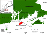
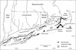
Rhode Island Sound (RIS) is located offshore of Rhode Island and southeastern Massachusetts between Block Island and Martha's Vineyard (fig. 1). It covers an area of over 2500 km² to the east of Block Island Sound and reaches depths of about 60 m. The stratigraphy underlying RIS is composed of a Proterozoic to Paleozoic basement of gneiss and schist with pegmatite and granitic intrusives, overlain by Upper Cretaceous coastal plain and continental shelf sediments in the south and Wisconsin glacial deposits throughout the region, topped by Holocene estuarine and marine sediments (fig. 3; McMaster and others, 1968; O'Hara and Oldale, 1980). A cuesta formed from the northern terminus of the Upper Cretaceous sediments crosses the southern part of the study area (O'Hara and Oldale, 1980). The uppermost Wisconsin glacial deposits and Holocene sediments are further subdivided based on our interpretations of seismic-reflection data and those of O'Hara and Oldale (1980). The surficial geology in the study area consists of glacial drift, including moraine, outwash and glaciolacustrine deposits, and fluvial and estuarine sediments. Two end moraines cross RIS and are evident as bands of gravelly sediment and submarine ridges (fig. 4; McMaster, 1960). The Ronkonkoma-Nantucket Moraine represents the maximum extent of the Laurentide ice sheet at around 20 ka (Uchupi and others, 2001). The Harbor Hill-Roanoke Point-Charlestown-Buzzards Bay Moraine represents the retreated ice sheet position at about 18 ka (Uchupi and others, 2001). The southwestern segment of the Buzzards Bay Moraine, which crosses the southern part of our study area, is thought to be composed of proglacial deltaic and lacustrine sediments capped by a thin subglacial till, similar to the Buzzards Bay Moraine (Oldale and O'Hara, 1978; O'Hara and Oldale, 1980). Offshore, the moraines in RIS are capped by a lag deposit of sand, gravel, and boulders resulting from winnowing of the till by marine processes (O'Hara and Oldale, 1980). The northern part of the study area has patches of exposed glacial drift and outwash plain deposits of sands and gravels as well as glaciolacustrine silts and clays, thought to be deposited by meltwater streams from the Buzzards Bay ice lobe (O'Hara and Oldale, 1980) or from the drainage of Lake Cape Cod Bay (Uchupi and others, 2001). Much of our study area was mapped by O'Hara and Oldale (1980) as having a surface consisting of Holocene fluvial and estuarine deposits of sands, gravels, and muds up to 16 m thick. The fluvial sediments were deposited during subaerial exposure of the shelf after glacial retreat and during the drainage of glacial lakes, while estuarine sediments were deposited during the northward transgression of the shoreline across the sound. |