
Woods Hole Science Center
![]() Title |
Introduction |
Setting |
Methods |
Results |
Discussion |
Data Catalog |
Acknowledgments |
References |
Figures |
Contacts
Title |
Introduction |
Setting |
Methods |
Results |
Discussion |
Data Catalog |
Acknowledgments |
References |
Figures |
Contacts
 |
||
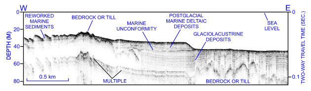
Figure 19. CHIRP high-resolution seismic-reflection profile from the eastern part of survey H11361 showing exposed till and (or) bedrock surface northeast of Six Mile Reef. Note layered seismic character of the glaciolacustrine deposits and sand wave asymmetry suggesting westward transport. Location of seismic profile is shown in figure 15. | ||


