Woods Hole Science Center
|
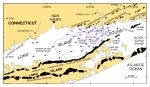
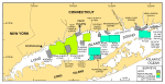
Digital terrain models, which can be produced from multibeam bathymetric data, are ordered arrays of depths for a number of sea-floor positions sampled at regularly spaced intervals. These models provide valuable base maps for marine geological interpretations that help define the variability of the sea floor (one of the primary controls of benthic habitat diversity), improve our understanding of the processes that control the distribution and transport of bottom sediments and the distribution of benthic habitats, and provide a detailed framework to guide and assist future research, monitoring, and management activities. The bathymetry interpreted herein was processed from data collected by National Oceanic and Atmospheric Administration vessels during hydrographic surveys H11361 and H11252. These surveys mapped roughly 156 km² of sea floor in the vicinity of Six Mile Reef, an area of eastern Long Island Sound where the sea floor is characterized by fields of large sand waves and an east-west decreasing gradient of bottom tidal-current speeds (fig. 1). Interpretations of the bathymetry are supplemented by concurrently collected seismic reflection data, as well as archived historic seismic profiles, sediment samples and bottom photography collected as part of a long-standing geologic mapping partnership between the State of Connecticut and the U.S. Geological Survey (fig. 2). The purpose of this digital report is 1) to provide the acoustic data layers produced during the above mentioned surveys, 2) to use them to describe the sea-floor character and bedform morphologies near Six Mile Reef, and 3) to relate these descriptions to ongoing processes and sedimentary environments. |
Click on figures for larger images.
|
![]() Title |
Introduction |
Setting |
Methods |
Results |
Discussion |
Data Catalog |
Acknowledgments |
References |
Figures |
Contacts |
Disclaimers
Title |
Introduction |
Setting |
Methods |
Results |
Discussion |
Data Catalog |
Acknowledgments |
References |
Figures |
Contacts |
Disclaimers