USGS Coastal and Marine Geology Program
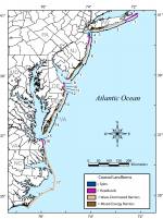
Seventeen coastal compartments were identified in the SAP mid-Atlantic focus area (fig. 1). The compartments were classified as one of the four geomorphic types described above. The potential coastal responses to the sea-level rise scenarios are described below and the potential responses to the first three sea-level rise scenarios are shown in figure 3. Three caveats to this approach were identified for this assessment. These are:
To express the likelihood of a given outcome for a particular sea-level rise scenario, terminology modified from CCSP (2006) is used to quantify and communicate the degree of likelihood of a given outcome identified by this sea-level rise impact assessment (fig. 4). This represents the degree of confidence that the committee members believe that a specific outcome will be realized. These terms should not be construed to represent a quantitative relationship between a specific sea-level rise scenario and a specific dimension of coastal change, or rate at which a specific process operates on a coastal geomorphic compartment.
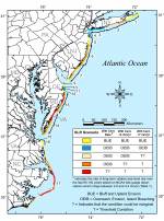
Spits (Compartments 4, 9, 15)For the first three sea-level rise scenarios (the 20th century rate, the 20th century rate + 2 mm/yr, and the 20th century rate + 7 mm/yr) it is virtually certain that the coastal spits in the mid-Atlantic Bight will be subject to increased storm overwash, erosion, deposition over the next century. It is virtually certain that some of these coastal spits will continue to prograde though the accretion of sediments from longshore transport as erosion of updrift coastal compartments occurs. For a 2 m rise in sea level, it is likely that threshold behavior could occur for this type of coastal landform (rapid landward and/or alongshore migration). Headlands (Compartments 1, 5, 8, 10, 12, 16)Over the next century, it is virtually certain that these headlands will be subject to increased erosion for all four sea-level rise scenarios. It is very likely that shoreline and upland (bluff) erosion will accelerate in response to projected increases in sea-level. Wave-Dominated Barrier Islands (Compartments 2, 6, 11, 13, 17)Potential sea-level rise impacts on wave-dominated barriers in the mid-Atlantic Bight vary spatially and depend on the sea-level rise scenario (fig. 3). Assuming that the 20th century rate rates of sea-level rise will continue, it is virtually certain that the majority of the wave-dominated barrier islands in the mid-Atlantic Bight will continue to experience morphological changes through erosion, overwash, and inlet formation as they have over the last several centuries. The northern portion of Assateague Island (compartment 13) is an exception. Here the shoreline exhibits high rates of erosion and large portions of this barrier are submerged during moderate storms. At times in the past, large storms have breached and segmented portions of northern Assateague Island (Morton and others, 2003). Due to this behavior, it is possible that these portions of the coast are already at a geomorphic threshold. With any increase in sea level, it is virtually certain that this barrier island will exhibit large changes in morphology ultimately leading to the degradation of this island. Periodic nourishment and sand bypassing at Ocean City Inlet may reduce erosion on compartment 13, but the long-term sustainability of this practice is uncertain. Small segments within the highly developed portion of the North Carolina Outer Banks (fig. 3) may similarly be nearing a geomorphic threshold (Riggs and Ames, 2003).
For the second sea-level rise scenario, the 20th century rate + 2 mm/yr, it is virtually certain that the majority of the wave-dominated barrier islands in the mid-Atlantic Bight will continue to experience morphological changes through overwash, erosion, and inlet formation as they have over the last several centuries. It is also about as likely as not that a geomorphic threshold could be reached, resulting in rapid morphological changes in these barrier systems. It is very likely that the barrier islands along the shores of northern Assateague Island (compartment 13) and a substantial portion within the center of compartment 17 (Riggs and Ames, 2003) could exhibit threshold behavior (barrier migration, segmentation, or disintegration). For the second sea-level rise scenario, the ability of wetlands to maintain their elevation through accretion at higher rates of sea-level rise may be reduced (Reed and others, 2007). It is about as likely as not that the loss of back-barrier marshes and shallow submarine shoals could lead to changes in hydrodynamic conditions between tidal inlets and back-barrier lagoons affecting the evolution of barrier islands (e.g., FitzGerald and others, 2003 and 2006). For the third sea-level rise scenario, the 20th century rate + 7 mm/yr, it is very likely that the potential for threshold behavior will increase. It is virtually certain that a 2 m sea-level rise will lead to threshold behavior for this landform type. Mixed-Energy Barrier Islands (Compartments 3, 7, 14)The response of mixed-energy, tide-dominated, barrier islands will vary among coastal compartments. For the first two sea-level rise scenarios (the 20th century rate and the 20th century rate + 2mm/yr), the mixed-energy, tide-dominated, barrier islands along the mid-Atlantic Bight will be subject to processes much as have occurred over the last century. Storm overwash and shoreline erosion are very likely to occur over the next century. Given the degree to which these barriers have been developed, it is difficult to determine the likelihood of future inlet breaches, or whether such breaches would be allowed to persist. In addition, changes to the back-barrier shores are uncertain due to the extent of development. For the higher sea-level rise scenarios (the 20th century rate + 7 mm/yr or greater), it is about as likely as not that these barriers could reach a geomorphic threshold. This threshold is dependent on the availability of sand from the longshore transport system to supply the barrier. It is virtually certain that a 2 m sea-level rise will have severe consequences along the shores of this compartment, including one or more of the extreme responses described above. The ability of wetlands to maintain their elevation through accretion at higher rates of sea-level rise may be reduced (Reed and others, 2007). It is about as likely as not that the loss of back-barrier marshes and shallow submarine shoals could lead to changes in the hydrodynamic conditions between tidal inlets and back-barrier lagoons, affecting the evolution of barrier islands (FitzGerald and others, 2003 and 2006). It is about as likely as not that four of the barrier islands along the Virginia coast (Wallops Island, Assawoman Island, Metompkin Island, and Cedar Island) are presently at a geomorphic threshold. Thus, it is very likely that further sea-level rise will contribute to significant changes resulting in the landward migration, disintegration, or segmentation of these barrier islands. |