
Woods Hole Science Center
Sidescan-Sonar Imagery and Surficial Geologic Interpretations of the Sea Floor in Central Rhode Island Sound
![]() Title |
Introduction |
Geologic Setting |
Data Acquisition/Processing |
Bathymetry |
Seismic Reflection Data |
Sidescan Sonar Imagery |
Environments |
Discussion |
Summary |
GIS Data Catalog |
Acknowledgments |
References |
Figures |
Contacts
Title |
Introduction |
Geologic Setting |
Data Acquisition/Processing |
Bathymetry |
Seismic Reflection Data |
Sidescan Sonar Imagery |
Environments |
Discussion |
Summary |
GIS Data Catalog |
Acknowledgments |
References |
Figures |
Contacts
 |
||
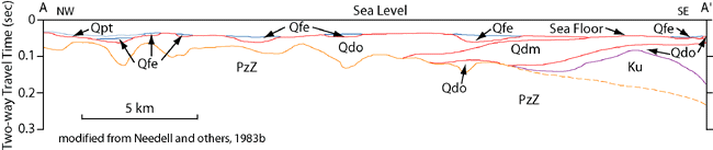
Figure 3. Interpreted stratigraphy profile across Rhode Island Sound, modified from Needell and others (1983b). Stratigraphy includes: PzZ – pre-Mesozoic bedrock, Ku – mostly late Cretaceous coastal plain and continental shelf sediments, Qdo – mostly late Wisconsin glacial drift, Qdm – late Wisconsin moraine deposits, Qfe – Holocene transitional (fluvial and estuarine) deposits, Qpt – Holocene marine sediments. Contacts are dashed where inferred. Vertical exaggeration: 19X. Location of profile shown in fig. 1. | ||

