
Woods Hole Science Center
Sidescan-Sonar Imagery and Surficial Geologic Interpretations of the Sea Floor in Central Rhode Island Sound
![]() Title |
Introduction |
Geologic Setting |
Data Acquisition/Processing |
Bathymetry |
Seismic Reflection Data |
Sidescan Sonar Imagery |
Environments |
Discussion |
Summary |
GIS Data Catalog |
Acknowledgments |
References |
Figures |
Contacts
Title |
Introduction |
Geologic Setting |
Data Acquisition/Processing |
Bathymetry |
Seismic Reflection Data |
Sidescan Sonar Imagery |
Environments |
Discussion |
Summary |
GIS Data Catalog |
Acknowledgments |
References |
Figures |
Contacts
 |
||
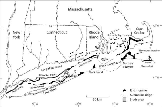
Figure 4. Map showing the location of end moraines (black polygons) in southern New England and Long Island, New York. The Ronkonkoma-Nantucket moraine represents the Laurentide Ice Sheet's maximum glacial advance about 20 ka and the Harbor Hill-Roanoke Point-Charlestown-Buzzards Bay moraine represents a retreated ice sheet position from around 18 ka (Uchupi and others, 1996). Underwater extensions of the moraines are shown as dashed lines. Study area is shown as gray polygon. Modified from Gustavson and Boothroyd (1987). | ||

