 |
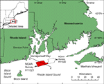
Figure 1. Location map of NOAA Survey H11321 study area in Rhode Island Sound (red polygon). NOAA Survey H11320 (McMullen and others, 2007) overlaps the eastern end of the study area (black outline). Location of interpreted stratigraphy profile A-A' (fig. 3) is also shown.
|
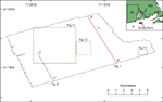 |
Figure 2. Map showing the outline of the study area (black outline), locations of historic seismic-reflection data shown in figures 7 and 8 (red lines), the locations of detailed views shown in figures 11, 12, and 13 (green outlines), and the location of a sand sample (yellow circle) from the NOS Hydrographic Database (Poppe and others, 2003). |
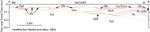 |
Figure 3. Interpreted stratigraphy profile across Rhode Island Sound, modified from Needell and others (1983b). Stratigraphy includes: PzZ - pre-Mesozoic bedrock, Ku - mostly late Cretaceous coastal plain and continental shelf sediments, Qdo - mostly late Wisconsin glacial drift, Qdm - late Wisconsin moraine deposits, Qfe - Holocene transitional (fluvial and estuarine) deposits, Qpt - Holocene marine sediments. Contacts are dashed where inferred. Vertical exaggeration: 19X. Location of profile shown in fig. 1. |
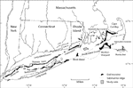 |
Figure 4. Map showing the location of end moraines (black polygons) in southern New England and Long Island, New York. The Ronkonkoma-Nantucket moraine represents the Laurentide Ice Sheet's maximum glacial advance about 20 ka and the Harbor Hill-Roanoke Point-Charlestown-Buzzards Bay moraine represents a retreated ice sheet position from around 18 ka (Uchupi and others, 1996). Underwater extensions of the moraines are shown as dashed lines. Study area is shown as gray polygon. Modified from Gustavson and Boothroyd (1987).
|
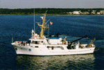 |
Figure 5. Photo of NOAA Ship RUDE (courtesy of NOAA).
|
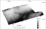 |
Figure 6. Bathymetric image of study area from sounding and multibeam data. Light tones represent shallower depths and dark tones represent deeper areas. A ridge is located across the northern and western parts of the study area. A channel is located south of the ridge and north and west of a bathymetric high in the southeast. Another bathymetric low is located in the southeastern corner of the study area. |
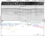 |
Figure 7. Seismic-reflection profile across eastern end of study area from Needell and others (1983a) with interpretation and corresponding sidescan-sonar image. Paleozoic bedrock, Wisconsin glacial drift including till, moraine, and glaciolacustrine sediments, and Holocene marine and transitional deposits are shown. Stratified drift in the south may be glaciolacustrine sediment. Sidescan-sonar image shows areas of sand waves, benches, trawl marks, and high backscatter. Benches tend to coincide with a contact between glaciolacustrine sediment and till. Depths are based on an assumed compressional wave velocity of 1500 m/s. Vertical exaggeration: 13X. Location of profile shown in fig. 2.
|
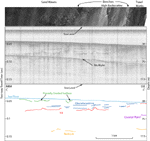 |
Figure 8. Seismic-reflection profile across western end of study area from Needell and others (1983a) with interpretation and corresponding sidescan-sonar image. Interpretation includes: Paleozoic bedrock, possible Cretaceous coastal plain sediments, Wisconsin glacial till and glaciolacustrine sediments, and Holocene marine and transitional deposits. Sidescan-sonar image shows sand waves in the north and benches, high backscatter, and trawl marks in the south. Benches occur at the contact between fluvial and glaciolacustrine sediments and within the glaciolacustrine sediment near the exposure of till. Depths are based on an assumed compressional wave velocity of 1500 m/s. Vertical exaggeration: 13X. Location of profile shown in fig. 2.
|
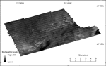 |
Figure 9. Sidescan-sonar image of the study area. Dark tones represent lower backscatter and generally finer grained sediment; light tones represent higher backscatter and generally coarser grained sediment. Light and dark bands oriented northeast-southwest are artifacts of the sidescan-sonar processing. |
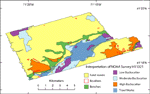 |
Figure 10. Interpretation of sidescan-sonar imagery of the study area. Sand waves are visible across much of the study area, and boulders are scattered throughout. Two lines of benches cross the study area, large areas of high backscatter are located mostly in the south, and low backscatter and trawl marks are seen in the deeper waters. |
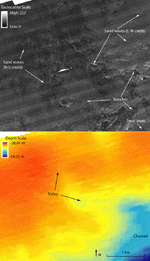 |
Figure 11. Detailed sidescan-sonar and bathymetry images of sand waves along a valley on the northern ridge. Sand waves adjacent to the valley are straight-crested and oriented north-south; away from the valley sand waves have more curved and sinuous crests that are oriented east-west. In the valley in the central part of the image, both east-west and north-south oriented sand waves are present, suggesting complex flow and transport directions. Benches are also visible on the sidescan-sonar image where there is a sharp curvilinear change in backscatter. A trawl mark is visible in the southeastern corner of the sidescan-sonar image. Location of figure shown in fig. 2. |
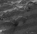 |
Figure 12. Detailed sidescan-sonar image of trawl marks on the floor of the channel. Lines of low backscatter or paired high and low backscatter indicate trawl marks. Benches cross the northern part of the image where there is a sharp curvilinear change in backscatter and sand waves are located throughout the north. An area of low backscatter indicates finer grained sediment. Location of figure shown in fig. 2.
|
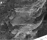 |
Figure 13. Detailed sidescan-sonar image of the southeastern part of the study area showing boulders, sand waves, and benches. Boulders are visible as high-backscatter targets with low-backscatter shadows. Higher backscatter (lighter tones) in the center of the image represents coarser grained sediment; lower backscatter (darker tones) represents finer grained sediment. Location of figure shown in fig. 2.
|
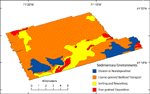 |
Figure 14. Map of the sedimentary environments in the study area including those characterized by processes of erosion or nondeposition, coarse-grained bedload transport, sorting and reworking, and fine-grained deposition.
|

