
Woods Hole Science Center
Interpolation of Reconnaissance Multibeam and Single-Beam Bathymetry Offshore of Milford, Connecticut
![]() Title |
Introduction |
Methods |
Reconnaissance Bathymetry |
Interpolated Bathymetry |
GIS Data Catalog |
Acknowledgments |
References |
List of Figures |
Contacts
Title |
Introduction |
Methods |
Reconnaissance Bathymetry |
Interpolated Bathymetry |
GIS Data Catalog |
Acknowledgments |
References |
List of Figures |
Contacts
 |
||
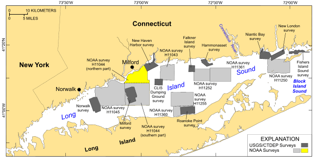
Figure 1. Map showing location of the interpolated bathymetry from the northern part of National Oceanic and Atmospheric Administration (NOAA) survey H11044 (yellow polygon). Sidescan-sonar imagery from this survey was interpreted by McMullen and others (2005); bathymetry from the southern part of this survey was interpolated and released by Poppe and others (2006a). Also shown are the sites of other NOAA bathymetric surveys (light gray polygons) and U.S. Geological Survey/Connecticut Department of Environmental Protection (USGS/CT-DEP) sidescan-sonar surveys (dark gray polygons) in Long Island Sound. Multibeam surveys: H11250 -- Poppe and others (2006b, 2007a); H11255 -- Poppe and others (2006c); H11252/H11361 -- Poppe and others (2007b, 2008). Sidescan-sonar surveys: Norwalk -- Twichell and others (1997); Milford -- Twichell and others (1998); New Haven harbor and CLIS dumping grounds -- Poppe and others (2001); Roanoke Point -- Poppe and others (1999a); Falkner Island -- Poppe and others (1999b); Hammonasset -- Poppe and others (1997); Niantic Bay -- Poppe and others (1998a); New London -- Zajac and others (2000, 2003); Fishers Island Sound -- Poppe and others (1998b); H11043 -- Poppe and others (2004); H11045 -- Beaulieu and others (2005). | ||


