Skip USGS links group
USGS - science for a changing world
NOAA logo with link to NOAA home page

Woods Hole Science Center

End of USGS links group

Bathymetry

Skip past contents information
Bathymetry
Click on figure for larger image
Figure 6. Bathymetric image of National Oceanic and Atmospheric Administration survey H11322 in western Rhode Island Sound.

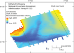
The study area consists of bathymetric highs, located in the northwest, southwest, and northeast, and a system of elongate, interconnected bathymetric lows that deepen southward and westward (fig. 6). The lows trend toward the southwest between the northern highs and toward the west in the south. The northwestern high is the shallowest part of the study area, with depths as shallow as 25 m. The northeastern high, where depths are as shallow as 29 m, contains a shallow depression about 35 m deep that is oriented north-northwest to south-southeast. The southwestern part of the channel system, where depths reach as much as 40 m, is the deepest part of the study area.

Skip Navigation

Accessibility FOIA Privacy Policies and Notices

U.S. Department of the Interior | U.S. Geological Survey | Coastal and Marine Geology

URL: cmgds.marine.usgs.gov/publications/of2008-1181/html/bathy.html
Page Contact Information: CMGDS Team
Page Last Modified: Wednesday, 06-Dec-2017 13:22:49 EST