Woods Hole Science Center
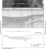
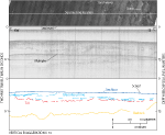
Sidescan-sonar imagery along with bathymetric and seismic-reflection data are useful in interpreting sea-floor geology. The bathymetry in the study area is related to the underlying stratigraphy. Erosional outliers and scarps, which are also found east of the study area, are the results of a lower sea level stand and the various paleoenvironments in the area. Sand waves on the sea floor are used to infer directions of net sediment transport. The bathymetry in the study area is a surficial expression of the underlying geology. Bathymetric highs are associated with glacial drift, including glaciolacustrine sediments in the east (fig. 8). Linear bathymetric lows in the study area overlie and are surface expressions of the westward-draining fluvial channels that were partially filled during subaerial exposure (fig. 7). In the west, fluvial and estuarine sediments extend from the channel across the southern flank of the bathymetric high and form erosional outliers. Features with the same backscatter characteristics as the erosional outliers in the western part of the study area were also identified in eastern Rhode Island Sound. These erosional outliers to the east, visible in high-resolution multibeam bathymetry as small plateaus about 0.5 m high, occur over stratified sediments that were interpreted to consist of glaciolacustrine deposits (McMullen and others, 2007). The erosional outliers in the present study area likely consist of fluvial and estuarine sediments that presumably continue from the channel onto the flank of the bathymetric high, as there is no well-defined northern boundary of these sediments (fig. 7). Glaciolacustrine sediments may be located on the bathymetric high and form these outliers; however, well-stratified sediments are not distinguishable in the seismic-reflection profiles. The outliers in both locations were probably formed in the same way; the more readily erodible sediment was removed, leaving plateaus of the more cohesive sediments. The scarps, hills, and benches, which are at depths of 35 to 37 m, are probably records of a paleoshoreline. These features stretch across Rhode Island Sound in a curvilinear pattern parallel to the present shoreline at a relatively constant depth that becomes slightly shallower to the east (McMullen and others, 2007; 2008). The morphologies and depth of the scarps, hills, and benches are similar to those of paleoshorelines found in nearby areas, which have been previously dated based on sea-level-rise curves. In Long Island Sound, paleoshoreline features including small steps, lensoidal beach deposits, and erosional benches or terraces have been found at 37 to 38 m and were suggested to have formed 10,000 to 10,500 years ago (Gayes and Bokuniewicz, 1991). A 15-m-high, 1.5-km-wide, mid-shelf scarp located off New Jersey in water depths between 37 and 52 m was interpreted as a shoreline that formed around 10,500 years ago (Duncan and others, 2000). Although it is shallower than the features in our study area, a submerged barrier spit at 24 m was interpreted to represent a paleoshoreline from 8,300 to 9,000 years ago southwest of the study area, off the southern coast of Block Island (McMaster and Garrison, 1967). The scarps identified in Rhode Island Sound are thought be coeval with the paleoshoreline features in Long Island Sound and off the New Jersey coast due to their similar depths. Sand-wave orientation in the study area is used to determine net sediment-transport directions, as water currents in the study area are not known. Sand waves in the northeastern part of the study area are generally oriented with their crests perpendicular to the sea-floor gradient. Therefore, net sediment transport is most likely parallel to the slope in this area. However, sand-wave crests on the northwestern bathymetric high are oriented parallel to the bathymetric gradient, implying that net sediment transport is around the high and that the sediment transport may be helping to maintain the feature. |