Woods Hole Science Center
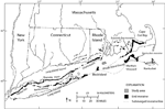
Glacial sediments that were reworked as a result of marine transgression during the Holocene Epoch dominate the Rhode Island Sound sea floor. The stratigraphy in the sound consists of a Paleozoic basement of mostly gneiss and schist overlain by Cretaceous Coastal Plain sediments in the south and Pleistocene glacial drift and Holocene deposits throughout the Sound (fig. 3; McMaster, 1960; McMaster and others, 1968; Needell and others, 1983a). The northern boundary of the Cretaceous Coastal Plain sediments forms a northward-facing cuesta that crosses the sound (McMaster and others, 1968; Needell and others, 1983a). The southern extent of the glacial deposits is marked by the Ronkonkoma-Block Island-Nantucket end moraine, dating to about 20,000 years ago, whereas a retreated ice position, dating to about 18,000 years ago, is represented by the Harbor Hill-Roanoke Point-Charlestown-Buzzards Bay moraine (fig. 4; Uchupi and others, 1996). During glacial recession, pro-glacial lakes formed between the previous morainal position and the retreating ice front in present Long Island Sound, Block Island Sound, and Narragansett Bay (Uchupi and others, 2001). The glacial lakes also extended into Rhode Island Sound (Needell and others, 1983a). During and after lake drainage, the area occupied by the present-day shelf was exposed to subaerial erosion, and fluvial channels cut into the glacial drift (Needell and others, 1983a). As sea level rose, Holocene marine and transgressive sediment sequences including fluvial, estuarine, and beach sediments were deposited and subsequently reworked and eroded by waves and currents (Needell and others, 1983a). |