USGS Coastal and Marine Geology Program
Geophysical Data from Offshore of the Chandeleur Islands, Eastern Mississippi Delta
|
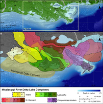
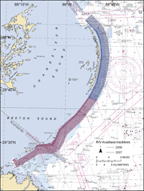
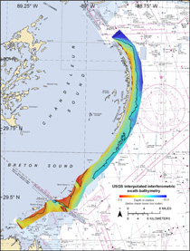
The Chandeleur barrier-island chain borders the Mississippi Delta in eastern Louisiana. It protects the fragile wetland ecosystems of Chandeleur and Breton Sounds and the “urban estuary” of Lake Pontchartrain, which borders the city of New Orleans, La., from the open waters of the Gulf of Mexico (fig. 1; Penland and others, 2002). The islands were decimated in 2005 when their surface area was reduced by 84 percent during Hurricane Katrina (Sallenger and others, 2006). Recovery has been limited since the hurricane and it is unclear whether the islands will continue to recover naturally, require restoration engineering, or eventually evolve into submerged shoals. The Chandeleur Islands rest on top of the St. Bernard sublobe of the Mississippi Delta (fig. 1). This sublobe began to develop about 4,600 yr BP and was abandoned by about 1,800 yr BP (Frazier, 1967). The islands are suggested to have formed as a barrier-island arc attached to a headland during the final stages of St. Bernard sublobe growth (Penland and others, 1985). Once the sublobe was abandoned, rapid relative sea-level rise caused the barrier-island chain to become detached from its headland source, leaving it isolated within the shallow waters of Chandeleur and Breton Sounds. The combined effects of eustacy and high subsidence rates have resulted in particularly high rates of relative sea-level rise across the Mississippi Delta. The future of the Chandeleur Islands is uncertain. If sand supply is sufficient, they likely will continue to maintain a subaerial presence, however, if sand supply is inadequate, storms will overwhelm the islands and transform them into submerged shoals. In order to assess the fate of the Chandeleur Islands, we need to understand the geologic framework upon which they are built, the volume and distribution of sand associated with them, and the processes that shape the surrounding seafloor. The U.S. Geological Survey (USGS) and the Louisiana Department of Natural Resources have funded a cooperative study between the USGS and the University of New Orleans that aims to achieve these goals. This report presents a collection of compilation of the geophysical and geospatial data acquired during the offshore-mapping component of the cooperative study. A dense grid of more than 4,000 km of geophysical tracklines (fig. 2), covering approximately 500 km2, was occupied seaward of the Chandeleur Islands during two cruises in July 2006 and June 2007. Surface and subsurface geophysical data were acquired with the following equipment: a Systems Engineering and Assessment (SEA), Ltd., SwathPlus interferometric sonar; a Klein 3000 dual-frequency sidescan sonar; and an EdgeTech 512i chirp sub-bottom profiling system. The long-term goal of the offshore-mapping effort is to produce high-quality, high-resolution geologic data, maps, and interpretations that can be utilized to investigate the impact of Hurricane Katrina, identify sand resources within the region, and make predictions regarding the future evolution of this coastal system (fig. 3). This report documents the data-processing procedures employed, and presents processed bathymetric, sidescan-sonar, and seismic data sets in a geographic information system (GIS) that will serve as the foundation for future interpretive reports.
|