USGS Coastal and Marine Geology Program
Sea Floor Image Maps Showing Topography, Sun-Illuminated Topography, Backscatter Intensity, Ruggedness, Slope, and the Distribution of Boulder Ridges and Bedrock Outcrops in the Stellwagen Bank National Marine Sanctuary Region off Boston, Massachusetts
|
|||||||||||||||||||||||||||||||
|
Page C. Valentine, editor
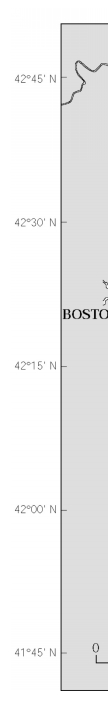
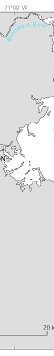
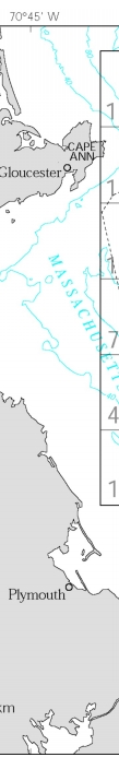
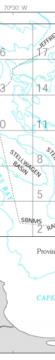
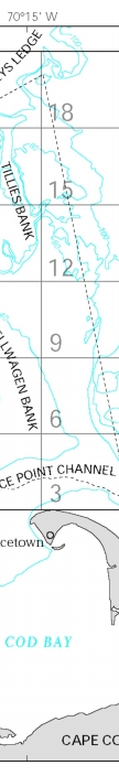
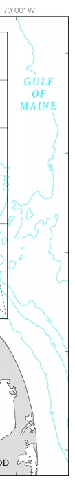
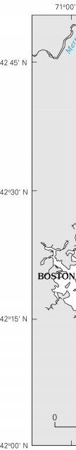
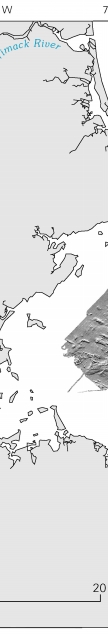
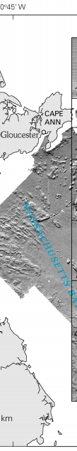
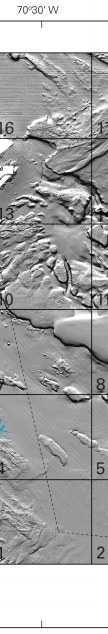
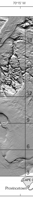
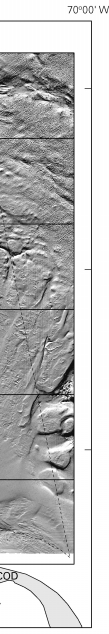
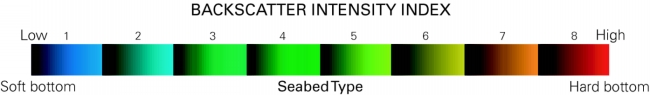
DiscussionIntroduction Sea floor mapping in the Stellwagen Bank National Marine Sanctuary (NMS) is a cooperative effort of the U.S. Geological Survey (USGS) and the National Oceanic and Atmospheric Administration, with technical support from the University of New Brunswick and the Canadian Hydrographic Service. The maps generated from this undertaking are based on a 1994–96 survey that used a multibeam echo sounder to map 1,100 square nautical miles of the sea floor (fig. 1). The technology and methods of image acquisition and topographic contouring that were used are described in publication 4 in the References section. USGS Scientific Investigations Maps (SIM) 2840–A to –F constitute a six-map (twelve-sheet) series in digital (DVD-ROM) format. The first three maps, SIM 2840–A, –B, and –C, were previously published on paper as USGS Geologic Investigations Series Maps I–2676–A, –B, and –C (publications 43–45 in the References). Preliminary versions of those three maps also had been released earlier on a CD-ROM as USGS Open-File Report 00–410 (publication 42). Backscatter intensity This map combines contoured and sun-illuminated topography with backscatter intensity of the sea floor. Backscatter intensity is an indicator of sea floor hardness and roughness as determined by the strength of the sound waves reflected from the seabed during the survey. It is depicted here by a suite of eight colors (fig. 3) ranging from blue, which represents low intensity (soft bottom), to red, which represents high intensity (hard bottom). The mapped backscatter intensity data are draped over a shaded relief image created by vertically exaggerating the topography four times and artificially illuminating the relief by a light source positioned 45 degrees above the horizon from an azimuth of 350 degrees. The resulting image displays light and dark tones within each color band that are determined by a feature's position with respect to the light source. For example, north-facing slopes, receiving strong illumination, show as light tones within a color band, whereas south-facing slopes, being in shadow, show as dark tones within a color band. The interpretation of backscatter intensity is based on numerous sediment texture analyses and video and photographic imagery of the sea floor in the mapped area (see Map F, Sheet 3 of this series for location of stations). High backscatter values (6-7-8, yellow-orange-red) represent coarse sand, gravelly sand, sandy gravel, gravel (including ridges and piles of boulders), and rock outcrops. Moderate backscatter values (3-4-5, green-yellow) represent sand and muddy sand, and low backscatter values (1-2, blue) represent sandy mud and mud. These interpretations are most accurate in regions of relatively low relief, because steep slopes can divert the paths of some of the reflected sound waves away from the survey vessel. Thus, seabed that slopes steeply away from the survey track can produce a lower backscatter intensity than if the seabed were level. For example, the conical crest of Sanctuary Hill (Quadrangles 17 and 18) is a bedrock outcrop that should display high backscatter values (6-7-8) but here displays moderate values (3-4-5), presumably because its flanks reflect sound waves in many directions, reducing the sound energy returned to the receiver. Conversely, seabed that slopes steeply toward the survey track can produce a higher backscatter intensity. Those areas that show relatively uniform backscatter intensity imply homogeneity of bottom sediment. However, in other places variable backscatter intensity implies a more heterogeneous composition of bottom sediment. Unnatural-looking stripes and patterns oriented parallel or perpendicular to survey tracklines are artifacts of data collection. References USGS publications can also be purchased from USGS Information Services, Box 25286, Denver Federal Center, Denver, CO 80225-0046; telephone (303) 202-4200 or 1-888-ASK-USGS Massachusetts Bay Disposal Site—Maps and Features 1. Valentine, P.C., Baker, J.L., Unger, T.S., Evans, John, and Polloni, C.F., 1999, Sea floor topographic, backscatter, and interpretive maps and bottom photos of the Massachusetts Bay Disposal Site region off Boston, Massachusetts: U.S. Geological Survey Open-File Report 98–344, 1 CD-ROM. (Also available online at http://pubs.usgs.gov/of/of98-344/) 2. Valentine, P.C., Danforth, W.W., Roworth, E.T., and Stillman, S.T., 1996, Maps showing topography, backscatter, and interpretation of sea floor features in the Massachusetts Bay Disposal Site region off Boston, Massachusetts: U.S. Geological Survey Open-File Report 96–273, 2 sheets, scale 1:10,000 and 1:12,500. Massachusetts and Cape Cod Bays and Stellwagen Bank National Marine Sanctuary—Sea Floor Topography 3. Valentine, P.C., Schmuck, E.A., Signell, R.P., and Ryland, C.A., 1995, Sea floor topography of Massachusetts and Cape Cod Bays and Stellwagen Bank National Marine Sanctuary: U.S. Geological Survey Open-File Report 95–073, scale 1:100,000. Stellwagen Bank National Marine Sanctuary—Sea Floor Topography 4. Valentine, P.C., Baker, J.L., Unger, T.S., and Polloni, C.F., 1998, Sea floor topographic map and perspective-view imagery of Quadrangles 1–18, Stellwagen Bank National Marine Sanctuary off Boston, Massachusetts: U.S. Geological Survey Open-File Report 98–138, 1 CD-ROM. (Also available online at http://pubs.usgs.gov/of/of98-138/) 5. Valentine, P.C., Baker, J.L., Unger, T.S., and Roworth, E.T., 1997, Sea floor topography of Quadrangle 1 in the Stellwagen Bank National Marine Sanctuary off Boston, Massachusetts: U.S. Geological Survey Open-File Report 97–502, scale 1:25,000. 6. Valentine, P.C., Unger, T.S., Baker, J.L., and Roworth, E.T., 1997, Sea floor topography of Quadrangle 2 in the Stellwagen Bank National Marine Sanctuary off Boston, Massachusetts: U.S. Geological Survey Open-File Report 97–503, scale 1:25,000. 7. Valentine, P.C., Baker, J.L., Unger, T.S., and Roworth, E.T., 1997, Sea floor topography of Quadrangle 3 in the Stellwagen Bank National Marine Sanctuary off Boston, Massachusetts: U.S. Geological Survey Open-File Report 97–504, scale 1:25,000. 8. Valentine, P.C., Unger, T.S., Baker, J.L., and Roworth, E.T., 1997, Sea floor topography of Quadrangle 4 in the Stellwagen Bank National Marine Sanctuary off Boston, Massachusetts: U.S. Geological Survey Open-File Report 97–505, scale 1:25,000. 9. Valentine, P.C., Baker, J.L., Unger, T.S., and Roworth, E.T., 1997, Sea floor topography of Quadrangle 5 in the Stellwagen Bank National Marine Sanctuary off Boston, Massachusetts: U.S. Geological Survey Open-File Report 97–506, scale 1:25,000. 10. Valentine, P.C., Unger, T.S., Baker, J.L., and Roworth, E.T., 1997, Sea floor topography of Quadrangle 6 in the Stellwagen Bank National Marine Sanctuary off Boston, Massachusetts: U.S. Geological Survey Open-File Report 97–507, scale 1:25,000. 11. Valentine, P.C., Baker, J.L., Unger, T.S., and Roworth, E.T., 1997, Sea floor topography of Quadrangle 7 in the Stellwagen Bank National Marine Sanctuary off Boston, Massachusetts: U.S. Geological Survey Open-File Report 97–508, scale 1:25,000. 12. Valentine, P.C., Unger, T.S., Baker, J.L., and Roworth, E.T., 1997, Sea floor topography of Quadrangle 8 in the Stellwagen Bank National Marine Sanctuary off Boston, Massachusetts: U.S. Geological Survey Open-File Report 97–509, scale 1:25,000. 13. Valentine, P.C., Baker, J.L., Unger, T.S., and Roworth, E.T., 1997, Sea floor topography of Quadrangle 9 in the Stellwagen Bank National Marine Sanctuary off Boston, Massachusetts: U.S. Geological Survey Open-File Report 97–682, scale 1:25,000. 14. Valentine, P.C., Unger, T.S., Baker, J.L., and Roworth, E.T., 1997, Sea floor topography of Quadrangle 10 in the Stellwagen Bank National Marine Sanctuary off Boston, Massachusetts: U.S. Geological Survey Open-File Report 97–683, scale 1:25,000. 15. Valentine, P.C., Baker, J.L., Unger, T.S., and Roworth, E.T., 1997, Sea floor topography of Quadrangle 11 in the Stellwagen Bank National Marine Sanctuary off Boston, Massachusetts: U.S. Geological Survey Open-File Report 97–684, scale 1:25,000. 16. Valentine, P.C., Unger, T.S., Baker, J.L., and Roworth, E.T., 1997, Sea floor topography of Quadrangle 12 in the Stellwagen Bank National Marine Sanctuary off Boston, Massachusetts: U.S. Geological Survey Open-File Report 97–685, scale 1:25,000. 17. Valentine, P.C., Baker, J.L., Unger, T.S., and Roworth, E.T., 1997, Sea floor topography of Quadrangle 13 in the Stellwagen Bank National Marine Sanctuary off Boston, Massachusetts: U.S. Geological Survey Open-File Report 97–726, scale 1:25,000. 18. Valentine, P.C., Unger, T.S., Baker, J.L., and Roworth, E.T., 1997, Sea floor topography of Quadrangle 14 in the Stellwagen Bank National Marine Sanctuary off Boston, Massachusetts: U.S. Geological Survey Open-File Report 97–727, scale 1:25,000. 19. Valentine, P.C., Baker, J.L., Unger, T.S., and Roworth, E.T., 1997, Sea floor topography of Quadrangle 15 in the Stellwagen Bank National Marine Sanctuary off Boston, Massachusetts: U.S. Geological Survey Open-File Report 97–728, scale 1:25,000. 20. Valentine, P.C., Unger, T.S., Baker, J.L., and Roworth, E.T., 1997, Sea floor topography of Quadrangle 16 in the Stellwagen Bank National Marine Sanctuary off Boston, Massachusetts: U.S. Geological Survey Open-File Report 97–729, scale 1:25,000. 21. Valentine, P.C., Baker, J.L., Unger, T.S., and Roworth, E.T., 1997, Sea floor topography of Quadrangle 17 in the Stellwagen Bank National Marine Sanctuary off Boston, Massachusetts: U.S. Geological Survey Open-File Report 97–730, scale 1:25,000. 22. Valentine, P.C., Unger, T.S., Baker, J.L., and Roworth, E.T., 1997, Sea floor topography of Quadrangle 18 in the Stellwagen Bank National Marine Sanctuary off Boston, Massachusetts: U.S. Geological Survey Open-File Report 97–731, scale 1:25,000. Stellwagen Bank National Marine Sanctuary—Sun-Illuminated Sea Floor Topographic Imagery 23. Valentine, P.C., Unger, T.S., Baker, J.L., and Polloni, C.F., 2000, Sun-illuminated sea floor topographic maps and perspective-view imagery of Quadrangles 1–18, Stellwagen Bank National Marine Sanctuary off Boston, Massachusetts: U.S. Geological Survey Open-File Report 99–363, 1 CD-ROM. (Also available online at http://pubs.usgs.gov/of/of99-363/) 24. Valentine, P.C., Baker, J.L., and Unger, T.S., 2000, Sun-illuminated sea floor topography of Quadrangle 1 in the Stellwagen Bank National Marine Sanctuary off Boston, Massachusetts: U.S. Geological Survey Geologic Investigations Series Map I–2701, scale 1:25,000. 25. Valentine, P.C., Unger, T.S., and Baker, J.L., 1999, Sun-illuminated sea floor topography of Quadrangle 2 in the Stellwagen Bank National Marine Sanctuary off Boston, Massachusetts: U.S. Geological Survey Geologic Investigations Series Map I–2702, scale 1:25,000. 26. Valentine, P.C., Baker, J.L., and Unger, T.S., 1999, Sun-illuminated sea floor topography of Quadrangle 3 in the Stellwagen Bank National Marine Sanctuary off Boston, Massachusetts: U.S. Geological Survey Geologic Investigations Series Map I–2703, scale 1:25,000. 27. Valentine, P.C., Unger, T.S., and Baker, J.L., 2000, Sun-illuminated sea floor topography of Quadrangle 4 in the Stellwagen Bank National Marine Sanctuary off Boston, Massachusetts: U.S. Geological Survey Geologic Investigations Series Map I–2704, scale 1:25,000. 28. Valentine, P.C., Baker, J.L., and Unger, T.S., 1999, Sun-illuminated sea floor topography of Quadrangle 5 in the Stellwagen Bank National Marine Sanctuary off Boston, Massachusetts: U.S. Geological Survey Geologic Investigations Series Map I–2705, scale 1:25,000. 29. Valentine, P.C., Unger, T.S., and Baker, J.L., 1999, Sun-illuminated sea floor topography of Quadrangle 6 in the Stellwagen Bank National Marine Sanctuary off Boston, Massachusetts: U.S. Geological Survey Geologic Investigations Series Map I–2706, scale 1:25,000. 30. Valentine, P.C., Baker, J.L., and Unger, T.S., 1999, Sun-illuminated sea floor topography of Quadrangle 7 in the Stellwagen Bank National Marine Sanctuary off Boston, Massachusetts: U.S. Geological Survey Geologic Investigations Series Map I–2707, scale 1:25,000. 31. Valentine, P.C., Unger, T.S., and Baker, J.L., 1999, Sun-illuminated sea floor topography of Quadrangle 8 in the Stellwagen Bank National Marine Sanctuary off Boston, Massachusetts: U.S. Geological Survey Geologic Investigations Series Map I–2708, scale 1:25,000. 32. Valentine, P.C., Baker, J.L., and Unger, T.S., 2000, Sun-illuminated sea floor topography of Quadrangle 9 in the Stellwagen Bank National Marine Sanctuary off Boston, Massachusetts: U.S. Geological Survey Geologic Investigations Series Map I–2709, scale 1:25,000. 33. Valentine, P.C., Unger, T.S., and Baker, J.L., 2000, Sun-illuminated sea floor topography of Quadrangle 10 in the Stellwagen Bank National Marine Sanctuary off Boston, Massachusetts: U.S. Geological Survey Geologic Investigations Series Map I–2710, scale 1:25,000. 34. Valentine, P.C., Baker, J.L., and Unger, T.S., 2000, Sun-illuminated sea floor topography of Quadrangle 11 in the Stellwagen Bank National Marine Sanctuary off Boston, Massachusetts: U.S. Geological Survey Geologic Investigations Series Map I–2711, scale 1:25,000. 35. Valentine, P.C., Unger, T.S., and Baker, J.L., 2000, Sun-illuminated sea floor topography of Quadrangle 12 in the Stellwagen Bank National Marine Sanctuary off Boston, Massachusetts: U.S. Geological Survey Geologic Investigations Series Map I–2712, scale 1:25,000. 36. Valentine, P.C., Baker, J.L., and Unger, T.S., 2001, Sun-illuminated sea floor topography of Quadrangle 13 in the Stellwagen Bank National Marine Sanctuary off Boston, Massachusetts: U.S. Geological Survey Geologic Investigations Series Map I–2713, scale 1:25,000. 37. Valentine, P.C., Unger, T.S., and Baker, J.L., 2001, Sun-illuminated sea floor topography of Quadrangle 14 in the Stellwagen Bank National Marine Sanctuary off Boston, Massachusetts: U.S. Geological Survey Geologic Investigations Series Map I–2714, scale 1:25,000. 38. Valentine, P.C., Baker, J.L., and Unger, T.S., 2001, Sun-illuminated sea floor topography of Quadrangle 15 in the Stellwagen Bank National Marine Sanctuary off Boston, Massachusetts: U.S. Geological Survey Geologic Investigations Series Map I–2715, scale 1:25,000. 39. Valentine, P.C., Unger, T.S., and Baker, J.L., 2001, Sun-illuminated sea floor topography of Quadrangle 16 in the Stellwagen Bank National Marine Sanctuary off Boston, Massachusetts: U.S. Geological Survey Geologic Investigations Series Map I–2716, scale 1:25,000. 40. Valentine, P.C., Baker, J.L., and Unger, T.S., 2001, Sun-illuminated sea floor topography of Quadrangle 17 in the Stellwagen Bank National Marine Sanctuary off Boston, Massachusetts: U.S. Geological Survey Geologic Investigations Series Map I–2717, scale 1:25,000. 41. Valentine, P.C., Unger, T.S., and Baker, J.L., 2001, Sun-illuminated sea floor topography of Quadrangle 18 in the Stellwagen Bank National Marine Sanctuary off Boston, Massachusetts: U.S. Geological Survey Geologic Investigations Series Map I–2718, scale 1:25,000. Stellwagen Bank National Marine Sanctuary—Sun-Illuminated Sea Floor Topographic Imagery and Backscatter Intensity 42. Valentine, P.C., Middleton, T.J., and Fuller, S.J., 2001, Sea floor maps showing topography, sun-illuminated topography, and backscatter intensity of the Stellwagen Bank National Marine Sanctuary region off Boston, Massachusetts: U.S. Geological Survey Open-File Report 00–410, 1 CD-ROM. (Also available online at http://pubs.usgs.gov/of/of00-410/) (Superseded by maps I–2676–A, –B, and –C; see publications 43–45 in this list.) 43. Valentine, P.C., Baker, J.L., and Unger, T.S., 2003, Sea floor topography of the Stellwagen Bank National Marine Sanctuary off Boston, Massachusetts: U.S. Geological Survey Geologic Investigations Series Map I–2676–A, scale 1:60,000. 44. Valentine, P.C., Unger, T.S., and Baker, J.L., 2003, Sun-illuminated sea floor topography of the Stellwagen Bank National Marine Sanctuary off Boston, Massachusetts: U.S. Geological Survey Geologic Investigations Series Map I–2676–B, scale 1:60,000. 45. Valentine, P.C., Unger, T.S., and Baker, J.L., 2003, Backscatter intensity and sun-illuminated sea floor topography of the Stellwagen Bank National Marine Sanctuary off Boston, Massachusetts: U.S. Geological Survey Geologic Investigations Series Map I–2676–C, scale 1:60,000. Stellwagen Bank National Marine Sanctuary—Seabed Ruggedness and Distribution of Boulder Ridges and Bedrock Outcrops 46. Valentine, P.C., Fuller, S.J., and Scully, L.A. [2004], Terrain ruggedness analysis and distribution of boulder ridges and bedrock outcrops in the Stellwagen Bank National Marine Sanctuary region—seabed ruggedness: U.S. Geological Survey poster available online at http://woodshole.er.usgs.gov/project-pages/stellwagen/posters/rugged.html (Downloaded July 27, 2005.) 47. Valentine, P.C., Scully, L.A., and Fuller, S.J. [2004], Terrain ruggedness analysis and distribution of boulder ridges and bedrock outcrops in the Stellwagen Bank National Marine Sanctuary region—boulder ridges and bedrock outcrops: U.S. Geological Survey poster available online at http://woodshole.er.usgs.gov/project-pages/stellwagen/posters/ridges.html (Downloaded July 27, 2005.) Terrain Ruggedness Index (TRI) 48. Riley, S.J., DeGloria, S.D, and Elliott, R., 1999, A terrain ruggedness index that quantifies topographic heterogeneity: Intermountain Journal of Sciences, v. 5, no. 1-4, p. 23–27.
|
|||||||||||||||||||||||||||||||
| |||||||||||||||||||||||||||||||