USGS Coastal and Marine Hazards and Resources Program
Sea Floor Image Maps Showing Topography, Sun-Illuminated Topography, Backscatter Intensity, Ruggedness, Slope, and the Distribution of Boulder Ridges and Bedrock Outcrops in the Stellwagen Bank National Marine Sanctuary Region off Boston, Massachusetts
|
||||||||||||||||||||||||||
|
Page C. Valentine, editor
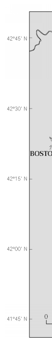
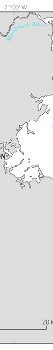
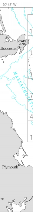
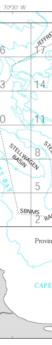
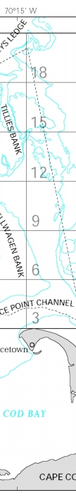
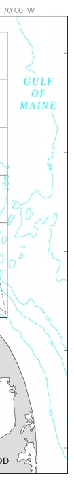
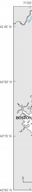
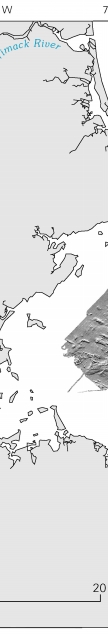
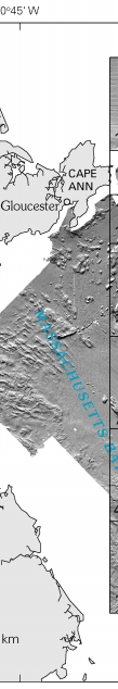
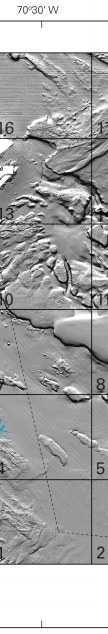
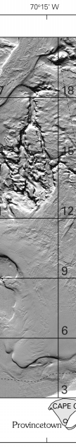
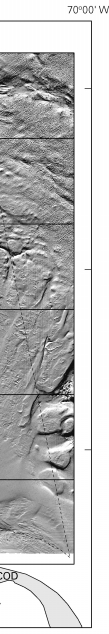
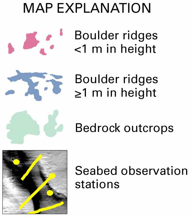
DiscussionIntroductionSea floor mapping in the Stellwagen Bank National Marine Sanctuary (NMS) is a cooperative effort of the U.S. Geological Survey (USGS) and the National Oceanic and Atmospheric Administration, with technical support from the University of New Brunswick and the Canadian Hydrographic Service. The maps generated from this undertaking are based on a 1994–96 survey that used a multibeam echo sounder to map 1,100 square nautical miles of the sea floor (fig. 1). The technology and methods of image acquisition and topographic contouring that were used are described in publication 4 in the References section. USGS Scientific Investigations Maps (SIM) 2840–A to –F constitute a six-map (twelve-sheet) series in digital (DVD-ROM) format. The first three maps, SIM 2840–A, –B, and –C, were previously published on paper as USGS Geologic Investigations Series Maps I–2676–A, –B, and –C (publications 43–45 in the References). Preliminary versions of those three maps also had been released earlier on a CD-ROM as USGS Open-File Report 00–410 (publication 42). The map area shown here is a composite of 18 individual quadrangle maps (fig. 1). Two map series of the 18 quadrangles have been published at a scale of 1:25,000 and show sea floor topography (publications 4–22) and sun-illuminated sea floor topography (fig. 2; see publications 23–41). Selected sea floor maps, photographs, CD-ROMs, fact sheets, posters, and geographic names related to research conducted in the Stellwagen Bank NMS region are available online at USGS Web site http://woodshole.er.usgs.gov/project-pages/stellwagen/index.html. See the References section for a complete numbered list of publications. On the maps presented in this series, the locations of the corners of the 18 quadrangles are shown for reference as ticks labeled outside the map edges, and (on maps C and E) as large crossticks within the map area. Maps A, B, D, and F show the boundaries of the individual quadrangles. On the maps that show sun-illuminated sea floor topography, blank spaces represent areas of no data. Distribution of boulder ridges and bedrock outcrops Description These maps show various combinations of contoured and sun-illuminated topographic imagery and the distribution of boulder ridges and bedrock outcrops (fig. 3). Boulder ridges are divided into two groups, those less than 1 m in height (shown in red), and those 1 m or greater in height (shown in blue). Ridges in the second and larger group have an average height of 2.8l m and a maximum height of 18 m. The boulder ridges primarily are elongate features (although some mounds occur as well) that are accumulations of boulders and cobbles deposited by glacial processes to form eskers and moraines. Eskers are accumulations of sand and gravel deposited by running water within or beneath stationary glacial ice. Many eskers are present in the mapped area, with particularly good examples on the top of Gloucester Bank. Moraines are deposits of rock debris (gravel, sand, and mud) piled up at the edges of moving ice. Moraines also are present throughout the map area, and examples are on the tops and upper edges of banks that lie between Northern Valley and Ellipse Bank to the west. In the present submerged environment, the sand and mud that originally filled the spaces between the cobbles and boulders of many of the eskers and moraines were transported away by shallow-water currents during the postglacial rise in sea level. As a result, the surfaces of the these ridges now are characterized by voids between the cobbles and boulders. The voids distinguish these ridges from other ridges, mounds, and hills in the region whose boulders, cobbles, and pebbles lie beneath a partial veneer of sand and mud. At present, boulder ridges lie at water depths of approximately 30 to 90 m. Bedrock outcrops (shown in green) and associated gravel deposits in the map region are limited to the coastal area off Cape Ann that extends seaward to a depth of approximately 40 m, and to four subcircular hills (Sanctuary Hill, East Hill, East and West Pigeon Hills), whose tops lie between 30 and 50 m depth. Interpretation Boulder ridges and bedrock outcrops were identified using various types of information (publication 47) that included topographic imagery, the terrain ruggedness index, or TRI (see Map D of this series and publication 47 for an explanation of the TRI), the backscatter intensity of the seabed (see Map C of this series), and information collected at 2,868 video and (or) photographic stations in the map region (see Map F, Sheet 3 of this series). The boulder ridges and bedrock outcrops mapped here have not all been inspected; most were identified by analogy with similar features that have been documented using video and photographic imagery. The boulder ridges range up to tens of meters in width and hundreds of meters in length. The relatively few mounds present range up to tens of meters in diameter. The topographic imagery and the TRI are based on digital bathymetric data having a pixel resolution of 13 x 13 m, but our geographic information system (GIS) software does not automatically recognize and delineate boulder ridges and bedrock outcrops. Some of them can be outlined by selecting closed topographic contours at their bases; but the boundaries for most features must be delineated individually and subjectively by hand. Topographic imagery shows the boulder ridges to be irregular in plan view, to have sharply defined crests, and to be situated primarily on the tops and along the upper edges of banks and valleys (for example, Gloucester, Ellipse, and Tillies Banks; Northern Valley and Triple Valley, among others). To a lesser extent, some boulder ridges are found in depressions that were formed by large stationary masses of melting glacial ice (for example, the southeastern part of Lower Stellwagen Bank). The TRI of boulder ridges lies in the >30- to 200-cm range. Backscatter intensity shows the ridges to be hard seabed. Images collected at video and photographic stations (see Sheet 3 of this map) reveal the ridges to have a rough surface of cobbles and boulders separated by voids and characterized by abrupt changes in elevation caused by the irregularity of boulder and cobble sizes. Ridges with poorly defined crests generally do not display the voids that occur where sand and mud have been removed by erosion, and their distribution has not been mapped here. Bedrock outcrops are characterized in the sun-illuminated topographic imagery by distinctively uneven surfaces and by joints and fractures that trend in many directions. The outcrop surfaces are smooth, jointed, or stepped, or have a partial veneer of cobbles, boulders, and pieces of fractured rock that are separated by voids similar to those found on the boulder ridges. The combination of hard substrate and voids that characterize boulder ridges and bedrock outcrops provides habitats that are rich in attached epifauna and groundfish, including sponges, bryozoa, hydrozoa, brachiopods, tunicates, redfish, cod, haddock, wolffish, cunner, and other species. Using GIS software, we calculated the area of the seabed represented by boulder ridge and bedrock outcrop polygons for each of the 18 quadrangles in the map area as well as for the area of the Stellwagen Bank NMS that lies in each quadrangle (table 1). In the 18-quadrangle region, 1 percent of the seabed is occupied by boulder ridges and 0.3 percent by bedrock outcrops. These values for the region as a whole also are representative of the seabed habitats within the Stellwagen Bank NMS that is outlined by the dashed line on the map. Boulder ridges occur throughout the map area but are concentrated on bank tops in water depths less than approximately 90 m. The voids between the boulders that originated during the rise of sea level in the postglacial period have remained open because there is little sediment transported into the region at present. Ridges whose cobbles and boulders have not been exposed presumably were covered by a relatively thick layer of sand and mud that was not eroded during the latest rise in sea level. Boulder ridges that are located on small banks that now lie in muddy basins (for example, Stellwagen and Scantum Basins) are more likely to display a thin veneer of fine sediment, resuspended by bottom fishing activities and natural currents, than ridges in other settings (for example, Tillies and Gloucester Banks, Jeffreys Ledge, and Ninety Meter Banks). Within the map region, boulder ridges cover 36.9 km² (table 1). Ten quadrangles (1, 4, 6, 9, 10, 12–14, 16, 17) each contain more than 2 km² of boulder ridges, with Quadrangles 9 and 10 containing the most (4.4 and 5.0 km², respectively). High concentrations of boulder ridges occur in the western part of Quadrangle 1 (off Duxbury and Marshfield, Mass.), in Quadrangle 10 (Gloucester, Ellipse, and Lower Stellwagen Banks), in Quadrangle 14 (Tillies Bank area), in the southern parts of Quadrangles 16 and 17 (southern part of Jeffreys Ledge), and in Quadrangle 9 (east of Stellwagen Bank). Bedrock outcrops (Sanctuary Hill, East Hill, East and West Pigeon Hills, and Cape Ann) are located in the northern part of the map area and lie at relatively shallow depths where strong currents prevent sediment deposition. In Quadrangles 17 and 18, bedrock outcrops occur as hills that occupy 2.3 km² (table 1). In Quadrangles 13 and 16, in the coastal area off Cape Ann, the bedrock area surveyed is 8.1 km², but much of the bedrock was not surveyed because of navigation hazards. Multibeam imagery of the seabed, when combined with video and photographic surveys, has made it possible to identify boulder ridges and bedrock outcrops that lie within a large region (3,760 km²) of sea floor. These features are unique in that they are characterized by hard seabed composed of boulders, cobbles, and rock fragments that are separated by voids. Although boulder ridges and bedrock outcrops occupy only 47.0 km² (1.3 percent) of the map area and 30.2 km² (1.4 percent) of the Stellwagen Bank NMS (table 1), they provide an important habitat for many species of juvenile and adult fish. References USGS publications can also be purchased from USGS Information Services, Box 25286, Denver Federal Center, Denver, CO 80225-0046; telephone (303) 202-4200 or 1-888-ASK-USGS Massachusetts Bay Disposal Site—Maps and Features 1. Valentine, P.C., Baker, J.L., Unger, T.S., Evans, John, and Polloni, C.F., 1999, Sea floor topographic, backscatter, and interpretive maps and bottom photos of the Massachusetts Bay Disposal Site region off Boston, Massachusetts: U.S. Geological Survey Open-File Report 98–344, 1 CD-ROM. (Also available online at http://pubs.usgs.gov/of/of98-344/) 2. Valentine, P.C., Danforth, W.W., Roworth, E.T., and Stillman, S.T., 1996, Maps showing topography, backscatter, and interpretation of sea floor features in the Massachusetts Bay Disposal Site region off Boston, Massachusetts: U.S. Geological Survey Open-File Report 96–273, 2 sheets, scale 1:10,000 and 1:12,500. Massachusetts and Cape Cod Bays and Stellwagen Bank National Marine Sanctuary—Sea Floor Topography 3. Valentine, P.C., Schmuck, E.A., Signell, R.P., and Ryland, C.A., 1995, Sea floor topography of Massachusetts and Cape Cod Bays and Stellwagen Bank National Marine Sanctuary: U.S. Geological Survey Open-File Report 95–073, scale 1:100,000. Stellwagen Bank National Marine Sanctuary—Sea Floor Topography 4. Valentine, P.C., Baker, J.L., Unger, T.S., and Polloni, C.F., 1998, Sea floor topographic map and perspective-view imagery of Quadrangles 1–18, Stellwagen Bank National Marine Sanctuary off Boston, Massachusetts: U.S. Geological Survey Open-File Report 98–138, 1 CD-ROM. (Also available online at http://pubs.usgs.gov/of/of98-138/) 5. Valentine, P.C., Baker, J.L., Unger, T.S., and Roworth, E.T., 1997, Sea floor topography of Quadrangle 1 in the Stellwagen Bank National Marine Sanctuary off Boston, Massachusetts: U.S. Geological Survey Open-File Report 97–502, scale 1:25,000. 6. Valentine, P.C., Unger, T.S., Baker, J.L., and Roworth, E.T., 1997, Sea floor topography of Quadrangle 2 in the Stellwagen Bank National Marine Sanctuary off Boston, Massachusetts: U.S. Geological Survey Open-File Report 97–503, scale 1:25,000. 7. Valentine, P.C., Baker, J.L., Unger, T.S., and Roworth, E.T., 1997, Sea floor topography of Quadrangle 3 in the Stellwagen Bank National Marine Sanctuary off Boston, Massachusetts: U.S. Geological Survey Open-File Report 97–504, scale 1:25,000. 8. Valentine, P.C., Unger, T.S., Baker, J.L., and Roworth, E.T., 1997, Sea floor topography of Quadrangle 4 in the Stellwagen Bank National Marine Sanctuary off Boston, Massachusetts: U.S. Geological Survey Open-File Report 97–505, scale 1:25,000. 9. Valentine, P.C., Baker, J.L., Unger, T.S., and Roworth, E.T., 1997, Sea floor topography of Quadrangle 5 in the Stellwagen Bank National Marine Sanctuary off Boston, Massachusetts: U.S. Geological Survey Open-File Report 97–506, scale 1:25,000. 10. Valentine, P.C., Unger, T.S., Baker, J.L., and Roworth, E.T., 1997, Sea floor topography of Quadrangle 6 in the Stellwagen Bank National Marine Sanctuary off Boston, Massachusetts: U.S. Geological Survey Open-File Report 97–507, scale 1:25,000. 11. Valentine, P.C., Baker, J.L., Unger, T.S., and Roworth, E.T., 1997, Sea floor topography of Quadrangle 7 in the Stellwagen Bank National Marine Sanctuary off Boston, Massachusetts: U.S. Geological Survey Open-File Report 97–508, scale 1:25,000. 12. Valentine, P.C., Unger, T.S., Baker, J.L., and Roworth, E.T., 1997, Sea floor topography of Quadrangle 8 in the Stellwagen Bank National Marine Sanctuary off Boston, Massachusetts: U.S. Geological Survey Open-File Report 97–509, scale 1:25,000. 13. Valentine, P.C., Baker, J.L., Unger, T.S., and Roworth, E.T., 1997, Sea floor topography of Quadrangle 9 in the Stellwagen Bank National Marine Sanctuary off Boston, Massachusetts: U.S. Geological Survey Open-File Report 97–682, scale 1:25,000. 14. Valentine, P.C., Unger, T.S., Baker, J.L., and Roworth, E.T., 1997, Sea floor topography of Quadrangle 10 in the Stellwagen Bank National Marine Sanctuary off Boston, Massachusetts: U.S. Geological Survey Open-File Report 97–683, scale 1:25,000. 15. Valentine, P.C., Baker, J.L., Unger, T.S., and Roworth, E.T., 1997, Sea floor topography of Quadrangle 11 in the Stellwagen Bank National Marine Sanctuary off Boston, Massachusetts: U.S. Geological Survey Open-File Report 97–684, scale 1:25,000. 16. Valentine, P.C., Unger, T.S., Baker, J.L., and Roworth, E.T., 1997, Sea floor topography of Quadrangle 12 in the Stellwagen Bank National Marine Sanctuary off Boston, Massachusetts: U.S. Geological Survey Open-File Report 97–685, scale 1:25,000. 17. Valentine, P.C., Baker, J.L., Unger, T.S., and Roworth, E.T., 1997, Sea floor topography of Quadrangle 13 in the Stellwagen Bank National Marine Sanctuary off Boston, Massachusetts: U.S. Geological Survey Open-File Report 97–726, scale 1:25,000. 18. Valentine, P.C., Unger, T.S., Baker, J.L., and Roworth, E.T., 1997, Sea floor topography of Quadrangle 14 in the Stellwagen Bank National Marine Sanctuary off Boston, Massachusetts: U.S. Geological Survey Open-File Report 97–727, scale 1:25,000. 19. Valentine, P.C., Baker, J.L., Unger, T.S., and Roworth, E.T., 1997, Sea floor topography of Quadrangle 15 in the Stellwagen Bank National Marine Sanctuary off Boston, Massachusetts: U.S. Geological Survey Open-File Report 97–728, scale 1:25,000. 20. Valentine, P.C., Unger, T.S., Baker, J.L., and Roworth, E.T., 1997, Sea floor topography of Quadrangle 16 in the Stellwagen Bank National Marine Sanctuary off Boston, Massachusetts: U.S. Geological Survey Open-File Report 97–729, scale 1:25,000. 21. Valentine, P.C., Baker, J.L., Unger, T.S., and Roworth, E.T., 1997, Sea floor topography of Quadrangle 17 in the Stellwagen Bank National Marine Sanctuary off Boston, Massachusetts: U.S. Geological Survey Open-File Report 97–730, scale 1:25,000. 22. Valentine, P.C., Unger, T.S., Baker, J.L., and Roworth, E.T., 1997, Sea floor topography of Quadrangle 18 in the Stellwagen Bank National Marine Sanctuary off Boston, Massachusetts: U.S. Geological Survey Open-File Report 97–731, scale 1:25,000. Stellwagen Bank National Marine Sanctuary—Sun-Illuminated Sea Floor Topographic Imagery 23. Valentine, P.C., Unger, T.S., Baker, J.L., and Polloni, C.F., 2000, Sun-illuminated sea floor topographic maps and perspective-view imagery of Quadrangles 1–18, Stellwagen Bank National Marine Sanctuary off Boston, Massachusetts: U.S. Geological Survey Open-File Report 99–363, 1 CD-ROM. (Also available online at http://pubs.usgs.gov/of/of99-363/) 24. Valentine, P.C., Baker, J.L., and Unger, T.S., 2000, Sun-illuminated sea floor topography of Quadrangle 1 in the Stellwagen Bank National Marine Sanctuary off Boston, Massachusetts: U.S. Geological Survey Geologic Investigations Series Map I–2701, scale 1:25,000. 25. Valentine, P.C., Unger, T.S., and Baker, J.L., 1999, Sun-illuminated sea floor topography of Quadrangle 2 in the Stellwagen Bank National Marine Sanctuary off Boston, Massachusetts: U.S. Geological Survey Geologic Investigations Series Map I–2702, scale 1:25,000. 26. Valentine, P.C., Baker, J.L., and Unger, T.S., 1999, Sun-illuminated sea floor topography of Quadrangle 3 in the Stellwagen Bank National Marine Sanctuary off Boston, Massachusetts: U.S. Geological Survey Geologic Investigations Series Map I–2703, scale 1:25,000. 27. Valentine, P.C., Unger, T.S., and Baker, J.L., 2000, Sun-illuminated sea floor topography of Quadrangle 4 in the Stellwagen Bank National Marine Sanctuary off Boston, Massachusetts: U.S. Geological Survey Geologic Investigations Series Map I–2704, scale 1:25,000. 28. Valentine, P.C., Baker, J.L., and Unger, T.S., 1999, Sun-illuminated sea floor topography of Quadrangle 5 in the Stellwagen Bank National Marine Sanctuary off Boston, Massachusetts: U.S. Geological Survey Geologic Investigations Series Map I–2705, scale 1:25,000. 29. Valentine, P.C., Unger, T.S., and Baker, J.L., 1999, Sun-illuminated sea floor topography of Quadrangle 6 in the Stellwagen Bank National Marine Sanctuary off Boston, Massachusetts: U.S. Geological Survey Geologic Investigations Series Map I–2706, scale 1:25,000. 30. Valentine, P.C., Baker, J.L., and Unger, T.S., 1999, Sun-illuminated sea floor topography of Quadrangle 7 in the Stellwagen Bank National Marine Sanctuary off Boston, Massachusetts: U.S. Geological Survey Geologic Investigations Series Map I–2707, scale 1:25,000. 31. Valentine, P.C., Unger, T.S., and Baker, J.L., 1999, Sun-illuminated sea floor topography of Quadrangle 8 in the Stellwagen Bank National Marine Sanctuary off Boston, Massachusetts: U.S. Geological Survey Geologic Investigations Series Map I–2708, scale 1:25,000. 32. Valentine, P.C., Baker, J.L., and Unger, T.S., 2000, Sun-illuminated sea floor topography of Quadrangle 9 in the Stellwagen Bank National Marine Sanctuary off Boston, Massachusetts: U.S. Geological Survey Geologic Investigations Series Map I–2709, scale 1:25,000. 33. Valentine, P.C., Unger, T.S., and Baker, J.L., 2000, Sun-illuminated sea floor topography of Quadrangle 10 in the Stellwagen Bank National Marine Sanctuary off Boston, Massachusetts: U.S. Geological Survey Geologic Investigations Series Map I–2710, scale 1:25,000. 34. Valentine, P.C., Baker, J.L., and Unger, T.S., 2000, Sun-illuminated sea floor topography of Quadrangle 11 in the Stellwagen Bank National Marine Sanctuary off Boston, Massachusetts: U.S. Geological Survey Geologic Investigations Series Map I–2711, scale 1:25,000. 35. Valentine, P.C., Unger, T.S., and Baker, J.L., 2000, Sun-illuminated sea floor topography of Quadrangle 12 in the Stellwagen Bank National Marine Sanctuary off Boston, Massachusetts: U.S. Geological Survey Geologic Investigations Series Map I–2712, scale 1:25,000. 36. Valentine, P.C., Baker, J.L., and Unger, T.S., 2001, Sun-illuminated sea floor topography of Quadrangle 13 in the Stellwagen Bank National Marine Sanctuary off Boston, Massachusetts: U.S. Geological Survey Geologic Investigations Series Map I–2713, scale 1:25,000. 37. Valentine, P.C., Unger, T.S., and Baker, J.L., 2001, Sun-illuminated sea floor topography of Quadrangle 14 in the Stellwagen Bank National Marine Sanctuary off Boston, Massachusetts: U.S. Geological Survey Geologic Investigations Series Map I–2714, scale 1:25,000. 38. Valentine, P.C., Baker, J.L., and Unger, T.S., 2001, Sun-illuminated sea floor topography of Quadrangle 15 in the Stellwagen Bank National Marine Sanctuary off Boston, Massachusetts: U.S. Geological Survey Geologic Investigations Series Map I–2715, scale 1:25,000. 39. Valentine, P.C., Unger, T.S., and Baker, J.L., 2001, Sun-illuminated sea floor topography of Quadrangle 16 in the Stellwagen Bank National Marine Sanctuary off Boston, Massachusetts: U.S. Geological Survey Geologic Investigations Series Map I–2716, scale 1:25,000. 40. Valentine, P.C., Baker, J.L., and Unger, T.S., 2001, Sun-illuminated sea floor topography of Quadrangle 17 in the Stellwagen Bank National Marine Sanctuary off Boston, Massachusetts: U.S. Geological Survey Geologic Investigations Series Map I–2717, scale 1:25,000. 41. Valentine, P.C., Unger, T.S., and Baker, J.L., 2001, Sun-illuminated sea floor topography of Quadrangle 18 in the Stellwagen Bank National Marine Sanctuary off Boston, Massachusetts: U.S. Geological Survey Geologic Investigations Series Map I–2718, scale 1:25,000. Stellwagen Bank National Marine Sanctuary—Sun-Illuminated Sea Floor Topographic Imagery and Backscatter Intensity 42. Valentine, P.C., Middleton, T.J., and Fuller, S.J., 2001, Sea floor maps showing topography, sun-illuminated topography, and backscatter intensity of the Stellwagen Bank National Marine Sanctuary region off Boston, Massachusetts: U.S. Geological Survey Open-File Report 00–410, 1 CD-ROM. (Also available online at http://pubs.usgs.gov/of/of00-410/) (Superseded by maps I–2676–A, –B, and –C; see publications 43–45 in this list.) 43. Valentine, P.C., Baker, J.L., and Unger, T.S., 2003, Sea floor topography of the Stellwagen Bank National Marine Sanctuary off Boston, Massachusetts: U.S. Geological Survey Geologic Investigations Series Map I–2676–A, scale 1:60,000. 44. Valentine, P.C., Unger, T.S., and Baker, J.L., 2003, Sun-illuminated sea floor topography of the Stellwagen Bank National Marine Sanctuary off Boston, Massachusetts: U.S. Geological Survey Geologic Investigations Series Map I–2676–B, scale 1:60,000. 45. Valentine, P.C., Unger, T.S., and Baker, J.L., 2003, Backscatter intensity and sun-illuminated sea floor topography of the Stellwagen Bank National Marine Sanctuary off Boston, Massachusetts: U.S. Geological Survey Geologic Investigations Series Map I–2676–C, scale 1:60,000. Stellwagen Bank National Marine Sanctuary—Seabed Ruggedness and Distribution of Boulder Ridges and Bedrock Outcrops 46. Valentine, P.C., Fuller, S.J., and Scully, L.A. [2004], Terrain ruggedness analysis and distribution of boulder ridges and bedrock outcrops in the Stellwagen Bank National Marine Sanctuary region—seabed ruggedness: U.S. Geological Survey poster available online at http://woodshole.er.usgs.gov/project-pages/stellwagen/posters/rugged.html (Downloaded July 27, 2005.) 47. Valentine, P.C., Scully, L.A., and Fuller, S.J. [2004], Terrain ruggedness analysis and distribution of boulder ridges and bedrock outcrops in the Stellwagen Bank National Marine Sanctuary region—boulder ridges and bedrock outcrops: U.S. Geological Survey poster available online at http://woodshole.er.usgs.gov/project-pages/stellwagen/posters/ridges.html (Downloaded July 27, 2005.) Terrain Ruggedness Index (TRI) 48. Riley, S.J., DeGloria, S.D, and Elliott, R., 1999, A terrain ruggedness index that quantifies topographic heterogeneity: Intermountain Journal of Sciences, v. 5, no. 1-4, p. 23–27.
|
||||||||||||||||||||||||||
| ||||||||||||||||||||||||||