|
   
 
CERC cores
1984 MMS cores
1988 MMS cores
 Summary
Report
Summary
Report
Cruise Report
Core
Descriptions
Core Photographs
Core Locations
       
|
1988 MMS SUMMARY REPORT
The report presented below (Neff and others, 1989) was
previously submitted as an administrative report by the States of Connecticut and Rhode Island in fulfillment of their agreement with the Minerals Management Service. It is included here as part of this report solely to broaden the perspective of those individuals interested in the geologic framework and the Late Quaternary depositional history of Long Island and Block Island Sounds.
Final Summary Report for a study of
NON-ENERGY RESOURCES
CONNECTICUT AND RHODE ISLAND COASTAL WATERS
Final Report FY1987
Submitted to
Minerals Management Service
Department of the Interior
Cooperative Agreement No. 14-12-0001-30387
by
Nancy Friedrich Neff and Robert L. McMaster
Graduate School of Oceanography University of Rhode Island Narragansett, Rhode Island
and
Ralph S. Lewis
and Hugo F. Thomas
Department of Environmental Protection Natural Resource Center
Hartford, Connecticut
December 1989
CONNECTICUT GEOLOGICAL AND NATURAL HISTORY SURVEY,
HUGO F. THOMAS, STATE GEOLOGIST
RHODE ISLAND GEOLOGICAL SURVEY, J. ALLAN CAIN, STATE GEOLOGIST
ABSTRACT
Vibra-coring attempts were successful in collecting samples from fourteen sites in Long Island, Block Island, and Rhode Island Sounds. The selection of coring targets was made based on examination of previously collected seismic reflection and side scan data. Cores range in length from 0.56-7.63 m.
In Long Island Sound, inferred Pleistocene glacial outwash deposits were the intended core targets at sites 88-1,88-3, 88-4, 88-7, and 88-8. Outwash deposits of fine to coarse sand were identified at these sites with the exception of 88-7 which was found to be finer-grained than anticipated. Possible interpretations include estuarine or upper delta deposits. Equipment failure at site 88-2 resulted in a sampling of only the surficial facies of Holocene marine silt not the underlying target facies. An inferred relict shoreline feature of medium sand was sampled at site 88-5. Core 88-6 was intended to sample an inferred coarse-grained lag deposit. This seismic unit was found to consist of sandy silt with abundant organic material. Weight percents of heavy minerals were found to be greatest in Long Island Sound (up to 9.0%).
Vibra-coring targets in Block Island Sound were selected in order to sample surficial facies of inferred Holocene marine deposits.
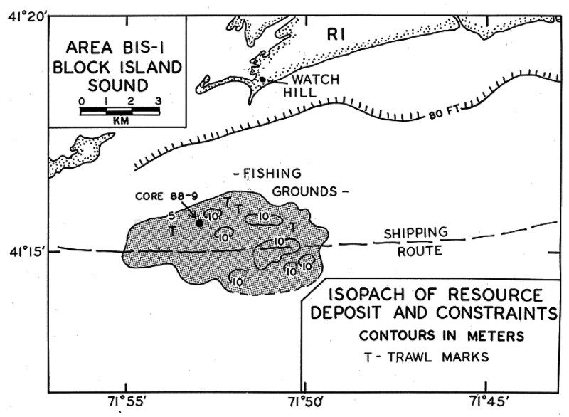
Based on core 88-9, resource area BIS-1 was found to be marked by medium to coarse sand and heavy minerals in concentrations of approximately 4%. Medium to coarse sand and pebbles were found to characterize resource area BIS-2 (sites 88-10 and 88-11). Concentrations of heavy minerals were found to be less than 3%.
In Rhode Island Sound, resource area RIS-1 was vibra-cored at site 88-12 in order to gain information about three seismic units of undetermined texture and origin. The core was found to consist of clayey silt of inferred Holocene fluvial, estuarine, and marine origins. Inferred surficial Pleistocene glacial deposits were the intended targets in resource area RIS-2 at sites 88-13 and 88-14. Inferred marine sand overlying estuarine silt characterizes core 88-13. An inferred, reworked glacial outwash environment or marine sand marks core 88-14. Heavy minerals were found in concentrations of 0.3 - 1.6 %.
INTRODUCTION
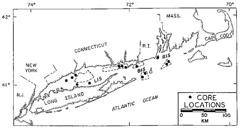
 As part of a comprehensive effort to assess the occurrence, extent, and availability of non-energy resources, vibra-cores were collected from Long Island, Block Island, and Rhode Island Sounds
(Figure 1). This work constitutes the investigation required of the fourth year of the multi-year study plan that was developed to quantify and evaluate the resource potential of the offshore areas of Connecticut and Rhode Island (Friedrich and others, 1986). Cores were collected from those areas identified in the first year resource assessment as areas offering potential for exploitation in regions of least user conflict. Seismic reflection and side-scan profiling were carried out in these areas during the second (FY 1985) and third (FY 1986) years of the study plan (Neff and others, 1987 and 1988). The selection of coring targets was made based on the analysis of these profile data. In Long Island Sound, inferred Pleistocene glacial outwash deposits were the intended core targets at sites 88-1,88-3, 88-4, 88-7, and 88-8
(Figures 2a,
2b, and 2c). Site 88-2 was selected to penetrate a seismic stratigraphic unit of unknown origin. A potential placer deposit, in the form of a relict shoreline feature, was the intended target at site 88-5, and a surficial resource deposit, previously inferred to be a coarse-grained lag deposit (Neff and others, 1987 and 1988), was the intended target at site 88-6. Coring sites in Block Island Sound were selected in order to sample inferred Holocene marine deposits (sites 88-9, 88-10, and 88-11)
(Figure 3). In Rhode Island Sound, site 88-12 was attempted in order to penetrate three seismic stratigraphic units of undetermined origin
(Figure 4a). Inferred surficial Pleistocene glacial deposits were the intended targets at 88-13 and 88-14
(Figure 4b). As part of a comprehensive effort to assess the occurrence, extent, and availability of non-energy resources, vibra-cores were collected from Long Island, Block Island, and Rhode Island Sounds
(Figure 1). This work constitutes the investigation required of the fourth year of the multi-year study plan that was developed to quantify and evaluate the resource potential of the offshore areas of Connecticut and Rhode Island (Friedrich and others, 1986). Cores were collected from those areas identified in the first year resource assessment as areas offering potential for exploitation in regions of least user conflict. Seismic reflection and side-scan profiling were carried out in these areas during the second (FY 1985) and third (FY 1986) years of the study plan (Neff and others, 1987 and 1988). The selection of coring targets was made based on the analysis of these profile data. In Long Island Sound, inferred Pleistocene glacial outwash deposits were the intended core targets at sites 88-1,88-3, 88-4, 88-7, and 88-8
(Figures 2a,
2b, and 2c). Site 88-2 was selected to penetrate a seismic stratigraphic unit of unknown origin. A potential placer deposit, in the form of a relict shoreline feature, was the intended target at site 88-5, and a surficial resource deposit, previously inferred to be a coarse-grained lag deposit (Neff and others, 1987 and 1988), was the intended target at site 88-6. Coring sites in Block Island Sound were selected in order to sample inferred Holocene marine deposits (sites 88-9, 88-10, and 88-11)
(Figure 3). In Rhode Island Sound, site 88-12 was attempted in order to penetrate three seismic stratigraphic units of undetermined origin
(Figure 4a). Inferred surficial Pleistocene glacial deposits were the intended targets at 88-13 and 88-14
(Figure 4b).
PROCEDURES
Field Operation
Previously examined seismic and side-scan data (Neff and others, 1987 and 1988) were used to select vibra-core sites. Coring targets were designed to sample surficial and shallow subbottom resource deposits. As part of the Minerals Management Service, New England Coastal States Co-operative Program, vibra-coring of fourteen sites was carried out aboard the R/V Atlantic Twin (Alpine Ocean Seismic Survey, Inc.) in September, 1988. Allowing a maximum penetration of 30 feet, an Alpine vibra-coring system was used, and navigation was accomplished by Loran C positioning. An ORE Geopulse profiling system was used to obtain a seismic profile at each site. Seismic signals were filtered between 300 and 7000 Hz and recorded on an EPC Model 4800 graphic recorder at 1/4 second sweep.
Core Processing
The fourteen cores from Connecticut and Rhode Island coastal waters were cut into 5-foot sections and transported to the U.S. Geological Survey, Woods Hole, Massachusetts. Cores were split longitudinally, photographed, and described visually. An archive half of each core was placed in storage at the core facility at the Woods Hole Oceanographic Institute. Subsamples for sediment analyses were taken from the working halves.
Based on visual descriptions and correlations with seismic data, depositional environmental interpretations were made.
Grain Size Analysis
A total of 21 pairs of 15-20 gram sediment samples was taken from cores 88-1,88-3, 88-4, 88-8, 88-9, 88-10, 88-11,88-13, and 88-14. One of each pair of samples was analyzed for grain size. Material greater than 2.00 mm (-1.0 phi) was removed with a 2.00 mm screen. The sand fraction was dry sieved (1/2 phi size screen interval) for 5 minutes using a Ro-Tap machine. Cumulative weight percents of each size fraction were used to calculate graphic mean grain size and inclusive graphic standard deviation (Folk, 1974).
Mineralogical Analyses
The other pair of sediment samples was analyzed for heavy mineral content. Samples were washed and air-dried. The sand fraction was isolated and boiled for 5 minute in a 10% solution of oxalic acid to eliminate iron stains. Heavy and light mineral fractions were separated using bromoform (sp. gr. 2.85). Weight percents of heavy minerals were calculated for all samples. Samples exhibiting very high percentages (greater than 5%) were analyzed further. Magnetite was removed from the heavy mineral fraction with a magnet. A split of the remaining minerals was slide-mounted in "Lakeside."
Heavy mineral species were identified under a petrographic microscope. The relative proportions of the different detrital minerals were determined by carefully counting spaced fields of grains. A minimum of 300 grains was recorded for each count.
In compiling the frequencies of the heavy mineral assemblage, group names (i.e. amphibole, epidote, garnet and tourmaline) are used to simplify tabulation. The term "opaques" includes metallic minerals of black and dark brown color with the exception of magnetite.
Analysis of Diatom Floras
Samples were collected from fine-grained units of cores 88-12, 88-13, and 88-14 (Rhode Island Sound). Samples were washed, diluted in distilled water, and allowed to settle. Smear slides were prepared from the settled material and examined microscopically.
RESULTS
Vibra-coring attempts were successful in collecting samples from fourteen sites
(Table 1). However, due to failure of the vibrator head, a core sample of only 1.55 m was obtained from site 88-2 (Long Island Sound). At site 88-10 (Block Island Sound), strong tidal currents repeatedly overturned the corer and a sample of only 0.56 m in length was secured. Elsewhere, recovered core lengths less that the potential maximum (30 feet) were the result of 1) loss of sediment through the core catcher during recovery and/or 2) limitations on penetration due to highly compacted sediment.
Core Descriptions
 Long Island Sound. Inferred Pleistocene glacial outwash deposits, associated with the Lordship Moraine, was the intended target at site 88-1
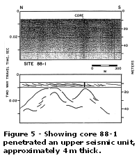
(Figure 2a). The core, 4.64 m in length, consists of predominantly yellowish brown, moderately-well sorted, fine sand
(Table 2 and 88-1
Description). The top section (0 - 88 cm) is marked by gray, silty sand with shells. A sharp, horizontal contact is noted at 424 cm, denoting color and texture changes. The bottom section (424-464 cm) consists of coarse sand, gravel, and pebbles.
Figure 5 indicates that the core penetrated an upper seismic unit, approximately 4 m thick, marked by an oblique progradational reflector pattern. This stratified unit rests on a high amplitude, continuous reflector which separates it from a lower unit of more complex seismic character. Core 88-1 also may have penetrated this prominent reflector. Long Island Sound. Inferred Pleistocene glacial outwash deposits, associated with the Lordship Moraine, was the intended target at site 88-1
(Figure 2a). The core, 4.64 m in length, consists of predominantly yellowish brown, moderately-well sorted, fine sand
(Table 2 and 88-1
Description). The top section (0 - 88 cm) is marked by gray, silty sand with shells. A sharp, horizontal contact is noted at 424 cm, denoting color and texture changes. The bottom section (424-464 cm) consists of coarse sand, gravel, and pebbles.
Figure 5 indicates that the core penetrated an upper seismic unit, approximately 4 m thick, marked by an oblique progradational reflector pattern. This stratified unit rests on a high amplitude, continuous reflector which separates it from a lower unit of more complex seismic character. Core 88-1 also may have penetrated this prominent reflector.
Core 88-2 consists of 1.55 m of gray sandy silt (88-2
Description). The vibrator head failed during the attempt at this site. Consequently, only the surficial seismic unit was sampled, not the underlying target unit marked by chaotic reflectors
(Figure 6). This core was not
subsampled.
The intended target at site 88-3 was inferred Pleistocene glacial outwash deposits, associated with the Southport Delta
(Figure 2a). The 4.17 m core is composed of predominantly gray-brown, moderately-well sorted, medium sand
(Table 2 and 88-3
Description). The top section (0-68 cm) consists of dark olive sandy silt to silty sand with shell fragments. Gravel, pebbles, and clasts up to 2 cm are noted throughout the remainder of the core. The bottom section (361-417 cm) is marked by parallel laminae. The seismic line at site 88-3 exhibits a laminated (-) facies overlying a diffractive, pseudo-clinoform to chaotic facies
(Figure 7). The width of the bottom pulse, approximately equal to the length of the core, masks the internal reflectors in the upper part of the deposit. Therefore, penetration of the core into the lower of these two facies is uncertain.
Inferred glacial outwash deposits, again associated with the Lordship Moraine, and an overlying inferred relict shoreline feature were the targets at site 88-4
(Figure 2a). The sample measures 6.44 m in length and consists of approximately 2 m of dark olive gray silt overlying 4 m of gray, moderately-well sorted medium sand
(Table 2 and 88-4
Description). A sharp, horizontal contact occurs at 218 cm. The top section (0-24 cm), consists of silt with whole shells. Sediment observed to be of similar color and texture was lost from 24-83 cm due to the fracture of a joint in the core liner during recovery. Coarser sediments, frequently occurring in distinct layers, are noted in the underlying sand sections. In addition, parallel laminae are observed from 510-630 cm. Three seismic facies appear to have been penetrated by vibra-core 88-4: 1) a well-laminated unit, 2 m thick, marked by high amplitude, parallel, flat-lying reflectors, 2) another laminated unit, 2 m thick, bounded by angular unconformities, and 3) a thick facies exhibiting a chaotic reflector pattern
(Figure 8).
A potential placer deposit, in the form of a relict shoreline feature, was the target at site 88-5
(Figure 2b). The core, 2.88 m in length, consists of a top section (0-165 cm) of olive gray, sandy silt; a middle section (165-175 cm) of brown, medium sand; and a bottom section (175-288 cm) of dark gray, medium sand
(88-5 Description). A sharp, inclined contact is observed at 165 cm. Grain size samples were collected and analyzed by P. Gayes of the University of South Carolina. The seismic record from which this target was selected as well as the Geopulse record made on site during the coring attempt are of quality too poor to reproduce.
Core 88-6 was intended to sample a coarse-grained lag deposit previously inferred to characterize resource area LIS-3
(Figure 2c). The sample, 6.18 m long, consists of gray to red, sandy silt with abundant organic material
(88-6 Description).
Figure 9 indicates that the core penetrated the target unit, a highly reflective, chaotic to diffuse facies approximately 5 m thick. The core also appears to have penetrated an underlying, irregular unconformity although no distinct contact was observed. Due to the fine-grained nature of this sample, no subsamples were collected.
Inferred glacial outwash sediments were the intended targets at sites 88-7 (Niantic River Delta) and 88-8 (Thames River Delta) also located within resource area LIS-3
(Figure 2c). Core 88-7, 5.13 m long, consists of dark olive gray, sandy silt and clay with shell fragments (0-478 cm) overlying mottled silt and sand (478-513 cm)
(88-7 Description). A sharp, irregular contact separates these two units at 478 cm. The seismic line at this site indicates that core 88-7 penetrated a well-laminated facies, approximately 4.5 m thick, and an underlying, pseudo-clinoform to chaotic facies
(Figure 10). Due to the fine-grained texture of this core, no subsamples were collected.
Core 88-8, 7.63 m long, consists of predominantly moderately-well sorted fine sand of varying color (gray, olive, brown, yellow) occurring in folded and contorted laminations of, generally, less that 1 cm thickness
(Table 2 and 88-8
Description). Red clay inclusions are noted throughout and sharp contacts occur at 171 cm, 216 cm, 307 cm, and 433 cm.
Figure 11 indicates that vibra-core 88-8 penetrated two seismic facies separated by a prominant unconformity. The upper unit, approximately 4 m thick, exhibits both parallel, flat-lying and oblique, progradational reflectors. The lower facies, of greater thickness, is more complex with laminations (irregular and flat-lying), chaotic reflectors, and cut-and-fill structures.
Block Island Sound. Vibra-coring targets in Block Island Sound, at sites 88-9, 88-10, and 88-11, were selected in order to sample inferred, surficial, Holocene marine deposits
(Figure 3). Core 88-9 was collected from resource area BIS-1 and consists of 2.91 m of gray to gray-brown, moderately sorted, medium to coarse sand
(Table 2 and 88-9
Description). Worthy of note, the 100 cm (downcore depth) grain size sample contained 8.4% gravel (greater than 2.00 mm). The seismic line at this site indicates that the core penetrated the surficial facies, a laminated unit exhibiting a convex-up configuration
(Figure 12). This unit rests on a prominent unconformity, approximately 4 m below the seafloor, which apparently was not penetrated by the core.
At site 88-10, resource area BIS-2, strong, tidal currents repeatedly overturned the corer and a sample of only 0.56 m in length was collected. The sample consists of very coarse sand and pebbles
(Table 2 and 88-10
Description). Grain size analyses reveal that 34.4% of the sample is greater than 2.00 mm (gravel). At the time of core recovery, live mussels were noted attached to the larger clasts at the surface (top) of the sample. The seismic line at site 88-10 is of very poor quality
(Figure 13). The width of the bottom pulse masks the internal character of the sampled facies.
Site 88-11 is also located within resource area BIS-2. The vibra-core from this site measures 3.92 m in length and consists of well to very well sorted, medium-grained, yellow sand
(Table 2 and 88-11
Description). The seismic character of the target facies is somewhat obscured by the effects of the bottom pulse
(Figure 14). However, as previously described by Neff and others (1987), this unit exhibits low-amplitude, oblique, landward- and seaward-dipping parallel reflectors. Asymmetric bedforms are also noted.
Rhode Island Sound. The objective in sampling site 88-12 (resource area RIS-1;
Figure 4a) was to gain information about three seismic units of undetermined texture and origin. The vibra-core, 4.58 m in length, consists of predominantly dark olive gray, claying silt
(88-12 Description). The upper section, 0-375 cm, is marked by shell fragments. Increased sand content and black organic material characterize the lower section (375-458 cm). Also worthy of note are the pebbles and gravel observed within the bottom 10 cm of the core and in the core cutter.
Figure 15 indicates that the core sampled only the upper two seismic facies, and likely failed to penetrate the third unit of interest. These upper two facies are separated by an unconformity at approximately 3.75 m below the seafloor. Neff and others (1988) described both units as laminated.
Inferred surficial Pleistocene glacial drift deposits were the intended targets at sites 88-13 and 88-14 (resource area RIS-2;
Figure 4b). Vibra-core 88-13 measures 5.14 m in length and consists of approximately 3 m of gray-brown, medium to fine sand overlying 2 m of dark gray silt and clay
(Table 2 and 88-13
Description). A sharp contact is visible at 303 cm. The seismic character of this site is largely chaotic
(Figure 16). A low-amplitude, discontinuous, irregular unconformity is noted at the site approximately 3.0 - 3.5 m below the sea floor. The core appears to have penetrated this unconformity.
At site 88-14, the core is characterized by 360 cm of moderately to well sorted, yellowish brown, medium to fine sand overlying approximately 20 cm of gray, fine sand and silt
(Table 2 and 88-14
Description). Total core length is 3.79 m. Sandy gravel and a large 7 cm clast are noted in the top section, 0-47 cm. The seismic line at 88-14 reveals predominantly high-amplitude, chaotic reflectors
(Figure 17). Zones of parallel, wavy to flat-lying reflectors are interspersed throughout the chaotic areas. The character change is gradational. The effects of the bottom pulse obscure the internal character of the near-bottom. However, the core appears to have penetrated both a chaotic zone (approximately 3 m thick), and an underlying laminated zone. The presence of an unconformity between these two zones of differing seismic character is uncertain.
Heavy Mineral Content
Results of the heavy mineral analyses are presented in Tables 3a and 3b. Weight percentages of heavy minerals range from 0.3% to 9.0%. The lowest values, less that 2%, are found in samples from Rhode Island Sound (88-13 and 88-14). In Block Island Sound, at sites 88-10 and 88-11, values of less than 3% are found. Two samples from core 88-9, resource area BIS-1 in northern Block Island Sound, yield weight percents of heavy minerals between 3% and 5%. The greatest values, up to 9.0%, are found in cores from Long Island Sound.
The one sample from each of the Long Island Sound cores yielding the greatest concentration of heavy minerals was examined to determine mineral composition
(Table 3b). Magnetite comprises less than 1% of the heavy mineral fraction in samples from cores 88-1,88-3, 88-4, and 88-8. The most abundant minerals counted were amphibole, garnet, and
opaques.
Diatom Floras
Fine-grained units of cores 88-12, 88-13, and 88-14 (Rhode Island Sound) were examined cursorily for diatom content. Marine planktonic forms, representative of an open water marine environment, were found in the 10 cm and 180 cm samples of core 88-12
(Table 4). Paralla sulcata was observed to be most abundant. Marine to brackish benthic forms were noted downcore in the 420 cm sample. This assemblage, including DipIoneis smithii and Rhabdonema adriaticum, represent a shallow water estuarine environment. The 453 cm sample was devoid of diatoms. In addition, no forms were found in either 88-13 or 88-14.
DISCUSSION
Long Island Sound
In Long Island Sound, inferred Pleistocene glacial outwash deposits were the intended core targets at sites 88-1,88-3, 88-4, 88-7, and 88-8
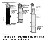
(Figures 2a and 2c). Cores 88-1 and 88-4 were collected from offshore the Stratford-Lordship area of the Connecticut shore. Onshore outwash deposits in this region have been described by Flint (1968) as consisting of lenticular beds, marked by parallel laminae and a relatively small range of grain sizes (sand to pebbles). Such deposits are believed to be contained in core 88-1, from 88-424 cm, and in core 88-4, from 480-644 cm
(Figure 18, and Explanation). Core 88-4 may also contain a relict shoreline feature, from 218-480 cm, as inferred from seismic data
(Figure 8). However, neither the grain size nor the heavy mineral data (Tables 2 and 3a) substantiate this assumption. The gravel and pebbles in the bottom section of core 88-1,424-464 cm, are inferred glacial drift deposits, possibly derived from the Lordship Moraine.
Coring attempts at site 88-3 also appear to have been successful in sampling glacial outwash delta deposits
(Figure 18). Underlying a fine-grained, Holocene, estuarine to marine unit (0-68 cm), inferred outwash deposits exhibit characteristics similar to those in the Lordship area: well sorted, medium grain size, some scattered pebbles, and laminations in the lower sections.
 Previous assumptions made regarding the stratigraphy at site 88-7 were disproved by core 88-7. Seismic data suggested that glacial outwash delta deposits existed at this site under 4-5 m of Holocene marine sediments. The Holocene section was found to consist of silt and clay, and is inferred to represent estuarine to low-energy marine environments
(Figure 19 and Explanation). The underlying section, marked on the seismic record by pseudo-clinoform to chaotic reflectors, was finer-grained than anticipated. The depositional environment of the mottled silt and sand, from 478-513 cm, is uncertain. Possible interpretations include estuarine or upper delta deposits. Previous assumptions made regarding the stratigraphy at site 88-7 were disproved by core 88-7. Seismic data suggested that glacial outwash delta deposits existed at this site under 4-5 m of Holocene marine sediments. The Holocene section was found to consist of silt and clay, and is inferred to represent estuarine to low-energy marine environments
(Figure 19 and Explanation). The underlying section, marked on the seismic record by pseudo-clinoform to chaotic reflectors, was finer-grained than anticipated. The depositional environment of the mottled silt and sand, from 478-513 cm, is uncertain. Possible interpretations include estuarine or upper delta deposits.
The inferred outwash delta deposits of core 88-8 are finer-grained than those collected from sites previously discussed. The predominant grain size is fine sand, occurring in horizontal to folded and contorted laminations of differing color. The top section, 0-171 cm, is an inferred Holocene estuarine to low-energy marine unit
(Figure 19). Heavy mineral analyses indicate that these glacial outwash deposits, cored at sites 88-1, 88-3, 88-4, and 88-8, contain high concentrations (6-9%) of heavy minerals, especially amphibole and garnet
(Table 3b).
As previously discussed, equipment failure at site 88-2 resulted in a sampling of only the surficial seismic facies at this site. This unit of sandy silt is interpreted to be of Holocene estuarine to marine origin. A similar interpretation is given to the top section (0-165 cm) of core 88-5
(Figure 19). The underlying sections (165-288 cm) are deposits of an inferred relict shoreline feature. The grain size information supports the interpretation of a general deepening of water at the site (P. Gayes, written communication). However, a definitive interpretation is difficult in the absence of a good quality seismic record at this site.
Core 88-6 was intended to sample a coarse-grained lag deposit previously inferred to characterize resouce area LIS-3
(Figure 2c). However, this previous assumption made from seismic data regarding the stratigraphy and sediment texture were not substantiated by core 88-6. The sample consists of sandy silt with abundant organic material. Coarse sand and pebbles occur only in the bottom of the core (550-618 cm). This material is inferred to represent a deepening of water from a fluvial environment through estuarine and marine environments
(Figure 19). The coarse material below 550 cm may be of fluvial origin or may represent a penetration of the unconformity into underlying glacial drift deposits.
Block Island Sound
Vibra-coring targets in Block Island Sound, at sites 88-9, 88-10, and 88-11, were selected in order to sample surficial facies of inferred Holocene marine deposits
(Figure 3).
Based on side scan data, Neff and others (1988) inferred that the surficial sediments of resource area BIS-1 consisted of gravel. The texture of core 88-9 was found to be medium- to coarse-grained sand with lesser amounts of gravel. Shell fragments throughout the core suggest that the sample is of marine origin
(Figure 20 and Explanation). The concentrations of heavy minerals in this core,, approximately 4%
(Table 3a), are consistent with those reported by Savard (1966) and summarized by Friedrich and others (1986). Therefore, mineral composition is assumed to be similar with amphibole, garnet, and black opaques dominating.
Although core 88-10 is of limited length (0.56 m) and the associated seismic line reveals little stratigraphy, the texture of the sample substantiates previous interpretations. Neff and others (1988) inferred from side scan sonographs that the surficial sediments of the western portion of area BIS-2 consisted of megarippled sand and gravel. These Holocene marine deposits are derived from reworked glacial drift
(Figure 20).
Sand and gravel were also reported to dominate at the surface within BIS-2 in proximity to site 88-11 (Neff and others, 1988). As indicated by the grain size analyses
(Table 2), the Holocene marine sediments at this site consist of very well sorted medium sand. This is consistent with the interpretation that these sediments comprise a relict (early Holocene) flood tidal delta (Neff and others 1987)
(Figure 20). Heavy minerals at 88-10 and 88-11, found in concentrations of less than 3%
(Table 3a), are presumed to be similar in composition to those reported by Savard (1966). Black opaques, amphibole, and garnet are the three primary constituents of a sample located less than 2 km from site 88-11.
Rhode Island Sound
In resource area RIS-1, site 88-12 was vibra-cored in order to gain information about three seismic units of undetermined texture and origin
(Figure 4a). The seismic section at this site, presented in
Figure 15, was described by Neff and others (1988). Unit 2 was described as a channel-fill facies of late Pleistocene to early Holocene age. The overlying unit 3 was inferred to be of fluvial and/or estuarine origin, while unit 4 (at the sea-floor surface) was reported to consist of inferred Holocene marine deposits. In that only one contact is observed in core 88-12, at 375 cm, the penetration of only units 4 and 3 is presumed. The results of the grain size analysis
(Table 2) and examination of diatom floras
(Table 4) affirm the previous interpretations. The top section (0-375 cm) is inferred to represent a low-energy, Holocene marine environment due to the fine grain size, and the presence of marine fauna and open-water, marine diatoms
(Figure 21 and Explanation). The underlying section (375-458 cm) is interpreted to consist of estuarine sediments. The absence of diatoms at 453 cm and the presence of gravel and pebbles from 450-458 cm (and in the core cutter) suggest that the contact between early Holocene estuarine and fluvial environments occurs at or near this downcore depth. It is, therefore, inferred that the underlying unit observed seismically (unit 2;
Figure 15) is a coarse-grained, post-glacial unit of fluvial sediments.
Inferred Pleistocene glacial drift deposits were the intended targets in resource area RIS-2, sites 88-13 and 88-14
(Figure 4b). Surficial drift deposits of glacial till, recessional (terminal) moraine, and outwash deposits have been mapped by Needell and others (1983) and Neff and others (1988). Texturally, these deposits have been reported to consist of sand, gravel, pebbles, and scattered boulders (Knebel and others, 1982; Neff and others, 1988). The dominant seismic facies, characterized by chaotic reflectors, was vibra-cored at site 88-13. The upper 3 m of medium to fine sand with scattered gravel clasts is inferred to be of marine origin due to the presence of a few scattered shell fragments
(Figure 21). These sediments are presumed to be shelf deposits derived from the reworking of glacial drift. A sharp contact at 303 cm, which correlates with an irregular unconformity at approximately the same depth in
Figure 16, separates these marine deposits from an underlying unit of silt and clay. The depositional history of this unit is uncertain due, in part, to the lack of sedimentary structures, and the absence of marine fauna and diatom floras. Needell and others (1983) inferred from seismic data the presence of glaciolacustrine deposits in this area. However, samples of glacial lake deposits from Block Island and Long Island Sounds exhibit distinct varves (Bertoni and others, 1977; Needell and Lewis, 1984; and Lewis and Needell, 1987). No such structures are observed in this unit of core 88-13. Examination of diatoms yielded no evidence to support either freshwater or marine deposition. The stratigraphic position of this unit (underlying marine sand) and the occurrence of mottling due to the presence of organic matter suggest that the unit may consist of estuarine deposits.
The target at site 88-14 is characterized by zones of parallel, wavy to flat-lying reflectors interspersed throughout areas of chaotic reflectors
(Figure 17). The top 46 cm of medium sand in core 88-14 is inferred to be of marine origin due to the presence of a few shell fragments
(Figure 21). The underlying 3 m of medium to fine sand may also consist of reworked glacial drift deposited in a marine environment. However, other than the grain size data, there is little evidence to support this assumption. An alternative interpretation is that of glacial outwash. Site 88-14 is located on the northern flank of a relict drainage system
(Figure 4b) which may have been active during the last ice retreat. The sedimentary structures found in the core, including laminae of organic material, are similar to those found in outwash deposits in Long Island Sound.
The contact at 360 cm between yellowish brown fine sand and a gray silty unit correlates roughly with the top of the laminated zone on the seismic line
(Figure 17). This laminated zone may be of either fluvial, or estuarine origin. Heavy minerals were found in very low concentrations at these sites (less than 2%,
Table 3a). McMaster (1962) reported similar concentrations at sites in proximity to 88-13 and 88-14. Black opaques, rock fragments, and "other" minerals were the dominant groups.
NON-ENERGY RESOURCES
Long Island Sound
The presence of extensive glacial outwash delta deposits in Long Island Sound has been previously reported (Neff and others, 1987 and 1988). These deposits comprise a significant source of aggregate material, primarily sand and heavy minerals (predominantly amphibole and garnet). However, "overburden" units of fine-grained Holocene fluvial, estuarine, and/or marine sediments commonly restrict the accessibility of this resource. Fine-grained units overlying inferred outwash deposits of potential resource material are observed in cores 88-1,88-3, 88-4, and 88-8. As characterized by sites 88-1 and 88-4, the Lordship Delta is up to 20 m thick but is overlain by 88-218 cm of silt
(Figures 5, 8, and
18). Based on an average thickness of 10 m over an area of 50 km2 (area derived from bathymetric contours), the Lordship Delta may yield 500 million m3 of sediment suitable for aggregate. The most significant constraint to exoloitation is the proximity of the resource deposits to the shoreline. Much of the Delta occurs in depths shallower than 40 feet, an area maintained as a shellfish preservation zone
(Figure 2a). The Southport Delta also appears to be up to 20 m thick, at site 88-3, but is overlain by 68 cm of silt
(Figures 7 and 18). An estimate of the area of this delta is not available; therefore, a volumetric assessment of the potential resource cannot be determined. Inactive dredge disposal sites are noted in the general area
(Figure 2a).
Outwash delta deposits south of the Thames River (site 88-8) have also been confirmed, by coring, as consisting of potential resource materials (sand and heavy minerals). The overburden unit at this site was previously described by Neff and others (1988) as Holocene marine sand (unit 4a), a product of tidal current reworking of glacial drift suitable as aggregate. The core revealed that the upper 171 cm consists of silt which acts as a constraint to the accessibility of the underlying units and is not suitable as aggregate. Elsewhere in this region (resource area LIS-3), at sites 88-6 and 88-7, units previously inferred to be suitable resources were found to be too fine-grained. The previously reported estimate of 200 million m3 of sand and gravel in area LIS-3, although a conservative figure based on a 5 m thickness over 40 km2 , is consequently reduced to at least 160 million m3 (40 km2 by 4 m thickness). In addition to the overburden, constraints and/or conflicts in this area include a ferry route, cable areas, and a dredge disposal site
(Figure 2c).
The inferred relict shoreline feature consisting of medium sand at site 88-5 also offers potential as resource material. The overburden at this site is 165 cm thick
(Figure 19). Although less than 5 m thick, this beach feature has been mapped over a distance of 20 km along the south shore of Long Island Sound (Gayes, 1987) and may extend much farther. The general area appears free of constraints
(Figure 2b).
In Long Island Sound, heavy minerals from glacial outwash delta deposits are found in concentrations offering economic potential (up to 9.0%). However, abundances of titanium-bearing minerals (ilmenite and rutile) and rare-earth minerals (monazite and zircon) are low.
Block Island Sound
In northern Block Island Sound (area BIS-1), Neff and others (1987) identified a potential resource deposit inferred to consist of Holocene marine sand with patches of gravelly sand. From seismic data, this deposit was determined to be approximately 200 million m3 in volume. Side scan observations had suggested that the surface of the deposit
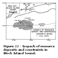 was composed of gravel (Neff and others, 1988). Core 88-9 reveals that the deposit consists of medium to coarse sand with shell fragments. The size of this material and the heavy mineral concentrations of approximately 4% confirm that the deposit offers potential as a resource. Fishing activities constitute the primary constraint on exploitation in area BIS-1
(Figure 22). was composed of gravel (Neff and others, 1988). Core 88-9 reveals that the deposit consists of medium to coarse sand with shell fragments. The size of this material and the heavy mineral concentrations of approximately 4% confirm that the deposit offers potential as a resource. Fishing activities constitute the primary constraint on exploitation in area BIS-1
(Figure 22).
In southern Block Island Sound (area BIS-2), Neff and others (1987) identified approximately 2.5 billion m3 of coarse-grained Holocene sediments as potentially suitable for resource exploitation. Sidescan sonographs indicated that these sediments consisted of patchy sand and gravel with the frequent occurrence of bedforms (Neff and others, 1988). These assessments appear to be substantiated by vibra-coring results at sites 88-10 and 88-11. However, these deposits appear to offer limited potential as a source of heavy minerals. Fishing activities and potentially inhospitable tidal current velocities (2 kt) constitute constraints in area BIS-2
(Figure 23).
Rhode Island Sound
Neff and others (1987 and 1988) reported that Pleistocene glacial drift consisting of till, moraine, and outwash deposits was the dominant seismic facies in Rhode Island Sound. An estimate of 80 million m3 of glacial drift was determined to exhibit a seafloor exposure in resource area RIS-I. The results of vibra-coring at site 88-12 do not increase this estimate. Fine-grained, post Pleistocene depositional environments offering no resource potential were sampled by this core.
In resource area RIS-2, Neff and others (1988) estimated that coarse-grained glacial drift was an average 30 m thich over 135 km2, yielding 4 billion m3 of potential resource material. Vibra-cores 88-13 and 88-14. reveal that the dominant seismic facies, marked by chaotic reflectors, does not consist of a uniform depositional environment. Fine-grained units (silt and clay) occur under 3-4 m of sand. The thickness estimate of 30 m is not confirmed. The volumetric assessment of potential resource deposits in area RIS-2 is reduced to 400 million m3.
The resources mapped in Rhode Island Sound coincide, in part, with established shipping lanes
(Figure 24). Documented fishing grounds and a cable route are found along the margins of the area. Of these constraints, fishing activities, which are not limited to the documented regions, pose the .qreatest conflict to resource exploitation.
SUMMARY
Inferred Pleistocene glacial outwash delta deposits, identified from sesimic data, were the intended core targets at sites 88-1,88-3, 88-4, 88-7, afnd 88-8 in Long Island Sound. Outwash deposits of fine to coarse sand were identified at all these sites with the exception of 88-7. Mottled silt and sand, representative of an upper delta or estuarine environment, were found in 88-7. Fine-grained Holocene estuarine to low-energy marine deposits, up to a few meters thick, were found overlying outwash deposits. Elsewhere in Long Island Sound, equipment failure at site 88-2 resulted in a sampling of only the surficial facies of Holocene estuarine to marine sediments. An inferred relict shoreline feature of medium sand also overlain by a fine-grained Holocene unit, was sampled at site 88-5. Core 88-6 was intended to sample a coarse-grained lag deposit previously inferred to characterize resource area LIS-3. This previous assumption made from seismic data regarding the stratigraphy and texture was not substantiated by the core. The sample was found to consist of sandy silt with abundant organic material.
Vibra-coring targets in Block Island Sound were selected in order to sample surficial facies of inferred Holocene marine deposits. Previously collected side scan data suggested that surface sediments in resource area BIS-1 (northern Block Island Sound) consisted of gravel. The texture of core 88-9 was found to be medium- to coarse-grained sand with lesser amounts of gravel. Shell fragments throughout the sample confirm the Holocene marine origin. Side scan sonographs also suggested that the western portion of resource area BIS-2 (southern Block Island Sound) consisted of megarippled sand and gravel. The texture of the sample at site 88-10 substantiated previous interpretations. The core was found to contain very coarse sand and pebbles. Sand and gravel were previously reported to dominate at site 88-11 (BIS-2). The core yielded a sample of very well-sorted medium sand. This is consistent with the interpretation that these sediments comprise an early Holocene flood tidal delta.
In Rhode Island Sound, resource area RIS-1, site 88-12 was vibra-cored to gain information about three seismic units of undetermined origin. The core is inferred to consist of fine-grained Holocene fluvial, estuarine, and marine sediments. Inferred Pleistocene glacial drift deposits were the intended targets in resource area RIS-2, sites 88-13 and 88-14. The cores from these sites do not correlate well with the seismic data. In core ~38-13, 3 m of inferred Holocene marine sand overlies 2 m of silt and clay, of a presumed estuarine origin. Seismically, the site is largely chaotic. Site 88-14 is characterized by zones of parallel wavy to flat-lying reflectors. The top 46 cm of the core is a medium sand, inferred to be a marine deposit. This unit overlies 3 m of medium-to fine-grained, reworked glacial drift deposited in either a marine or glacial outwash environment. The bottom section consists of fine sand and silt and possibly represents a zone of parallel reflectors.
Weight percentages of heavy minerals range from 0.3-9.0%. Values of less than 2% are found in samples from Rhode Island Sound. In Block Island Sound, values of less than 3% are found. Two samples from resource area BIS-1 yield weight percents between 3% and 5%. The greatest values, up to 9.0%, are found in samples from Long Island Sound. These samples were found to be composed primarily of amphibole and garnet.
As characterized by sites 88-1 and 88-4, and based on an average thickness of 10 m, glacial outwash deposits of the Lordship Delta may yield 500 million m3 of sediment suitable as aggregate. "Overburden" units of fine-grained Holocene sediments act as a constraint on exploitation of these glacial deposits. Glacial outwash deposits suitable as aggregate also characterize the Southport Delta (site 88-3). However, a volumetric assessment of the potential resource has not been determined. Based on the results of vibra-coring at sites 88-6, 88-7, and 88-8, the previously reported estimate of available aggregate in the form of glacial outwash in area LIS-3 has been reduced to 160 million m3. Holocene "overburden" remains the most significant constraint in this area. The inferred relict shoreline feature at site 88-5 also offers potential as resource material. Although less than 5 m thick, the feature extends a distance of at least 20 km along the south shore of Long Island Sound, and is free of
constaints.
The results of vibra-coring in resource area BIS-1 (northern Block Island Sound) indicate that the area is marked by approximately 200 million m3 of medium to coarse sand with heavy mineral concentrations of approximately 4%. Fishing activities constitute the primary constraint on exploitation in area BIS-I. Vibra-coring at sites 88-10 and 88-11 substantiated previous assessments regarding available aggregate in resource area BIS-2 (southern Block Island Sound). The area is characterized by approximately 2.5 billion m3 of medium- to coarse-grained Holocene sediments potentially suitable for exploitation. These deposits offer limited potential as a source of heavy minerals. Fishing activities and inhospitable tidal currents constitute constraints in the area.
In resource area RIS-1 (Rhode Island Sound), deposits represented by core 88-12 offer no resource potential. In resource area RIS-2 the previous volumetric estimate of suitable aggregate was based on the assumption that the glacial drift was an average 30 m thick. Vibra-cores 88-13 and 88-14 reveal that the chaotic seismic facies, from which the average thickness was determined, does not consist entirely of suitable sediment. The volumetric estimate is reduced to 400 million m3 of sand and gravel.
REFERENCES
Bertoni, R.S., J. Dowling, and I. Frankel, 1977, Freshwater-lake sediments beneath Block Island Sound. Geology, v. 5, p. 631-635.
Flint, R.F., 1968, The surficial geology of the Ansonia and Milford Quadrangles. Connecticut Geologic and Natural History Survey Quadrangle Report 23, 36 p.
Folk, R./., 1974, Petrology of Sedimentary Rocks. Austin, Texas, Hemphill, 182 p.
Friedrich, N.E., R.I_. McMaster, H.F. Thomas, and R.S. Lewis, 1986, Non-energy Resources Connecticut afnd Rhode Island Coastal Waters. Minerals Management Service Cooperative Agreement No. 14-12-0001-30115, Final Report FY 1984, 55 p.
Gayes, P.T., 1987, Buried paleoshorelines in Long Island Sound: Evidence for irregualrities in the post-glacial marine transgression in to Long Island Sound. Ph.D. dissertation, State University of New York at Stony Brook, Stony Brook, 196 p.
Lewis, R.S. and S.W. Needell, 1987, Maps showing the stratigraphic framework and Quaternary geologic history of eastern Long Island Sound. U.S. Geol. Survey Misc. Field Studies, map MF-1939-A (3 sheets and pamphlet).
McMaster, R.I_., 1962, Petrography and genesis of recent sediments in Narragansett Bay and Rhode Island Sound, Rhode Island. Jour. Sed. Petrol., v. 32, n. 3, p. 484-501.
Needell, S.W. and R.S. Lewis, 1984, Geology and structure of Block Island Sound, Rhode Island and New York. U.S. Geol. Survey Misc. Field Studies, Map MF-1621 (4 sheets).
Needell, S.W., C.J. O'Hara, and H.J. Knebel, 1983, Maps showing geology and shallow structure of western Rhode Island Sound, Rhode Island. U.S. Geol. Survey Misc. Field Studies, Map MF-1537 (4 sheets).
Neff, N.F., R.L. McMaster, R.S. Lewis, and H.F. Thomas, 1987, Non-energy resources, Connecticut and Rhode Island coastal waters. Minerals Management Service Cooperative
Agreement No. 14-12-0001-30296, Final Report FY 1985, 45 p.
Neff, N.F., R.L. McMaster, R.S. Lewis, and H.F. Thomas, 1988, Non-energy resources, Connecticut and Rhode Island coastal waters. Minerals Management Service Cooperative Agreement No. 14-12-0001-30316, Final Report FY86, 47 p.
Savard,W.L., 1966, The sediments of Block Island Sound, M.S. Thesis, Univ. of Rhode Island, Kingston, RI, 67 p.
LIST OF FIGURES
Figure
1. Location map of the study area and core locations
Figure
2a. Core locations, western Long Island Sound
Figure
2b. Core locations, central Long Island Sound
Figure
2c. Core locations, eastern Long Island Sound
Figure 3. Core locations, Block Island Sound
Figure
4a. Core locations, area RIS-1, Rhode Island Sound
Figure 4b. Core locations, area RIS-2, Rhode Island Sound
Figure 5. Seismic profile and schematic interpretation site 88-1
Figure 6. Seismic profile and schematic interpretation site 88-2
Figure 7. Seismic profile and schematic interpretation site 88-3
Figure 8. Seismic profile and schematic interpretation site 88-4
Figure 9. Seismic profile and schematic interpretation, site 88-6
Figure 10. Seismic profile and schematic interpretation site 88-7
Figure 11. Seismic profile and schematic interpretation site 88-8
Figure 12. Seismic profile and schematic interpretation site 88-9
Figure 13. Seismic profile and schematic interpretation site 88-10
Figure 14. Seismic profile and schematic interpretation, site 88-11
Figure 15. Seismic profile and schematic interpretation, site 88-12
Figure 16. Seismic profile and schematic interpretation, site 88-13
Figure 17. Seismic profile and schematic interpretation, site 88-14
Figure 18. Depositional environment interpretation, cores 88-1, 88-3, 88-4
Figure 19. Depositional environment interpretation, cores 88-5, 88-6, 88-7, 88-8
Figure 20. Depositional environment interpretation, cores 88-9, 88-10, 88-11
Figure 21. Depositional environment interpretation, cores 88-12, 88-13, 88-14
Figure 22. Map of potential non-energy resource deposits and constraints on resource development, area BIS-1, Block Island Sound
Figure 23. Map of potential non-energy resource deposits and constraints on resource development, area BIS-2, Block Island Sound
Figure 24. Map of potential non-energy resource deposits and constraints on resource development, area RIS-2, Rhode Island Sound
LIST OF TABLES
Table 1. Vibra-cores recovered during the R/V Atlantic Twin coring operation
Table 2. Vibra-core subsample locations and grain size analysis results
Table 3a. Weight percents of light and heavy minerals in
vibra-cores
Table 3b. Heavy mineral composition of selected vibra-cores from Long Island Sound
Table 4. Results of examination of diatom floras in sediment samples from Rhode Island Sound
vibra-cores
|