| OF
2005-1089
Disc Contents
Introduction
Surficial Geology
GIS/Visualization
Data Catalog
References Cited
Acknowledgments
Contacts
|
Surficial Geology of Pulley
Ridge
The southern part of Pulley Ridge has been imaged with high-resolution
seismic-reflection profiles, sidescan-sonar imagery, multibeam bathymetry,
bottom photographs and video of the seabed. These data have been
used to define the surficial and shallow subsurface geology of the area
(Jarrett and others, 2005). Seabed observations show deep-water coral
of the family Agariciidae, various algae, carbonate cobbles,
and localized outcrops of lithified beach rock (Halley and others, 2003;
Cross and others, 2004; Jarrett and others, 2005). The sidescan-sonar
imagery and multibeam bathymetry provide a regional context for the site
specific observations provided by the bottom photographs and video imagery.
Because of its depth (60-100 m), relatively few samples have been collected
from Pulley Ridge and the following interpretation is based entirely on
the remotely sensed data sets. These data have been incorporated into
the GIS within this publication, and this discussion is intended
to provide a preliminary overview of the geology of the area to aid users
with the data included in the GIS.
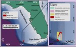
Figure 1. Location map. |
Pulley Ridge trends roughly north-south for almost 200 km along the western edge
of the southwestern part of the Florida Platform in 60-90 m water depths.
A second ridge in the southern part of Pulley Ridge, lies to the east in
58-78 m water depths (Fig. 1).
This ridge is the focus of this study because of the presence of hermatypic
corals covering its surface. The multibeam bathymetry shows that the ridge
trends north-northeast and resembles a barrier island, the top of which
is now submerged in
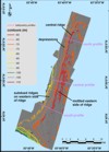
Figure 2. Shaded-relief bathymetry. |
58-65
m of water (Fig. 2). The ridge
is 4-7 km wide, approximately 34 km long and stands as much as 20 m above
the seafloor along its western side. A well-defined central ridge separates
the eastern from the western flank. In the northern part of the study
area the central ridge is less than 200 m wide and rises 2-8 m above the
adjacent flanks (Fig. 3). At the
southern end of the ridge, this central ridge becomes more subdued in
relief (1-4 m above the flanks) and bifurcates into several low ridges
that look much like recurved spits on a modern barrier
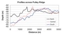
Figure 3. bathymetry profiles. |
beach.
The central ridge is 2000 m wide at this southern end. West of the central
ridge, several low-relief ridges that trend roughly parallel to the central
ridge characterize the seabed(Fig.
2). West, beyond these low-relief ridges, the seafloor is smooth with
the transition between the ridges and the surrounding seafloor marked
by a small step in 75-78 m water depth. Several sub-circular depressions
interrupt the ridges along the northern 8 km of the western side of the
ridge. These depressions are 30-200 m in diameter and as much as 3 m deeper
than the surrounding seafloor. The eastern side of Pulley Ridge has a
textured appearance on the shaded-relief image that results from a series
of discontinuous mounds and depressions. Short ridges with varying orientations
interrupt this textured pattern. The seafloor along the eastern edge of
the survey area, beyond the limits of the ridge, is 68-69 m deep.
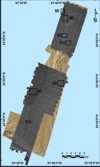
Figure 4. Sidescan sonar imagery. |
Eight different acoustic signatures were identified in the sidescan sonar imagery collected from the Pulley Ridge area. The sidescan image is quite uniform in its backscatter intensity, and it is only when a strong contrast enhancement is applied to the image that the backscatter differences become apparent (Fig. 4). For this analysis, intensity values between 80 and 140 were spread across the entire 8-bit range (0-255). The distribution of the different acoustic signatures is closely tied to the morphology of the ridge, and thus the signatures will be described relative to the ridge morphology (Fig. 5A).
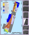
Figure 5. Geologic interpretation. |
The seafloor immediately surrounding Pulley Ridge has either a uniform, moderate-backscatter signature (mod-backscatter) or a low-backscatter signature with moderate intensity mottles on it (mottled-low). Areas having a moderate-backscatter signature fringe the southern and eastern sides of the ridge as well as the area northwest of the ridge (Fig. 5A, B). The low-backscatter signature with moderate intensity mottles on it (mottled-low) fringes the central part of the western side of the ridge and the northern end of the ridge (Fig. 5A, C). The moderate-backscatter signature area south of the southern end of Pulley Ridge extends to the upper continental slope. On the upper slope, alternating bands of high acoustic backscatter (high-backscatter) and low acoustic backscatter (low-backscatter) that trend parallel to the bathymetric contours characterize the seafloor (Fig. 5A).
Five different acoustic signatures characterize the surface of Pulley Ridge. Two of these acoustic signatures are found on the western side of the ridge. One is the broad lineation signature (broad lines) in the sidescan-sonar imagery (Fig. 5D), which coincides with low-relief linear ridges that show in the multibeam bathymetry (Fig. 2). These topographic features are best imaged by the sidescan in the northwestern part of the study area where these low-relief ridges are larger than they are elsewhere. A second acoustic signature that occurs only in the northwestern corner of the study area is characterized by 30-200 m sub-circular depressions that have low-backscatter floors (depressions-large; Fig. 5E).
The crest of Pulley Ridge is characterized by two acoustic signatures; a high-backscatter signature (high-backscatter) for much of its length (Fig. 5A), and alternating linear bands of low and very high backscatter signature (terraces) along the northern part of the ridge (Fig. 5A, F). These bands are interpreted to be ledges or terraces, which lie along the flanks of the central spine that marks the crest of the ridge.
The eastern flank of Pulley Ridge has an acoustic signature characterized by a moderate backscatter surface interrupted by higher-backscatter patches (mottled-moderate). This mottling (Fig. 5A, G) is the same scale and appears to be associated with subtle mounds and depressions that were identified in the multibeam bathymetry.
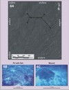
Figure 6. Details of pits and mounds. |
A
detailed inspection of the sidescan imagery shows that small pits and
mounds dimple much of the study area (Fig.
6A). The pits are mostly 1-5 m in diameter, and ROV observations suggest
they are less than 1-2 m deep (Fig.
6B). The mounds are 1-2 m in diameter, and ROV observations indicate
that they are 0.5-0.75 m high (Fig.
6C). Grouper and other large fish were observed in the ROV video imagery
consistently in or adjacent to the pits (Fig.
6B). Other studies have suggested that these pits are excavated by
fish and serve as protective habitat for them (Coleman and Williams, 2002).
The mounds in the bottom photographs and video imagery comprise carbonate
cobbles that are less than about 10 cm in diameter. Most mounds have an
opening at their bases. No fish were observed entering these openings,
however similar mounds have been observed in the Caribbean and Bahamas
and are constructed by sand tilefish (Buttner, 1996). While no sand tilefish
were observed near the mounds, they are likely responsible for constructing
these mounds. A systematic mapping of the pits and mounds is being completed,
and the geologic controls on their distribution will be the topic of a
future report.
Bottom photographs and observations along ROV transects indicate that
much of the seafloor within the study area is covered either by carbonate
rubble, algae, or corals (Jarrett and others, 2005). These observations
in concert with the multibeam bathymetry suggest that some of the features of the sidescan imagery are due to topographic effects
while others are the result of differences in the seafloor geology.
The mottled eastern flank of the ridge and the broad lineations that characterize
the western side of the ridge appear to be controlled by the fine-scale
morphology of the seafloor, as there are no obvious changes in the composition
of the seafloor observed in the ROV transects across these areas.
By contrast, the floors of the large depressions and the low-backscatter
mottled areas do show a difference in seafloor sediment type. In these
areas the sediment is mostly sand, and the veneer of carbonate rubble
that characterizes much of the remainder of the study area is absent or
greatly reduced. The high-backscatter area along the crest of the ridge
is characterized by cobble pavement that in places appears to be interrupted
by outcroppings of rock. These rock outcrops presumably are exposures
of beach rock material that was recovered in dredges from this area (Jarrett
and others, 2005). The terraces along the flanks of the ridge crest presumably
represent outcrops of this beach rock.
|
