Woods Hole Science Center
Sidescan-Sonar Imagery and Surficial Geologic Interpretations of the Sea Floor in Central Rhode Island Sound
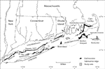
The stratigraphy in Rhode Island Sound is composed of a south-southeasterly-dipping basement of mostly pre-Mesozoic gneiss and schist, overlain in the south by late Cretaceous coastal plain sediments and throughout the Sound by Pleistocene glacial drift and Holocene fluvial and transgressional sediments (fig. 3; McMaster and others, 1968). The coastal plain sediments, which contain deeply eroded channels, form a cuesta across southern Rhode Island Sound (McMaster and others, 1968; McMaster and Ashraf, 1973). Two glacial advances across Rhode Island Sound are marked by the Ronkonkoma-Nantucket end moraines and the Harbor Hill-Roanoke Point-Charlestown-Buzzards Bay end moraines, as well as glacial drift more than 40 m thick north of the moraines (fig. 4; McMaster, 1960; McMaster and others, 1968). During glacial recession, proglacial lakes formed behind the end moraines (Needell and others, 1983c). During and after lake drainage, while sea level was near low stand, the sea floor was exposed and rivers cut drainage channels into the glacial drift, often in the locations of previously eroded valleys (McMaster and Ashraf, 1973; Needell and others, 1983c). As sea level rose, estuarine and marine sediments were deposited, while the transgressing shoreline eroded parts of the sea floor (Needell and others, 1983c). |