USGS Coastal and Marine Geology Program
Sea Floor Image Maps Showing Topography, Sun-Illuminated Topography, Backscatter Intensity, Ruggedness, Slope, and the Distribution of Boulder Ridges and Bedrock Outcrops in the Stellwagen Bank National Marine Sanctuary Region off Boston, Massachusetts
|
|||||||||||||||||||||||||||||||
|
Page C. Valentine, editor
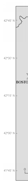
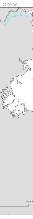
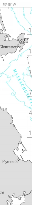
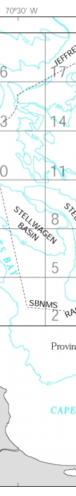
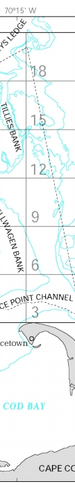
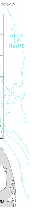
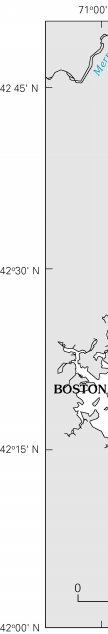
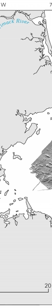
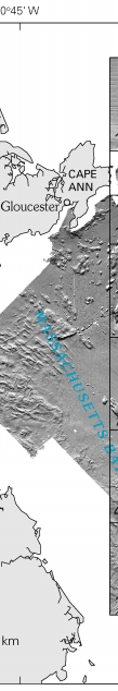
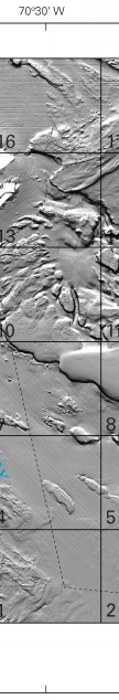
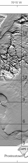
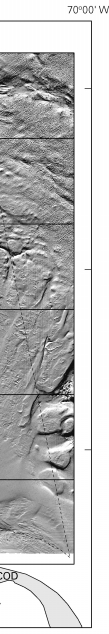
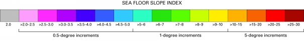
DiscussionIntroductionSea floor mapping in the Stellwagen Bank National Marine Sanctuary (NMS) is a cooperative effort of the U.S. Geological Survey (USGS) and the National Oceanic and Atmospheric Administration, with technical support from the University of New Brunswick and the Canadian Hydrographic Service. The maps generated from this undertaking are based on a 1994–96 survey that used a multibeam echo sounder to map 1,100 square nautical miles of the sea floor (fig. 1). The technology and methods of image acquisition and topographic contouring that were used are described in publication 4 in the References section. USGS Scientific Investigations Maps (SIM) 2840–A to –F constitute a six-map (twelve-sheet) series in digital (DVD-ROM) format. The first three maps, SIM 2840–A, –B, and –C, were previously published on paper as USGS Geologic Investigations Series Maps I–2676–A, –B, and –C (publications 43–45 in the References). Preliminary versions of those three maps also had been released earlier on a CD-ROM as USGS Open-File Report 00–410 (publication 42). On the maps presented in this series, the locations of the corners of the 18 quadrangles are shown for reference as ticks labeled outside the map edges, and (on maps C and E) as large crossticks within the map area. Maps A, B, D, and F show the boundaries of the individual quadrangles. On the maps that show sun-illuminated sea floor topography, blank spaces represent areas of no data. Sea floor slope and sun-illuminated topography Sea floor slope This map combines contoured and sun-illuminated topographic imagery with an analysis of sea floor slope. Slope values were derived from the digital bathymetric (topographic) grid using the slope function of ESRI Spatial Analyst software. The slope is measured in degrees and represents the maximum rate of change in elevation between a center cell (image pixel) and its eight neighboring cells, arrayed in a three-pixel by three-pixel format. Each pixel measures 13 m on a side, and is 169 m² in area. The nine-pixel array measures 39 m on a side (1,521 m²), and the slope is calculated for this area. No point in the nine-pixel area lies more than 18.4 m from the central pixel. The resolution of the bathymetric dataset determines the resolution of the slope angles that can be recognized by using this analytical technique. For example, the slope angles derived from 13-m-pixel data are not comparable with slope values of the same magnitude that have been derived from 10-m-pixel data. On this map, we have taken a new approach in displaying sea floor slope by portraying it in four slope-angle intervals, in different degree-increments, in order to recognize and illustrate better the variety of features of varying sizes that shape the seabed. We found that displaying slope values only in one-degree increments produced numerous slope increments; and the many different colors required to represent them made it difficult to interpret seabed features. Conversely, by displaying slope-angle values exclusively in increments of several degrees, we could not clearly differentiate small features such as boulder ridges that are the structural setting for the geological and biological processes that form important seabed habitats. Seabed slope angles are shown on this map using half-degree increments in the >2- to 5-degree range, one-degree increments in the >5- to 10-degree range, and five-degree increments in the >10- to 30-degree range. Slope angles of two degrees and less are shown in gray tones (fig. 3). Blank places (white) represent areas of no data. Interpretation The description of seabed features and bottom types in this discussion is based on topographic imagery and backscatter intensity (Maps B and C of this series), on video and (or) photographic imagery from 2,868 stations (Map F, Sheet 3 of this series), and on geological sediment texture analysis from 2,633 stations in the map region. The areas of the sea floor represented by the four slope-angle intervals (0–2 degrees; >2–5 degrees; >5–10 degrees; and >10–30 degrees) were calculated for each of the 18 quadrangles as well as for the area of the Stellwagen Bank NMS that lies in each quadrangle (see table 1). For the 18-quadrangle region, 89.2 percent of the sea floor has slope angles that range from 0 to 2 degrees; 8.6 percent has slopes of >2 to 5 degrees; 1.7 percent has slopes of >5 to 10 degrees; and 0.5 percent has slopes of >10 to 30 degrees. These slope values for the region as a whole also are representative of the sea floor within the Stellwagen Bank NMS that is outlined by the dashed line on the map. Sea floor steepness is distributed unevenly throughout the map region, as is reflected in the color intervals on the map and in the area calculations in table 1. The highest topographic variability, and the greatest range in slope angles, occur in areas dominated by many small close-lying banks and basins (Tillies; Polygon; Ellipse Bank and Stenos Basin; Creed Ridge and Basin; Ninety Meter Banks), in areas dominated by bedrock outcrops (Sanctuary Hill, East Hill, East and West Pigeon Hills), and along the margins of large banks (Stellwagen Bank and Jeffreys Ledge). Upwelling and oceanographic temperature fronts characteristically occur in areas of high topographic variability. Relatively smooth sea floor with slope angles in the 0- to 2-degree range (gray tones) constitutes 89 to 98 percent of 11 of the 18 quadrangles (1–9, 12, 16) and 86 to 87 percent of 4 other quadrangles (10, 13, 15, 17). In Quadrangle 10 of this latter group, 85.6 percent of the seabed has a slope angle of 0 to 2 degrees, and 11.6 percent has an angle of >2 to 5 degrees, much of which represents boulder ridges (see Map F of this series). In Quadrangle 15, 87 percent of the seabed has a slope of 0 to 2 degrees, and 12.6 percent has a slope of >2 to 5 degrees, much of which represents iceberg scours that are 5 to 10 m deep, 50 to 100 m wide, and up to several kilometers in length (see Map F, Sheet 2). The remaining three quadrangles (11, 14, 18) show more topographic variability and have not more than 77.3 percent relatively smooth sea floor (slope angles of 0–2 degrees). Quadrangle 11 exhibits the highest percentage of steep slopes; 24.9 percent of the sea floor has a slope angle of >2 to 5 degrees, which to a large extent represents gently inclined bank and basin margins and to a small extent boulder ridges; 8.8 percent of the quadrangle has slopes of >5 to 10 degrees; and 4.2 percent has slopes of >10 to 30 degrees, which represent steeply-inclined bank margins. Quadrangle 14 lies on the northern boundary of Quadrangle 11 and is somewhat similar to it geomorphologically; 15 percent of the seabed has a slope angle of >2 to 5 degrees (gently inclined bank and basin margins; boulder ridges); 5.9 percent has a slope angle of >5 to 10 degrees; and 1.7 percent has slopes of >10 to 30 degrees (steeply inclined bank margins). Quadrangle 18 contains a large area of seabed with a slope angle of >2 to 5 degrees (26.2 percent) that represents iceberg scours. Comparison of sea floor slope angles shown on this map with terrain ruggedness indices (TRI) shown on Map D of this series reveals they depict the seabed in a very similar fashion, especially for large-scale features such as the steep slopes of banks. However, when comparing the results of the slope and TRI analyses as displayed on these maps, it is clear that the TRI analysis is better at depicting small-scale features such as iceberg scour marks and boulder ridges. Compare the slope analysis on this map to the TRI analysis on Map D, Sheet 2 with respect to the iceberg scours in the northeastern part of the map region and to the boulder ridges in Quadrangle 10 on Gloucester Bank. Slope analysis is useful for describing sea floor geomorphology and for identifying the effects of seabed processes when combined with interpretations of seabed topographic imagery, backscatter intensity, video and photographic imagery, and sediment texture analysis. Over time, physical processes change the shape of the seabed and produce geomorphological signatures that are visible on slope maps. For example, the relatively constant slope along a bank margin sometimes is interrupted by a section that is less steep. One explanation is that sediment has been transported by bottom currents off the bank onto the margin, thereby reducing the seabed slope there. Examples of this process are located along a 7-km section of the southeastern margin of Jeffreys Ledge (42°40' N., 70°22.5' W.), the Northwest Corner on Stellwagen Bank (42°25.5' N., 70°28.5' W.), and the western margin of Stellwagen Bank south of Western Spur (42°17.25' N., 70°20.25' W.). See the discussion on Map D of sea floor geomorphology based on terrain ruggedness analysis. References USGS publications can also be purchased from USGS Information Services, Box 25286, Denver Federal Center, Denver, CO 80225-0046; telephone (303) 202-4200 or 1-888-ASK-USGS Massachusetts Bay Disposal Site—Maps and Features 1. Valentine, P.C., Baker, J.L., Unger, T.S., Evans, John, and Polloni, C.F., 1999, Sea floor topographic, backscatter, and interpretive maps and bottom photos of the Massachusetts Bay Disposal Site region off Boston, Massachusetts: U.S. Geological Survey Open-File Report 98–344, 1 CD-ROM. (Also available online at http://pubs.usgs.gov/of/of98-344/) 2. Valentine, P.C., Danforth, W.W., Roworth, E.T., and Stillman, S.T., 1996, Maps showing topography, backscatter, and interpretation of sea floor features in the Massachusetts Bay Disposal Site region off Boston, Massachusetts: U.S. Geological Survey Open-File Report 96–273, 2 sheets, scale 1:10,000 and 1:12,500. Massachusetts and Cape Cod Bays and Stellwagen Bank National Marine Sanctuary—Sea Floor Topography 3. Valentine, P.C., Schmuck, E.A., Signell, R.P., and Ryland, C.A., 1995, Sea floor topography of Massachusetts and Cape Cod Bays and Stellwagen Bank National Marine Sanctuary: U.S. Geological Survey Open-File Report 95–073, scale 1:100,000. Stellwagen Bank National Marine Sanctuary—Sea Floor Topography 4. Valentine, P.C., Baker, J.L., Unger, T.S., and Polloni, C.F., 1998, Sea floor topographic map and perspective-view imagery of Quadrangles 1–18, Stellwagen Bank National Marine Sanctuary off Boston, Massachusetts: U.S. Geological Survey Open-File Report 98–138, 1 CD-ROM. (Also available online at http://pubs.usgs.gov/of/of98-138/) 5. Valentine, P.C., Baker, J.L., Unger, T.S., and Roworth, E.T., 1997, Sea floor topography of Quadrangle 1 in the Stellwagen Bank National Marine Sanctuary off Boston, Massachusetts: U.S. Geological Survey Open-File Report 97–502, scale 1:25,000. 6. Valentine, P.C., Unger, T.S., Baker, J.L., and Roworth, E.T., 1997, Sea floor topography of Quadrangle 2 in the Stellwagen Bank National Marine Sanctuary off Boston, Massachusetts: U.S. Geological Survey Open-File Report 97–503, scale 1:25,000. 7. Valentine, P.C., Baker, J.L., Unger, T.S., and Roworth, E.T., 1997, Sea floor topography of Quadrangle 3 in the Stellwagen Bank National Marine Sanctuary off Boston, Massachusetts: U.S. Geological Survey Open-File Report 97–504, scale 1:25,000. 8. Valentine, P.C., Unger, T.S., Baker, J.L., and Roworth, E.T., 1997, Sea floor topography of Quadrangle 4 in the Stellwagen Bank National Marine Sanctuary off Boston, Massachusetts: U.S. Geological Survey Open-File Report 97–505, scale 1:25,000. 9. Valentine, P.C., Baker, J.L., Unger, T.S., and Roworth, E.T., 1997, Sea floor topography of Quadrangle 5 in the Stellwagen Bank National Marine Sanctuary off Boston, Massachusetts: U.S. Geological Survey Open-File Report 97–506, scale 1:25,000. 10. Valentine, P.C., Unger, T.S., Baker, J.L., and Roworth, E.T., 1997, Sea floor topography of Quadrangle 6 in the Stellwagen Bank National Marine Sanctuary off Boston, Massachusetts: U.S. Geological Survey Open-File Report 97–507, scale 1:25,000. 11. Valentine, P.C., Baker, J.L., Unger, T.S., and Roworth, E.T., 1997, Sea floor topography of Quadrangle 7 in the Stellwagen Bank National Marine Sanctuary off Boston, Massachusetts: U.S. Geological Survey Open-File Report 97–508, scale 1:25,000. 12. Valentine, P.C., Unger, T.S., Baker, J.L., and Roworth, E.T., 1997, Sea floor topography of Quadrangle 8 in the Stellwagen Bank National Marine Sanctuary off Boston, Massachusetts: U.S. Geological Survey Open-File Report 97–509, scale 1:25,000. 13. Valentine, P.C., Baker, J.L., Unger, T.S., and Roworth, E.T., 1997, Sea floor topography of Quadrangle 9 in the Stellwagen Bank National Marine Sanctuary off Boston, Massachusetts: U.S. Geological Survey Open-File Report 97–682, scale 1:25,000. 14. Valentine, P.C., Unger, T.S., Baker, J.L., and Roworth, E.T., 1997, Sea floor topography of Quadrangle 10 in the Stellwagen Bank National Marine Sanctuary off Boston, Massachusetts: U.S. Geological Survey Open-File Report 97–683, scale 1:25,000. 15. Valentine, P.C., Baker, J.L., Unger, T.S., and Roworth, E.T., 1997, Sea floor topography of Quadrangle 11 in the Stellwagen Bank National Marine Sanctuary off Boston, Massachusetts: U.S. Geological Survey Open-File Report 97–684, scale 1:25,000. 16. Valentine, P.C., Unger, T.S., Baker, J.L., and Roworth, E.T., 1997, Sea floor topography of Quadrangle 12 in the Stellwagen Bank National Marine Sanctuary off Boston, Massachusetts: U.S. Geological Survey Open-File Report 97–685, scale 1:25,000. 17. Valentine, P.C., Baker, J.L., Unger, T.S., and Roworth, E.T., 1997, Sea floor topography of Quadrangle 13 in the Stellwagen Bank National Marine Sanctuary off Boston, Massachusetts: U.S. Geological Survey Open-File Report 97–726, scale 1:25,000. 18. Valentine, P.C., Unger, T.S., Baker, J.L., and Roworth, E.T., 1997, Sea floor topography of Quadrangle 14 in the Stellwagen Bank National Marine Sanctuary off Boston, Massachusetts: U.S. Geological Survey Open-File Report 97–727, scale 1:25,000. 19. Valentine, P.C., Baker, J.L., Unger, T.S., and Roworth, E.T., 1997, Sea floor topography of Quadrangle 15 in the Stellwagen Bank National Marine Sanctuary off Boston, Massachusetts: U.S. Geological Survey Open-File Report 97–728, scale 1:25,000. 20. Valentine, P.C., Unger, T.S., Baker, J.L., and Roworth, E.T., 1997, Sea floor topography of Quadrangle 16 in the Stellwagen Bank National Marine Sanctuary off Boston, Massachusetts: U.S. Geological Survey Open-File Report 97–729, scale 1:25,000. 21. Valentine, P.C., Baker, J.L., Unger, T.S., and Roworth, E.T., 1997, Sea floor topography of Quadrangle 17 in the Stellwagen Bank National Marine Sanctuary off Boston, Massachusetts: U.S. Geological Survey Open-File Report 97–730, scale 1:25,000. 22. Valentine, P.C., Unger, T.S., Baker, J.L., and Roworth, E.T., 1997, Sea floor topography of Quadrangle 18 in the Stellwagen Bank National Marine Sanctuary off Boston, Massachusetts: U.S. Geological Survey Open-File Report 97–731, scale 1:25,000. Stellwagen Bank National Marine Sanctuary—Sun-Illuminated Sea Floor Topographic Imagery 23. Valentine, P.C., Unger, T.S., Baker, J.L., and Polloni, C.F., 2000, Sun-illuminated sea floor topographic maps and perspective-view imagery of Quadrangles 1–18, Stellwagen Bank National Marine Sanctuary off Boston, Massachusetts: U.S. Geological Survey Open-File Report 99–363, 1 CD-ROM. (Also available online at http://pubs.usgs.gov/of/of99-363/) 24. Valentine, P.C., Baker, J.L., and Unger, T.S., 2000, Sun-illuminated sea floor topography of Quadrangle 1 in the Stellwagen Bank National Marine Sanctuary off Boston, Massachusetts: U.S. Geological Survey Geologic Investigations Series Map I–2701, scale 1:25,000. 25. Valentine, P.C., Unger, T.S., and Baker, J.L., 1999, Sun-illuminated sea floor topography of Quadrangle 2 in the Stellwagen Bank National Marine Sanctuary off Boston, Massachusetts: U.S. Geological Survey Geologic Investigations Series Map I–2702, scale 1:25,000. 26. Valentine, P.C., Baker, J.L., and Unger, T.S., 1999, Sun-illuminated sea floor topography of Quadrangle 3 in the Stellwagen Bank National Marine Sanctuary off Boston, Massachusetts: U.S. Geological Survey Geologic Investigations Series Map I–2703, scale 1:25,000. 27. Valentine, P.C., Unger, T.S., and Baker, J.L., 2000, Sun-illuminated sea floor topography of Quadrangle 4 in the Stellwagen Bank National Marine Sanctuary off Boston, Massachusetts: U.S. Geological Survey Geologic Investigations Series Map I–2704, scale 1:25,000. 28. Valentine, P.C., Baker, J.L., and Unger, T.S., 1999, Sun-illuminated sea floor topography of Quadrangle 5 in the Stellwagen Bank National Marine Sanctuary off Boston, Massachusetts: U.S. Geological Survey Geologic Investigations Series Map I–2705, scale 1:25,000. 29. Valentine, P.C., Unger, T.S., and Baker, J.L., 1999, Sun-illuminated sea floor topography of Quadrangle 6 in the Stellwagen Bank National Marine Sanctuary off Boston, Massachusetts: U.S. Geological Survey Geologic Investigations Series Map I–2706, scale 1:25,000. 30. Valentine, P.C., Baker, J.L., and Unger, T.S., 1999, Sun-illuminated sea floor topography of Quadrangle 7 in the Stellwagen Bank National Marine Sanctuary off Boston, Massachusetts: U.S. Geological Survey Geologic Investigations Series Map I–2707, scale 1:25,000. 31. Valentine, P.C., Unger, T.S., and Baker, J.L., 1999, Sun-illuminated sea floor topography of Quadrangle 8 in the Stellwagen Bank National Marine Sanctuary off Boston, Massachusetts: U.S. Geological Survey Geologic Investigations Series Map I–2708, scale 1:25,000. 32. Valentine, P.C., Baker, J.L., and Unger, T.S., 2000, Sun-illuminated sea floor topography of Quadrangle 9 in the Stellwagen Bank National Marine Sanctuary off Boston, Massachusetts: U.S. Geological Survey Geologic Investigations Series Map I–2709, scale 1:25,000. 33. Valentine, P.C., Unger, T.S., and Baker, J.L., 2000, Sun-illuminated sea floor topography of Quadrangle 10 in the Stellwagen Bank National Marine Sanctuary off Boston, Massachusetts: U.S. Geological Survey Geologic Investigations Series Map I–2710, scale 1:25,000. 34. Valentine, P.C., Baker, J.L., and Unger, T.S., 2000, Sun-illuminated sea floor topography of Quadrangle 11 in the Stellwagen Bank National Marine Sanctuary off Boston, Massachusetts: U.S. Geological Survey Geologic Investigations Series Map I–2711, scale 1:25,000. 35. Valentine, P.C., Unger, T.S., and Baker, J.L., 2000, Sun-illuminated sea floor topography of Quadrangle 12 in the Stellwagen Bank National Marine Sanctuary off Boston, Massachusetts: U.S. Geological Survey Geologic Investigations Series Map I–2712, scale 1:25,000. 36. Valentine, P.C., Baker, J.L., and Unger, T.S., 2001, Sun-illuminated sea floor topography of Quadrangle 13 in the Stellwagen Bank National Marine Sanctuary off Boston, Massachusetts: U.S. Geological Survey Geologic Investigations Series Map I–2713, scale 1:25,000. 37. Valentine, P.C., Unger, T.S., and Baker, J.L., 2001, Sun-illuminated sea floor topography of Quadrangle 14 in the Stellwagen Bank National Marine Sanctuary off Boston, Massachusetts: U.S. Geological Survey Geologic Investigations Series Map I–2714, scale 1:25,000. 38. Valentine, P.C., Baker, J.L., and Unger, T.S., 2001, Sun-illuminated sea floor topography of Quadrangle 15 in the Stellwagen Bank National Marine Sanctuary off Boston, Massachusetts: U.S. Geological Survey Geologic Investigations Series Map I–2715, scale 1:25,000. 39. Valentine, P.C., Unger, T.S., and Baker, J.L., 2001, Sun-illuminated sea floor topography of Quadrangle 16 in the Stellwagen Bank National Marine Sanctuary off Boston, Massachusetts: U.S. Geological Survey Geologic Investigations Series Map I–2716, scale 1:25,000. 40. Valentine, P.C., Baker, J.L., and Unger, T.S., 2001, Sun-illuminated sea floor topography of Quadrangle 17 in the Stellwagen Bank National Marine Sanctuary off Boston, Massachusetts: U.S. Geological Survey Geologic Investigations Series Map I–2717, scale 1:25,000. 41. Valentine, P.C., Unger, T.S., and Baker, J.L., 2001, Sun-illuminated sea floor topography of Quadrangle 18 in the Stellwagen Bank National Marine Sanctuary off Boston, Massachusetts: U.S. Geological Survey Geologic Investigations Series Map I–2718, scale 1:25,000. Stellwagen Bank National Marine Sanctuary—Sun-Illuminated Sea Floor Topographic Imagery and Backscatter Intensity 42. Valentine, P.C., Middleton, T.J., and Fuller, S.J., 2001, Sea floor maps showing topography, sun-illuminated topography, and backscatter intensity of the Stellwagen Bank National Marine Sanctuary region off Boston, Massachusetts: U.S. Geological Survey Open-File Report 00–410, 1 CD-ROM. (Also available online at http://pubs.usgs.gov/of/of00-410/) (Superseded by maps I–2676–A, –B, and –C; see publications 43–45 in this list.) 43. Valentine, P.C., Baker, J.L., and Unger, T.S., 2003, Sea floor topography of the Stellwagen Bank National Marine Sanctuary off Boston, Massachusetts: U.S. Geological Survey Geologic Investigations Series Map I–2676–A, scale 1:60,000. 44. Valentine, P.C., Unger, T.S., and Baker, J.L., 2003, Sun-illuminated sea floor topography of the Stellwagen Bank National Marine Sanctuary off Boston, Massachusetts: U.S. Geological Survey Geologic Investigations Series Map I–2676–B, scale 1:60,000. 45. Valentine, P.C., Unger, T.S., and Baker, J.L., 2003, Backscatter intensity and sun-illuminated sea floor topography of the Stellwagen Bank National Marine Sanctuary off Boston, Massachusetts: U.S. Geological Survey Geologic Investigations Series Map I–2676–C, scale 1:60,000. Stellwagen Bank National Marine Sanctuary—Seabed Ruggedness and Distribution of Boulder Ridges and Bedrock Outcrops 46. Valentine, P.C., Fuller, S.J., and Scully, L.A. [2004], Terrain ruggedness analysis and distribution of boulder ridges and bedrock outcrops in the Stellwagen Bank National Marine Sanctuary region—seabed ruggedness: U.S. Geological Survey poster available online at http://woodshole.er.usgs.gov/project-pages/stellwagen/posters/rugged.html (Downloaded July 27, 2005.) 47. Valentine, P.C., Scully, L.A., and Fuller, S.J. [2004], Terrain ruggedness analysis and distribution of boulder ridges and bedrock outcrops in the Stellwagen Bank National Marine Sanctuary region—boulder ridges and bedrock outcrops: U.S. Geological Survey poster available online at http://woodshole.er.usgs.gov/project-pages/stellwagen/posters/ridges.html (Downloaded July 27, 2005.) Terrain Ruggedness Index (TRI) 48. Riley, S.J., DeGloria, S.D, and Elliott, R., 1999, A terrain ruggedness index that quantifies topographic heterogeneity: Intermountain Journal of Sciences, v. 5, no. 1-4, p. 23–27.
|
|||||||||||||||||||||||||||||||
| |||||||||||||||||||||||||||||||