USGS - science for a changing world

USGS Coastal and Marine Geology Program


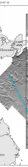
Sea Floor Image Maps Showing Topography, Sun-Illuminated Topography, Backscatter Intensity, Ruggedness, Slope, and the Distribution of Boulder Ridges and Bedrock Outcrops in the Stellwagen Bank National Marine Sanctuary Region off Boston, Massachusetts

U.S. Geological Survey Scientific Investigations Map 2840

Page C. Valentine, editor

2005


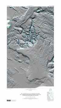
A.  Sea Floor Topography in the Stellwagen Bank National Marine
       Sanctuary Region
       By Page C. Valentine, Jessica L. Baker, and Tanya S. Unger

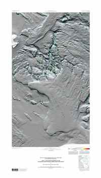
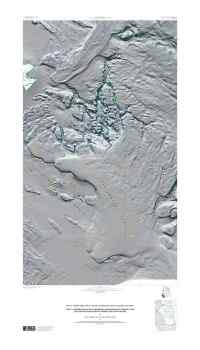
B.  Sun-Illuminated Sea Floor Topography in the Stellwagen Bank
       National Marine Sanctuary Region
       By Page C. Valentine, Tanya S. Unger, and Jessica L. Baker

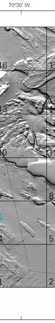
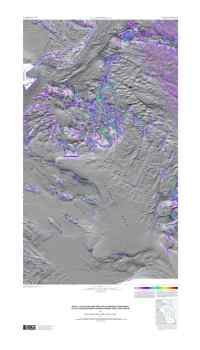
C.  Backscatter Intensity and Sun-Illuminated Sea Floor Topography
       in the Stellwagen Bank National Marine Sanctuary Region
       By Page C. Valentine, Tanya S. Unger, and Jessica L. Baker

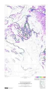
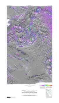
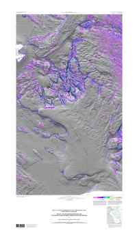
D.  Sea Floor Ruggedness in the Stellwagen Bank National Marine
       Sanctuary Region
       By Page C. Valentine, Lian A. Scully, and Sarah J. Fuller
            Sheet 1.—General sea floor ruggedness and topography.
            Sheet 2.—General sea floor ruggedness and sun-illuminated
                              topography.
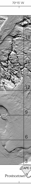
            Sheet 3.—Sea floor ruggedness in the >30- to
                              100-centimeter range and sun-illuminated
                               topography.
            Sheet 4.—Sea floor ruggedness in the >1- to 2-meter range
                              and sun-illuminated topography.
            Sheet 5.—Sea floor ruggedness in the >2- to 6-meter range
                              and sun-illuminated topography.

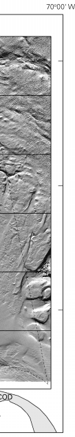
E.  Sea Floor Slope and Sun-Illuminated Topography in the Stellwagen
       Bank National Marine Sanctuary Region
       By Page C. Valentine, Sarah J. Fuller, and Lian A. Scully

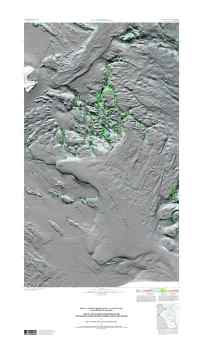
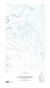
F.  Distribution of Boulder Ridges and Bedrock Outcrops in the
       Stellwagen Bank National Marine Sanctuary Region
       By Page C. Valentine, Lian A. Scully, and Sarah J. Fuller
            Sheet 1.—Boulder ridges, bedrock outcrops, and sea floor
                              topography.
            Sheet 2.—Boulder ridges, bedrock outcrops, and sun-illuminated
                              sea floor topography.
            Sheet 3.—Boulder ridges, bedrock outcrops, sun-illuminated
                              sea floor topography, and stations.

U.S. Geological Survey Scientific Investigations Map 2840

2005, Version 1.0

Prepared in cooperation with the National Oceanic and Atmospheric Administration


Location of the Map Area in the Stellwagen Bank NMS region

Figure 1.  Regional setting of the map area. Figure 1. Regional setting of the map area . Figure 1. Regional setting of the map area . Figure 1.  Regional setting of the map area. Figure 1. Regional setting of the map area . Figure 1. Regional setting of the map area .

Figure 1.  Regional setting of the map area (outlined in black). Publications specific to the entire map area or to individual quadrangles 1–18 (outlined in gray) are listed in the References section. Stellwagen Bank National Marine Sanctuary (SBNMS) boundary is shown as a dashed line. Bathymetric contours are labeled in meters.


Figure 2.  Sun-illuminated sea floor topographic imagery of the Stellwagen Bank National Marine Sanctuary and Massachusetts Bay region. Figure 2.  Sun-illuminated sea floor topographic imagery of the Stellwagen Bank National Marine Sanctuary and Massachusetts Bay region. Figure 2.  Sun-illuminated sea floor topographic imagery of the Stellwagen Bank National Marine Sanctuary and Massachusetts Bay region. Figure 2.  Sun-illuminated sea floor topographic imagery of the Stellwagen Bank National Marine Sanctuary and Massachusetts Bay region. Figure 2.  Sun-illuminated sea floor topographic imagery of the Stellwagen Bank National Marine Sanctuary and Massachusetts Bay region. Figure 2.  Sun-illuminated sea floor topographic imagery of the Stellwagen Bank National Marine Sanctuary and Massachusetts Bay region.

Figure 2.  Sun-illuminated sea floor topographic imagery of the Stellwagen Bank National Marine Sanctuary and Massachusetts Bay region, and the 18 quadrangles of the map area. Dashed line is the sanctuary boundary.


Previews of USGS Scientific Investigations Map 2840

Map A.
Map A


Map B.
Map B


Map C.
Map C


Map D, Sheet 1.
Map D, Sheet 1


Map D, Sheet 2.
Map D, Sheet 2


Map D, Sheet 3.
Map D, Sheet 3


Map D, Sheet 4.
Map D, Sheet 4


Map D, Sheet 5.
Map D, Sheet 5


Map E
Map E


Map F, Sheet 1.
Map F, Sheet 1


Map F, Sheet 2.
Map F, Sheet 2


Map F, Sheet 3.
Map F, Sheet 3


Skip Footer Information

Adobe Reader To view files in PDF format, download free copy of Adobe Reader.


Any use of trade names is for descriptive purposes only and does not imply endorsement by the U.S. Government.


Skip Navigation

Accessibility FOIA Privacy Policies and Notices

U.S. Department of the Interior | U.S. Geological Survey | Coastal and Marine Geology

URL: cmgds.marine.usgs.gov/publications/sim2840/INDEX.HTML
Page Contact Information: CMGDS Team
Page Last Modified: Thursday, 27-Apr-2023 15:27:01 EDT