|
U.S. Geological Survey Open-File Report 02-002
Geological Framework Data from Long Island Sound, 1981-1990:
A Digital Data Release
East-Central Long Island Sound: Summary Report
![]()
|
|
USGS MISCELLANEOUS FIELD STUDIES MAP MF-1939-BThe report presented below (Needell and others, 1987) was previously published as a Miscellaneous Field Studies Map by the U.S. Geological Survey and is included here solely to broaden the perspective and understanding of those individuals interested in the geologic framework and the Late Quaternary depositional history of east-central Long Island Sound. The results presented in Needell and others (1987) are preliminary. Final interpretations and a regional perspective are presented in Lewis and Stone (1991) and Lewis and DiGiacomo-Cohen (2000).
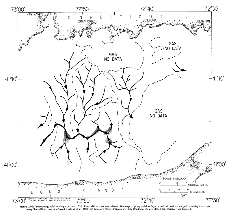
THE QUATERNARY GEOLOGY OF EAST-CENTRAL LONG ISLAND SOUNDSally W. Needell, Ralph S. Lewis, and Steven M. ColmanU.S. Geological Survey Miscellaneous Field Studies Map MF-1939-B1987ABSTRACTThe stratigraphic framework and Quaternary geologic history of east-central Long Island Sound are revealed by high-resolution seismic-reflection profiles and vibracores, supplemented by information from previous studies in the Sound and surrounding areas. Seven sedimentary units are identified in the seismic profiles: (1) coastal-plain strata of Late Cretaceaous age, (2) stratified glacial drift of Pleistocene age, (3) end-moraine deposits of Pleistocene age, (4) till of Pleistocene age, (5) lower glacial lake deposits of late Pleistocene age, (6) upper lacustrine and fluvial deposits of late Pleistocene to Holocene age, and (7) marine deposits of Holocene age. The fluvial preglacial drainage pattern has been modified by glacial erosion, but is readily reconstructed. It is marked by a major north-trending drainage divide that precludes a previously suggested major through-flowing river in Long Island Sound. To the west of the divide, the valleys of the three south-flowing tributaries cut in coastal-plain sediments and bedrock and three north-flowing valleys cut entirely in coastal-plain strata, join an apparently west-flowing trunk stream. The drainage system east of the divide is obscured in seismic records by younger gas-charged sediments, but one major southeast-flowing tributary valley can be identified. These valleys were fluvially cut during times of lower sea level in the Tertiary and early Pleistocene(-) by streams flowing south from Connecticut and north from Long Island. Pleistocene glaciers modified the drainage system by over-deepening the valleys, especially along the axis of the west-flowing trunk stream, where three closed depressions were formed and by making them more U-shaped. Stratified drift, till, and end-moraine deposits were deposited over a modified fluvial landscape during the Pleistocene ice advances. As the last ice (late Wisconsinan) retreated, meltwater was trapped north of the end moraines in the deep valleys of the Sound, forming glacial lakes that later coalesced to form one glacial lake. Extensive laminated, fine-grained lake sediments, mostly silty clay, were deposited throughout the area. The upper part of the lake clay interfingers with and was covered by coarser lake deposits, presumably derived from glacial and post-glacial fluvial sediments to the north. The deposits that overlie the lake clays show a transition from lake bottom to deltaic to fluvial environments. This transition suggests that the main lake basin drained and the lake level lowered, although smaller, localized lakes may have persisted until the marine transgression. As sea level rose, estuarine sediments were deposited in channels on the exposed parts of the fluvial-deltaic surface, but subsequent wave action reworked the uppermost fluvial and estuarine sediment and glacial drift, smoothing the sea floor. During Holocene time, as much as 20m of marine sediments were deposited atop the marine unconformity. INTRODUCTION
Previous work in central Long- Island Sound primarily addressed the morphology of the top of the crystalline bedrock and coastal-plain strata, and the near-shore distribution of glacial and postglacial deposits. Oliver and Drake (1951) presented the first bedrock map of Long Island Sound. Later, Tagg and Uchupi (1967) further described the surface of the bedrock and Grim and others (1970) mapped the surface of the crystalline bedrock and coastal-plain strata. Prior to this mapping, a fluvial origin for the lowland occupied by Long Island Sound had been suggested by Dana (1890), Veatch (1906), and Fuller (1914), and this suggestion was shared by Grim and others (1970). Hollick (1893) and other early researchers speculated that Long Island Sound was once occupied by a glacial lake. Later Newman and Fairbridge (1960) presented additional suggestions of a glacial lake in Long Island Sound. However, the first direct evidence (lake clay) for this glacial lake was collected in Block Island Sound (Frankel and Thomas, 1966; Bertoni and others, 1977). Flint and Gebert (1976) and Williams (1981) discussed the distribution of submerged Pleistocene deposits along the Connecticut coast. Williams (1981) also discussed the distribution of bottom sediments in central Long Island Sound. Overviews of the geology of Long Island Sound have been presented by Grim and others (1970), Gordon (1980), and Williams (1981). We have prepared similar maps to the ones presented here for Pleistocene deposits in Block Island Sound (Needell and Lewis, 1984) and Eastern Long Island Sound (Lewis and Needell, 1987). In these reports, we discussed the surface morphology of the bedrock and coastal-plain sediments and the distribution, thickness, and morphology of glacial deposits, including sediments related to the glacial lake in Long Island Sound, and postglacial deposits. ACKNOWLEDGMENTSThe authors wish to thank Arthur D. Colburn, Captain of the R/V ASTERIAS of the Woods Hole Oceanographic Institution, Robert N. Oldale, Stewart Richards and Jack Connell for their assistance during the cruise. We would also like to thank Gerald Edwards for his help in the compilation of the data. GEOLOGIC SETTINGMost of the bedrock beneath east-central Long Island Sound is believed to be composed of metamorphic and igneous rock of pre-Mesozoic age. The bedrock geologic map of Connecticut (Rodgers, 1985) shows that the Connecticut coast north of the study area is underlain by Paleozoic granitic and gneissic rocks of the Appalachian orogen. The bedrock surface dips southward from the Connecticut coast (Grim and others, 1970) and drill holes have penetrated granitic gneiss at about 330 m below sea level beneath north-central and northeastern Long Island (de Laguna, 1963; Pierce and Taylor, 1975). Coastal-plain strata, composed of unconsolidated and semi-consolidated gravel, sand, silt and clay of Late Cretaceous age, are present along the north shore of Long Island (Fuller, 1914; Suter and others, 1949; de Laguna, 1963). These strata unconformably overlie the bedrock beneath the Sound but are not present on the Connecticut coast adjacent to the study area (Grim and others, 1970). Glacial drift unconformably overlies bedrock in southern Connecticut and coastal-plain strata along the north shore of Long Island. The glacial drift forms two drift sheets, one of pre late-Wisconsinan age and one of late Wisconsinan age (Donner, 1964; Sirkin, 1971, 1976, 1982; Mills and Wells, 1974). Two belts of end moraines cross southern New England (Schafer and Hartshorn, 1965). The outermost moraine belt extends from central and southeastern Long Island eastward to Georges Bank (east of Figure 1); it marks the maximum seaward extent of ice at the last glacial maximum. The inner belt of end moraines lies along the north shore of Long Island, Fishers Island, coastal Rhode Island, the Elizabeth Islands and Cape Cod. Less prominent recessional moraines probably lie between the two major moraines in eastern Long Island (Sirkin, 1982). Several small moraine segments have been recognized along the coast of Connecticut and in northern Long Island Sound just south of Branford and Clinton, Conn. (Flint and Gebert, 1976; Goldsmith, 1982). Methods
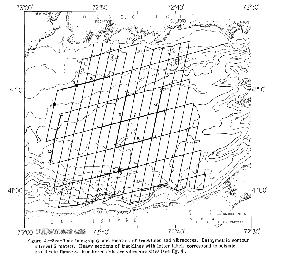
Three cores (Figure 2) were collected using the Alpine Ocean Seismic Survey Vibracorer, which is capable of collecting a core 9 cm in diameter and up to 9 m in length in water depths up to 60 m. The vibracorer uses a pneumatic impacting piston vibrator on top of core pipe fitted with a core liner to penetrate the sediments. U.S. Coast and Geodetic Survey Bathymetric Map 0808N-53 (U.S. Department of Commerce, 1967), published at a scale of 1:125,000, was used as the base map for this study. This map was also used to provide the bathymetry shown in Figure 2. Major acoustic reflectors and units were identified on the basis of their acoustic signal and inferred correlation to stratigraphic control available in and adjacent to the study area. Velocity data for the sediments is scarce and of variable quality (Tuttle and others, 1961); we assumed that the compressional-wave velocities of the sediments are as follows: 1,500 m/s for water and sediments inferred to be of Holocene age, 1,800 m/s for sediments inferred to be of Pleistocene age, and 2,500 m/s for sediments inferred to be coastal-plain strata of Late Cretaceous age. Some parts of the study area are underlain by gas-charged sediments. The gas is probably biogenic methane produced in fine-grained sediment by the decay of organic matter. In these areas, labeled "GAS NO DATA" on the maps (Figure 5, 6, 7, 8, 9, 10, 11, 12 and 13), the top of the gas-bearing sediments produces a characteristic pattern of a strong reflection and scattering of seismic energy (small pockets of gassy sediments are present on the profile in Figure 3E). Lower seismic reflectors in these areas are obscured and map units could not be identified. Sea-floor TopographyEast-central Long Island Sound has a generally smooth sea floor (Figure 2). The sea floor gradually deepens southeastward from the Connecticut coast to the central portion of the Sound, which lies 25-30 m below present sea level. The sea floor slopes more steeply northward from the Long Island coast. A relatively flat area just north of Roanoke Point is flanked by two elongate depressions parallel to the coast, one open to the west and the other to the northeast. The depression that occupies the southwest corner of the study area is more than 45 m below sea level. Its morphology and its appearance on seismic profiles suggest that the western third of this depression is being scoured by modern currents. StratigraphyPhotographs and matching line drawings (Figures 3A, 3B, 3C, 3D, 3F, 3G) illustrate our interpretations of the seismic-reflection profiles. Crystalline bedrock (e.g. Figure 3A, unit Pz) is the oldest stratigraphic unit that can be recognized on the profiles. Where detected, the surface of this bedrock forms acoustic basement and a prominent, continuous, but irregular reflector. The south-dipping bedrock surface can be traced seaward from the Connecticut coast, where it occurs at the sea floor; the surface has comparable relief both onshore and offshore. Drill holes on north-central and northeastern Long Island have penetrated granitic gneiss at about 330 m below sea level (de Laguna, 1963; Pierce and Taylor, 1975). We thus infer that the bedrock beneath east-central Long Island Sound is similar to the Paleozoic gneissic and granitic bedrock along the adjacent Connecticut coast and beneath northern Long Island. In the southern two-thirds of the study area, energy from our seismic system did not penetrate to crystalline bedrock. In this area, the bedrock is overlain by a stratigraphic unit that is characterized by a strong surface reflection and by the local presence of nearly continuous, subhorizontal internal reflectors. We infer that this unit (e.g. Figure 3D, unit Ku) represents coastal-plain sediments of Cretaceous age. Near the margins of the coastal-plain strata where these strata are thin, the bedrock surface (e.g. Figure 3A, unconformity uf3) can be traced for a short distance beneath the coastal-plain sediments, but we were not able to map the bedrock surface where it lies under thicker coastal-plain deposits. Similar relations between coastal-plain deposits and crystalline bedrock have been observed throughout the inner shelf of southern New England (Grim and others, 1970; O'Hara and Oldale, 1980; Needell and Lewis, 1984). A prominent acoustic reflector (e.g. Figure 3D, unconformity uf2) is present at the top of coastal-plain strata and, where coastal-plain strata are absent, at the top of the crystalline bedrock. This unconformity is continuous, but highly irregular. It represents a composite surface formed originally by fluvial erosion that was later modified by glacial processes. Glacial drift unconformably overlies the crystalline bedrock and coastal- plain strata. The drift includes outwash, till, ice-contact stratified drift, drift deformed by overriding ice, and glacial lake deposits. The drift is subdivided according to its acoustic character, stratigraphic position, and relation to onshore geomorphic features. The composition of the drift units is inferred from limited core data and from analogy to similar deposits above sea level. Outwash and ice-contact stratified drift (unit Qd, Figures 3C, 3D, and 3G) is characterized by conformable, subhorizontal internal reflectors. It is probably composed chiefly of sand and gravel, with lesser amounts of silt and clay. Till (unit Qt, e.g. Figure 3B) and end-moraine deposits (unit Qtm, Figure 3D) are recognized by a well-defined upper reflector that obscures the underlying reflections. Where internal reflectors can be seen they are highly irregular and discontinuous. As inferred from similar deposits on land, till is mostly large clasts in a sandy to clayey matrix. End-moraine deposits are composed of till, stratified drift, and incorporated interglacial and preglacial sediments, much of which has been deformed by overriding ice. Both till and end-moraine deposits form positive relief features. We mapped end-moraine deposits where the relief is clearly an extension of onshore end moraines, and till where the detailed morphology is less certain. The glacial lake deposits are divided into two units. The lower unit (unit Qgl, Figure 3B) is characterized by acoustically laminated internal reflectors that mimic the topography of the underlying deposits. Core data from nearby areas (Lewis, Colman, and Needell, unpublished data) and previous studies (Frankel and Thomas, 1966; Bertoni and others, 1977) indicate that the lower glacial lake deposits are composed primarily of laminated (probably varved) silt and clay, with local lenses of coarser sediment.
The uppermost part of the lacustrine and fluvial unit locally is marked by minor, filled channels that are truncated by the marine unconformity (um)
(Figures 3B, 3D,
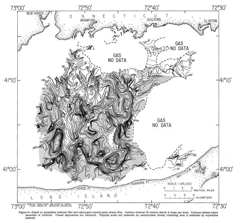
3G). The fill in these small channels is too small to map, but is probably correlative with the fluvial and estuarine unit mapped farther east (unit Qfe of Needell and Lewis, 1984; Lewis and Needell, 1987). Previous work (O'Hara and Oldale, 1980) indicates that the channel-fill deposits are composed of fluvial gravel and sand; estuarine sand, silt, and clay; and freshwater and saltwater peat. In contrast The marine unconformity (um, Figure 3B) is represented by a strong, continuous, subhorizontal reflector. It is overlain by llolocene marine sediments (unit Qhm, Figure 3B), which make up the bulk of the post-glacial deposits. They exhibit persistent, subhorizontal internal reflectors. These flat-lying sediments cover most of the study area (Figure 5) and were cored in three places (Figure 4). They are composed mostly of silty clay and silty sand, but they contain zones of fine-grained sand and shell material. Submerged beach deposits (Figures 3B and 3C) contain flat-lying to gently dipping internal reflectors that are truncated by a dipping reflector with positive relief that represents the paleoshoreface. The beach deposits are thought to be composed primarily of sand and gravel. Their distribution is extremely limited and they are not used as a map or stratigraphic unit here. Depth to Crystalline Bedrock and Submerged Coastal-plain StrataThe morphology of the glacially modified fluvial unconformity (uf2) and the distribution of units below the unconformity (Figure 6) shows that coastal- plain strata overlie bedrock in most of east-central Long Island Sound. Where not obscured by gas, the coastal-plain strata can be traced to within 6.5 km of the Connecticut coast. Remnants of the coastal-plain strata probably extend below the gassy area southeast of Branford, Conn. The preservation of coastal-plain sediments throughout most of the east-central part of the Sound contrasts with their limited preservation in areas farther east (Lewis and Needell, 1987). In addition, the coastal-plain strata in the east-central part of the Sound do not form a prominent north-facing cuesta as they do farther east.
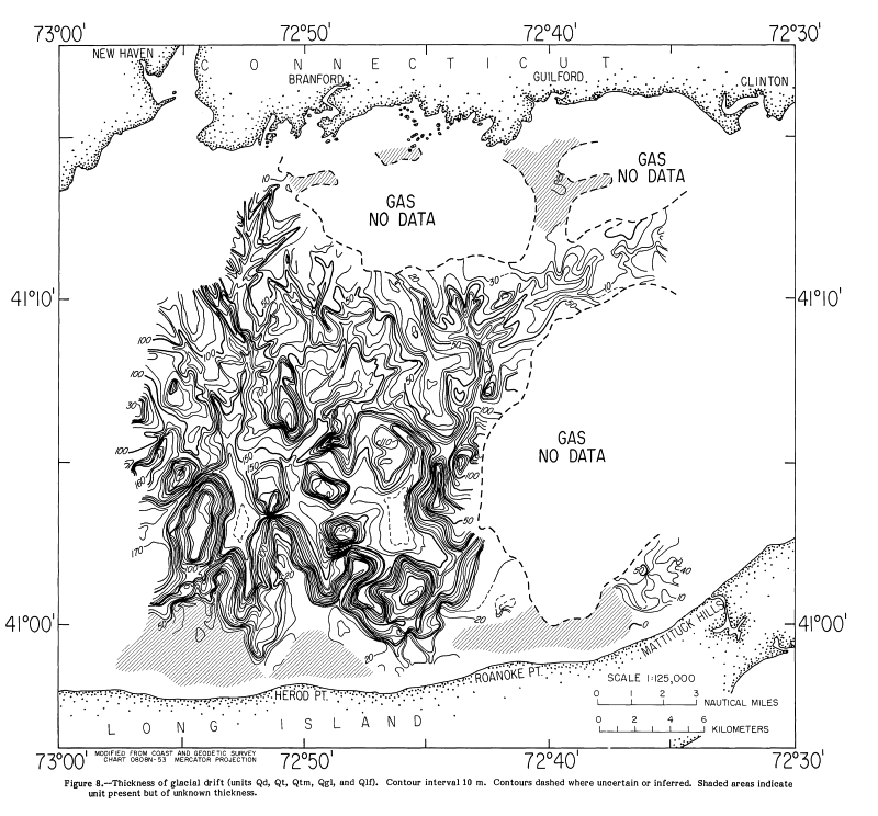
Thickness and Distribution of Glacial DriftThe glacial drift that unconformably overlies the crystalline bedrock and coastal-plain strata is present in almost all of east-central Long Island Sound. The aggregate thickness of the drift is as much as 180 m
(Figure 8). The end-moraine deposits (Qtm) are offshore extensions of end moraines that occur along the northern shore of Long Island (Figure 9). These deposits are as much as 40 m thick. Till (Qt) as much as 40 m thick is scattered across the Sound and generally overlies interfluves and the upper walls of valleys cut in bedrock and coastal-plain strata. Till preferentially occurs in areas less than about 130 m below sea level (Figure 9). In two locations near the Connecticut shore, till is exposed at the sea floor, and in one location near Long Island, end-moraine deposits are exposed (Figure 5). Some deposits mapped as till, especially near the Connecticut coast, may be part of small end moraines whose morphology is not known well enough to identify as morainal. Flint and Gebert (1976) reported offshore extensions of the Madison and Old Saybrook moraines in the areas underlain by gassy sediments south of Branford and Guilford. Alternatively, some of the till may form drumlins, especially near the Connecticut coast.
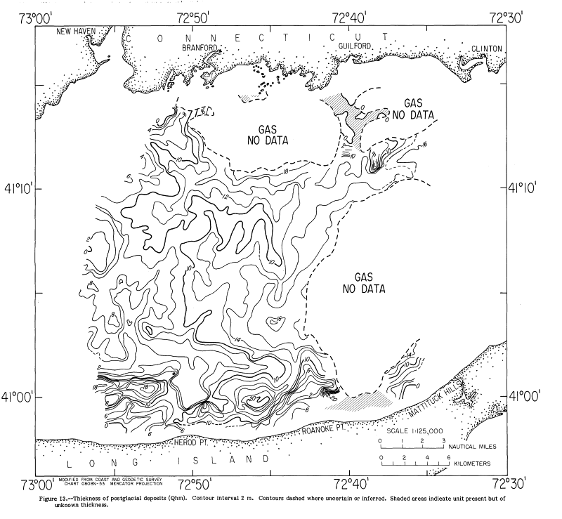
Depth to the Marine UnconformityThe surface of the glacial deposits (Figure 12) is primarily a wave-cut feature formed during the postglacial marine transgression. This marine unconformity (urn) generally cuts the glacial drift, most commonly the upper lacustrine and fluvial deposits. To the extent that the upper lacustrine and fluvial deposits represent glacial conditions,
Figure 12 The marine unconformity is preserved beneath a cover of Holocene marine sediments throughout most of the study area. Only in some near-shore locations are Holocene marine sediments absent so that glacial sediments are exposed (Figure 5) and the marine unconformity forms the sea floor. The wave-cut surface is relatively smooth, but several aspects of its morphology appear to be expressions of pre-existing topography. In the northern two-thirds of the study area, the marine unconformity deepens from northwest to southeast, from Branford, Conn. toward Roanoke Point on Long Island. The rough outlines of several underlying bedrock and coastal-plain interfluves are preserved in the wave-cut surface, despite glacial deposition and cutting of the marine unconformity in this area. In the southern third of the study area, the wave-cut surface deepens more steeply away from the Long Island coast, and it mimics the shape of the underlying moraine. North of Roanoke Point, the underlying coastal-plain divide is clearly reflected in the shape of the marine unconformity. Thickness and Distribution of Postglacial DepositsThe postglacial sediments comprise fluvial and estuarine sediments that were deposited prior to and during the
The Holocene marine sediments (unit Qhm) make up most of the postglacial deposits and are by far the most extensive. They cover almost all of study area (Figure 5) and they are as much as 20 m thick (Figure 13). The thickness of the postglacial sediment appears to correlate with the morphology of the wave-cut surface of the glacial drift (Figure 12): Holocene marine deposits are thickest over lows in the drift surface and thinnest over highs. Late Cenozoic Geologic HistoryDuring Tertiary to early Pleistocene time, streams eroded valleys in crystalline bedrock and coastal-plain strata in the area of present Long Island Sound. Fluvial erosion could only have occurred in this area during times when sea level was considerably lower than at present; several such times have been suggested locally (Flint, 1963) or globally (Vail and others, 1977). The location of Tertiary drainage was probably influenced by pre-Late Cretaceous bedrock valleys inland of the overlap of Cretaceous deposits (Flint, 1963; McMaster and Ashraf, 1973). Much of the morphology of the preglacial fluvial system is preserved in the prominent unconformity atop the bedrock and coastal-plain strata. West of Roanoke Point on Long Island, streams flowing south from Connecticut and north from Long Island joined a west-flowing trunk stream that headed on the Roanoke Point-Branford divide. This divide separated the well-defined west-flowing trunk stream from southeast- or east-flowing drainage, whose detailed configuration is obscured by gas-charged sediments. The Roanoke Point- Branford divide is a prominent morphologic feature that precludes previous suggestions of a major through-flowing drainage (either eastward or westward) in Long Island Sound (Dana, 1890; Veatch, 1906; Fuller, 1914; Grim and others, 1970; Williams, 1981). During the Pleistocene, glaciers advanced across the Sound at least two times, and possibly more (Sirkin, 1982). Glaciers modified the pre-existing fluvial topography by over-deepening some of the north-south tributaries and making them more U-shaped, and by carving closed depressions along the axis of the west-flowing trunk stream west of the Roanoke Point-Branford divide. In general, however, the fluvial character of the erosion surface is clearly preserved, indicating that glacial modification of the surface was not severe. Rather than glaciers carving the lowland in Long Island Sound, the pre-existing fluvial topography may have strongly influenced the flow of the ice, as has been suggested to the east (O'Hara, 1981). During the late Wisconsinan the last of the glaciers crossed the Sound and advanced across Long Island, reaching its terminal position, which is marked by a series of end moraines that lie across north-central Long Island and continue to the east on Block Island, Martha's Vineyard, and Nantucket Island. As it retreated, this ice also formed an inner series of end moraines extending from western Long Island to Cape Cod. The Roanoke Point Moraine (Sirkin, 1982) is a segment of this inner belt of end moraines; it lies along the north shore of Long Island, and portions of this moraine extend into the Sound in the study area (Figure 9). As a result of the ice advances, subaerial and subaqueous drift was deposited in the Sound. Outwash and ice-contact stratified drift was deposited on valley floors and walls in some places. Drift composed mostly of till was deposited atop interfluves and upper valley walls of the bedrock and coastal-plain valleys in much of the east-central Sound. Some of both the till and outwash probably predate the last ice. As the ice continued to retreat, meltwater trapped between the ice and the end moraines formed lakes that eventually coalesced to form one large glacial lake that probably extended throughout Long Island Sound. Thick deposits of glaciolacustrine silt and clay (Qgl) were deposited throughout the lake. These lake-bottom deposits were subsequently covered by coarser lacustrine, deltaic, and fluvial sediments (Qlf), possibly carried to the Sound by major outwash streams. The outlets of the glacial lake are not known, but the lake may have been continuous with the lake in Block Island Sound, which probably drained eastward through Block Island Channel (Needell and Lewis, 1984). The fluvial character of the top of the upper lacustrine and fluvial unit (Qlf) indicates that prior to the marine transgression, at least parts of Long Island Sound were subaerially exposed. However, in contrast to areas farther east, the upper surface of the lake beds was not channeled or incised to a significant degree. Braided streams were probably migrating across an aggrading, fluvial surface. The difference between this situation and the incised channels farther east may simply be due to a greater sediment supply from sources such as the Connecticut River, resulting in aggradation rather than incision. Alternatively, the difference may be due to a shorter interval of time between the end of lake conditions and the marine transgression in east-central Long Island Sound. Shallow channels in the upper part of the lacustrine and fluvial deposits were filled with estuarine sediments as sea level rose. The uppermost fluvial and estuarine deposits and some of the older glacial drift were reworked during the transgression, and the sea floor was smoothed. Since the marine transgression, a blanket of relatively homogeneous, flat-lying marine sediments was deposited. Reworked sediment from eastern Long Island Sound (Lewis and Needell, 1987) and modern riverine contributions are the likely sources of this sediment. Modern currents are locally reworking the Holocene marine deposits. In general, Quaternary sedimentation in east-central Long Island Sound has tended to fill and smooth the pre-existing topography. All of the glacial units are thicker over the inferred pre-glacial valleys, and the deposition of each unit produced progressively less relief over the basins in which previous units were deposited. The post-glacial marine transgression further smoothed the post-glacial topography, and, except in areas of local tidal scour, Holocene marine deposition has continued the trend of filling in the bathymetric lows. Nevertheless, a muted remnant of pre-Quaternary morphology is preserved in the present bathymetry, in that the sea floor slopes more steeply northward from Long Island than it does southward from Connecticut. REFERENCESBertoni, Remo, Dowling, J.J., and Frankel, Larry, 1977, Freshwater-lake sediments beneath Block Island Sound: Geology, v. 5, p. 631-635. Dana, J.D., 1890, Long Island Sound in the Quaternary Era, with observations on the submarine Hudson River channel; American Journal of Science, v. 60, p. 426-437. de Laguna, Wallace, 1963, Geology of Brookhaven National Laboratory and vicinity, Suffolk County, New York: U.S. Geological Survey Bulletin 1156-A, 35 p. Donner, J. J., 1964, Pleistocene geology of eastern Long Island, New York: American Journal of Science, v. 262, p. 355-376. Flint, R. F., 1963, Altitude, lithology, and the fall zone in Connecticut: Journal of Geology, v. 71, p. 683-697. Flint, R. F., and Gebert, J. A., 1976, Latest Laurentide ice sheet--new evidence from southern New England: Geological Society of America Bulletin, v. 87, p. 182-188. Frankel, Larry, and Thomas, H.F., 1966, Evidence of freshwater lake deposits in Block Island Sound: Journal of Geology, v. 74, p. 240-242. Fuller, M.L., 1914, The geology of Long Island, New York: U.S. Geological Survey Professional Paper 82,231 p. Goldsmith, Richard, 1982, Recessional moraines and ice retreat in southeastern Connecticut, in Larson, G. J., and Stone, B.D., (eds.), Late Wisconsinan Glaciation of New England: Dubuque, Iowa, Kendall/Hunt, p. 61-76. Gordon, R.B., 1980, The sedimentary system of Long Island Sound: Advances in Geophysics, v. 22, p. 1-39. Grim, M.S., Drake, C.L., and Heirtzier, J.R., 1970, Subbottom study of Long Island Sound: Geological Society of America Bulletin, v. 81, p. 649-666. Hollick, A., 1893, Plant distribution as a factor in the interpretation of geological phenomena, with special reference to Long Island and vicinity: New York Academy of Science Transactions, v. 12, p. 189-202. Lewis, R.S. and Needell, S.W., 1987, Quaternary geology of eastern Long Island Sound: U.S. Geological Survey Miscellaneous Field Studies Map MF-1939-A, scale 1:125,000. McMaster, R.L., and Ashraf, Asaf, 1973, Subbottom basement drainage system of inner continental shelf off southern New England: Geological Society of America Bulletin, v. 84, p. 187-190. Mills, H. C., and Wells, P. D., 1974, Ice-shove deformation and glacial stratigraphy of Port Washington, Long Island, New York: Geological Society of America Bulletin, v. 85, p. 357-364. Munsell Color Company, 1975, Munsell soil color charts: Baltimore, Maryland. Needell, S.W., and Lewis, R.S., 1984, Geology of Block Island Sound, Rhode Island and New York: U.S. Geological Survey Miscellaneous Field Studies Map MF-1621. Newman, W.S., and Fairbridge, RW., 1960, Glacial lakes in Long Island Sound: Geological Society of America Bulletin, v. 71, p. 1936. O'Hara, C. J., and Oldale R.N., 1980, Geology and shallow structure, eastern Rhode Island Sound and Vineyard Sound, Massachusetts: U.S. Geological Survey Miscellaneous Field Studies Map MF-1186. O'Hara, C.F., 1981, Preglacial morphology of the inner continental shelf off southeastern Massachusetts and its influence on late Pleistocene glacial deposition and drift morphology: Geological Society of America Abstracts with Programs, v. 13, no.7, p. 521. Oliver, J.E., and Drake, C.L., 1951, Geophysical investigation in the emerged and submerged Atlantic Coastal Plain, Part V--The Long Island area: Geological Society of America Bulletin, v. 62, no. II, p. 1287-1296. Pierce, D.S., and Taylor, P.K., 1975, Geotechnical considerations at Shoreham Nuclear Power Station, in Wolff, M.P., (ed.), Guidebook, 47th meeting, New York State Geological Association: Hempstead, N.Y. Hofstra University, p. 157-176. Rodgers, John, 1985, Bedrock geologic map of Connecticut: Connecticut Natural Resources Schafer, J.P., and Hartshorn, J.H., 1965, The Quaternary of New England, in Wright, H.E., Jr., and Frey, D.G., (eds.), The Quaternary of the United States: Princeton, N.J., Princeton University Press, p. 113-127. Sirkin, L.A., 1971, Surficial glacial deposits and postglacial pollen stratigraphy in central Long Island, New York: Pollen et Spores, v. 13, p. 93-100. _____1976, Block Island, Rhode Island - evidence of fluctuation of the late Pleistocene ice margin:Geological Society of America Bulletin, v. 87, p. 574-580. _____1982, Wisconsinan glaciation of Long Island, New York to Block Island, Rhode Island, in Larson, G.J., and Stone, B.D., (eds.), Late Wisconsinan Glaeiation of New England: Dubuque, Iowa, Kendall/llunt, p. 35-60. Suter, Russell, de Laguna, Wallace, Perimutter, N.M., and Brashears, M.L., Jr., 1949, Mapping of geologic formations and aquifers of Long Island, New York: New York Water Power and Control Commission Bulletin GW-18, 212 p. Tagg, A.R., and Uchupi, Elazar, 1967, Subsurface morphology of Long Island Sound, Block Island Sound, Rhode Island Sound, and Buzzards Bay, in Geological Survey Research 1967: U.S. Geological Survey Professional Paper 575 C, p. C92-C96. Tuttle, C.R., Alien, W.B., and Hahn, G.W., 1961, A seismic record of Mesozoic rocks on Block Island, Rhode Island: U.S. Geological Survey Professional Paper 424-C, p. C254-C256. U.S. Department of Commerce, 1967, Bathymetric map of Long Island Sound: Coast and Geodetic Survey chart 0808N-53, Mercator Projection, scale 1:125,000. Vail, P.R., Mitchum, P.M., Jr., Thompson, Sä III, Todd, R.G., Sangree, J.B., Widmier, J.M., Bubb, J.N., and Hatlelid, W.G., 1977, Seismic stratigraphy and global changes in sea level, in Payton, C.E., (ed.), Stratigraphic interpretation of seismic data: American Association of Petroleum Geologists Memoir 26. Veatch, A.C., 1906, Underground water resources of Long Island, New York: U.S. Geological Survey Professional Paper 44, p. 19-32. Williams, S.J., 1981, Sand resources and geological character of Long Island Sound: Coastal Engineering Resource Center, U.S. Army Corps of Engineers, Fort Belvoir, Virginia, Technical Paper No. 81-3. |
||||||

|