U.S. Geological Survey Open-File Report 2007-1366
Sidescan-Sonar Imagery and Surficial Geologic Interpretations of the Sea Floor in Central Rhode Island Sound
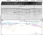
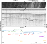
The bathymetric highs in the study area are composed of glacial till and have surficial features including sand waves and erosional benches and scarps. The central channel in our study area was probably once part of a southerly and southwesterly flowing glacial drainage network (McMaster and Ashraf, 1973). The channel's sea floor is generally lacking bedforms, but has many trawl marks. Evidence of fresh water lakes is found in the sounds and bays near Rhode Island Sound. A system of lakes that once stretched eastward from Long Island Sound through Block Island Sound, Rhode Island Sound, Narragansett Bay and Buzzards Bay left varved deposits 80-150 m thick in Long Island Sound (Lewis and DiGiacomo-Cohen, 2000). Clay concretions on the sea floor and laminated sediments up to 160 m thick are evidence of freshwater lakes that were scattered throughout Block Island Sound during a period between 19 ka and 14 ka; the lakes eventually coalesced into one lake covering about 650 km² (Bertoni and others, 1977; Needell and Lewis, 1985). Like the nearby sounds and bays, stratified sediments in the study area, which are up to 30 m thick and cover much of the northern, western, and southeastern parts of the study area, are evidence for the presence of these freshwater lakes. Tiger-striped backscatter patterns, which we interpreted to be sand waves, are located across much of the northern and southeastern part of the study area. Knebel and others (1982) interpreted backscatter patterns of patches and lineations in their sidescan-sonar data from these areas to be reworked sediments; however, they were unsure of whether erosion, deposition, or a combination of the two was responsible for these patterns. We infer that the sand waves are formed in environments characterized by coarse-grained bedload transport. In Knebel and other's (1982) sidescan-sonar imagery, coarser grained patches had areas of megaripples with wavelengths up to 1.2 m, which are visible in our sonar data and have wavelengths as great as several meters. Erosional benches notched into the regional bathymetric slope occur at depths of 30-36 m in the study area and are interpreted to represent paleoshorelines. The hills, scarps, and level areas that characterize these features tend to occur linearly across southward-facing slopes at a consistent range of depths. Areas of higher backscatter along the line of benches tend to have megaripples on the surface. The benches tend to occur in glaciolacustrine sediment at or near contacts with the subaerial erosion surface or the till (figs. 7 and 8). In Long Island Sound, steps in Pleistocene glacial drift and Cretaceous sediments along with lens-shaped seismic units and broad terraces at depths including 30 m and 37-38 m have been interpreted to be paleoshorelines (Gayes and Bokuniewicz, 1991). Closer to our study area, but at shallower depths, a submerged barrier spit off Block Island was inferred to represent a paleoshoreline with a depth of 24.5 m (McMaster and Garrison, 1967). The benches and scarps in our study area are thought to have formed around 9-10 ka based on a sea-level-rise curve for southeastern Massachusetts (Oldale and O'Hara, 1980). |