
Test Case 2
Estuary

|
|
This test case provides a fundamental check of the ability of a model to represent 1) mixing processes typical of estuarine conditions, 2) resuspension, advection, and deposition for suspended-sediment transport, 3) temporal dynamics of upper bed layer, and 4) interaction of suspended-sediment and the bed.
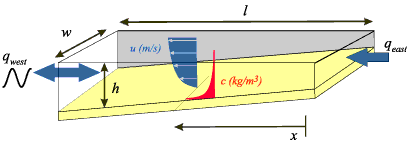
DomainThe domain is a long, narrow rectangular channel. Bottom SedimentSingle grain size on bottom: ForcingNo Coriolis Initial ConditionsSalinity distribution from west end = 35 to east end = 0 Boundary ConditionsNorth and south sides = walls with no fluxes, no friction Flow, Eastern end, constant riverine (varying depth)qeast = 400 m³ /s Output (ASCII files suitable for plotting)At t = 10 days (20 tidal cycles): Physical ConstantsGravitational acceleration g = 9.81 m/s² NoteIf a model incorporates physical constants that differ from these, and/or automatically calculates some values specified here, please specify the values used. ResultsSolution to Test Case 2: Estuary
|
These pages are for communication among a group of researchers studying experimental methods of modeling and visualizing natural systems using digital (numerical) techniques. The methods and models discussed are in preliminary, developmental, stages and may be incorrect. The pages will be changed or removed without warning. The U.S. Geological Survey makes no representation as to the accuracy, correctness, or utility of any data, model, model results, or technique associated with these pages.
Skip Navigation

 U.S. Department of the Interior |
U.S. Geological Survey
U.S. Department of the Interior |
U.S. Geological Survey
URL: woodshole.er.usgs.gov/project-pages/sediment-transport/Test_Case_2.htm
Page Contact Information: WHSC Webmaster
This page last modified on Monday, 05-Dec-2016 16:31:20 EST