|
|
|
| Coastal and Marine Geology Program | |
| Woods Hole Science Center | |
![]() U.S. Geological Survey
Open-File Report 2005-1018
U.S. Geological Survey
Open-File Report 2005-1018
Surficial Geologic Interpretation and Sidescan Sonar Imagery of the Sea Floor in
West-Central Long Island Sound
BATHYMETRY DISCUSSION
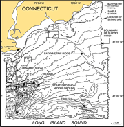
Bathymetry within the survey H11044 area is influenced by the geological framework and modern current regime. Most of the study area sea floor slopes gently to the southeast or south; however, more complex bathymetry consisting of shoals, lesser bathymetric highs, and troughs are present in the western, southern, and northeastern parts of the study area (DiGiacomo-Cohen and others, 1998). Water depths in the study area range from 3 m near the Connecticut coastline to over 50 m in troughs. Two shoal complexes, Stratford Shoal Middle Ground and a less-pronounced unnamed shoal south of Lordship, Connecticut, make up the west-central and northwestern parts of the study area, respectively. Stratford Shoal rises over 20 m from the surrounding sea floor. The shoal off Lordship and northern parts of Stratford Shoal are composed of glaciolacustrine deltaic sediments, while southern parts of Stratford Shoal are probably composed of coastal-plain deposits (Lewis and DiGiacomo-Cohen, 2000). The shoals are separated by an east-west trending axial trough, which is the deepest feature in the study area, with water depths reaching 52 m. The northeastern corner of the mosaic contains a northwest-southeast trending elongate bathymetric high, which is about 2-6 m in height, 1.5 km wide, and extends for a length of 11 km within the study area. This bathymetric ridge is composed of ice-proximal glaciolacustrine fan deposits (Lewis and Stone, 1991). The southeastern corner of the study area contains two isolated bathymetric highs, probably cored by coastal plain deposits (Lewis and DiGiacomo-Cohen, 2000), rising about 5 m above the surrounding sea floor. An east-west trending trough reaching depths of 45 m cuts between the two highs. The south-central section of the study area contains a small, elongate basin with an east-west trend and a slightly steeper gradient. |
![]()