Skip USGS links group
USGS - science for a changing world
NOAA logo with link to NOAA home page

Woods Hole Science Center

End of USGS links group
U.S. Geological Survey Data Series 99, Version 1.0

A GIS Library of Multibeam Data for Massachusetts Bay and the Stellwagen Bank National Marine Sanctuary, Offshore of Boston, Massachusetts, USGS DS 99; Version 1.0
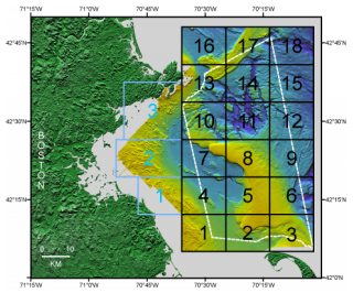
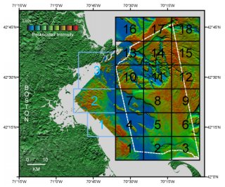

Skip navigational side bar

Introduction

The U.S. Geological Survey (USGS) has mapped the sea floor of the Stellwagen Bank National Marine Sanctuary and western Massachusetts Bay, offshore of Boston, Massachusetts (figure 1a, figure 1b). The mapping was carried out using a Simrad Subsea EM1000 Multibeam Echo Sounder (95 kHz) on the Frederick G. Creed on four cruises between 1994 and 1998. The mapping was conducted in cooperation with the National Oceanic and Atmospheric Administration (NOAA) and with support from the Canadian Hydrographic Service and the University of New Brunswick. This GIS Library contains images and grids of bathymetry, shaded relief bathymetry, and backscatter intensity data from these surveys in an Environmental Systems Research Institute (http://www.esri.com) (ESRI) ArcMap 9.1 Geographic Information System (GIS) project. The shapefiles, images, grids and associated metadata may also be downloaded individually. Descriptions and interpretations of the data are available in a series of published maps.

Figure 1a.  Boundaries of Stellwagen Bank and western Massachusetts Bay map series quadrangles superimposed on shaded relief topography.

Figure 1a. Boundaries of Stellwagen Bank (1-18 in black) and western Massachusetts Bay (1-3 in blue) map series quadrangles superimposed on shaded relief topography. The boundary of the Stellwagen Bank National Marine Sanctuary is shown in white.
Figure 1b.  Boundaries of Stellwagen Bank and western Massachusetts Bay map series superimposed on backscatter intensity over shaded relief topography.

Figure 1b. Boundaries of Stellwagen Bank (1-18 in black) and western Massachusetts Bay (1-3 in blue) map series superimposed on backscatter intensity over shaded relief topography colored by backscatter intensity. The boundary of the Stellwagen Bank National Marine Sanctuary is shown in white.


Jump to top of page
Return to Title Page. Go on to Published Maps.

Any use of trade names is for descriptive purposes only and does not imply endorsement by the U.S. Government.


Skip Navigation

Accessibility FOIA Privacy Policies and Notices

U.S. Department of the Interior | U.S. Geological Survey | Coastal and Marine Geology

URL: cmgds.marine.usgs.gov/publications/ds-99/webpages/intro.html
Page Contact Information: CMGDS Team
Page Last Modified: Wednesday, 06-Dec-2017 11:27:13 EST