Woods Hole Science Center
Sea-Floor Character and Sedimentary Processes of Great Round Shoal Channel, Offshore Massachusetts
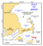
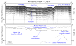
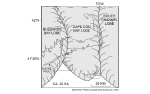
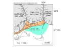
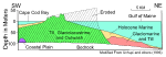
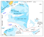
Bedrock beneath the study area, which is presumably composed of crystalline Paleozoic rocks and consolidated sedimentary and weathered igneous rocks of mid-Mesozoic age (Oldale, 1969; Folger and others, 1978; Hallett and others, 2004), forms a surface that lies 240-350 m below sea level and dips progressively toward the southeast (Oldale and others, 1973; O'Hara and Oldale, 1987). The bedrock is unconformably overlain by strata with a slightly irregular surface incised by numerous north-south valleys that have been interpreted to be coastal plain deposits of Upper Cretaceous to Tertiary age (fig. 2; Folger and others, 1978; Hall and others, 1980). The Cretaceous deposits are predominantly micaceous sand and silty kaolinitic clay; the Tertiary deposits are variably glauconitic sand. Much of the younger surficial geology of southeastern Massachusetts is a product of glacial processes during the late Wisconsinan part of the Pleistocene Epoch and a storm and tidally dominated marine regime during the Holocene sea-level rise. The late Wisconsinan Laurentide ice sheet reached its maximum extent and southernmost position about 20 ka, as marked by terminal moraines on Martha's Vineyard and Nantucket and the southern limit of abundant gravel on the adjacent sea floor (Schlee and Pratt, 1970; Uchupi and others, 1996; fig. 3). This lobate ice front was formed by the Buzzards Bay lobe that deposited the moraine along the western part of Martha's Vineyard, the Cape Cod Bay lobe that deposited the moraines across eastern Martha's Vineyard and Nantucket, and the South Channel lobe that extended east toward Georges Bank (Oldale and Barlow, 1986; Oldale, 2001). Subsequently, the continental ice sheet receded northward, but the rate of the lobes' retreat varied. Deposits associated with the Buzzards Bay lobe are oldest; deposits associated with the Great South Channel lobe are youngest (Oldale and O'Hara, 1984; Oldale, 2001). Shortly prior to 18 ka, the ice sheet had retreated and the Buzzards Bay lobe occupied a position northwest of the Elizabeth Islands, the Cape Cod Bay lobe a position along the northern edge of Cape Cod, and the Great South Channel lobe to the east of the Cape Cod Bay lobe (fig. 4; Larson, 1982; Uchupi and others, 1996). About this time the main part of Cape Cod was deposited as a delta, the Barnstable outwash plain, in a glacial lake that occupied Nantucket Sound. Although not differentiated beneath the study area, the northward retreat of the ice front across Glacial Lake Nantucket Sound left deposits of glacial drift characterized by 1) a strong upper reflector and numerous irregular, discontinuous, parabolic internal echoes, thought to represent till; 2) flat lying to gently dipping reflectors, thought to represent outwash and ice-contact stratified deposits; and 3) well layered rhythmic sequences, thought to record glaciolacustrine deposits (fig. 2; O'Hara and Oldale, 1987). Just after 18 ka, continued retreat of the ice fronts positioned the Buzzards Bay lobe northwest of Buzzards Bay, the Cape Cod Bay lobe in the center of Cape Cod Bay, and the Great South Channel lobe northward and eastward, creating an intervening low between itself and the Cape Cod Bay lobe (Uchupi and others, 1996; fig. 5). As the Cape Cod Bay lobe retreated, meltwaters dammed to the south by the Sandwich moraine on Cape Cod and to the east by the Great South Channel lobe formed a proglacial lake, Glacial Lake Cape Cod Bay (Larson, 1982; Oldale, 2001; Smith and Ashley, 1985). Sediments transported by meltwater streams flowing westward and southwestward into this lake from the South Channel lobe created three large deltas that, in order of age, constitute the Wellfleet, Truro, and Eastham outwash plains (Masterson, 2004). Coarser grained deposits within these deltas primarily record higher energy proximal environments and probably represent topset beds; finer grained deposits within these deltas primarily record lower energy distal environments and probably represent bottomset beds. The deposits of drift are capped by a major unconformity formed by subaerial exposure during the post-glacial lowstand of sea level and the subsequent Holocene marine transgression. This transgression has also conspicuously modified the outer Cape and produced the present-day physiography of the study area (fig. 2). Prior to 6 ka, massive erosion of the east side of Cape Cod produced sediment that filled in a depression at the elbow of the Cape. Because Georges Bank was still exposed, it partially blocked long-period waves from the east and southeast, but not northeast, resulting in net sediment transport toward the south (Ziegler and others, 1964; Ziegler and others, 1965). After Georges Bank was finally submerged about 6 ka, waves were no longer blocked, northward sediment transport became more pronounced and the construction of the Provincetown Hook began (Ziegler and others, 1965; Uchupi and others, 1996). Since the Holocene transgression began, much of the deltaic sediment that constitutes the outer Cape has been eroded (fig. 6). Uchupi and others (1996) estimate that the original eastward facing scarp was up to 7.0 km farther east than the modern shoreline, and present-day east-facing bluffs formed by the outwash plains are retreating at rates that in places exceed 2 m/yr (Strahler, 1988; Oldale, 2001). Remaining outwash deposits, which presumably overlie basal till, are 125-150 m thick (Oldale, 1969). The modern littoral drift along the east-facing outer Cape diverges near Wellfleet. Sediment to the north is transported along the coast and is building the Provincetown Hook; sediment to the south is transported along the coast and is supplying sand to Monomoy Island and to the shoals adjacent to the study area (figs. 1 and 7; Oldale and others, 1971). Construction of the Provincetown Hook and Monomoy Island, maintenance of the shoals, and erosion of outwash plains exposed to the Atlantic Ocean continues. Great Round Shoal Channel, together with another smaller passage near the tip of Monomoy Island formed by Butler Hole and Pollock Rip Channel, provide navigable access to and from eastern Nantucket Sound (fig. 7). Great Round Shoal Channel leads east from the Sound for about 4.6 km, but subsequently trends southeast (approximately 125°) for about 7.4 km between Great Rip and Great Round Shoal to the tip of the Shoal from where it bends to the northeast (approximately 50°) and continues between Orion and McBlair Shoals. Channel width varies, but averages about 2-3 km. Strong semi-diurnal tidal currents in the channels at the eastern entrance to Nantucket Sound are driven by the different filling rates and sizes of the adjacent water bodies and the lateral constraint imposed by Monomoy Island and Great Point. Ebb tides in Great Round Shoal Channel, which flow west from the Atlantic Ocean into Nantucket Sound, exceed 1.6 kts (fig. 7; Eldridge Tide and Pilot Book, 2006). Flood tides are slightly weaker, but exceed 1.4 kts. These currents have built and maintained the shoals adjacent to the southern tip of Monomoy Island and winnowed the glacial drift that underlies the study area, locally leaving bouldery lag deposits on the sea floor. |
Click on figures for larger images.
|
![]() Title |
Introduction |
Setting |
Methods |
Overview |
Discussion |
Interpretation |
Data Catalog |
Acknowledgments |
References |
Figures |
Bottom Photographs |
Sediment Data |
Contacts
Title |
Introduction |
Setting |
Methods |
Overview |
Discussion |
Interpretation |
Data Catalog |
Acknowledgments |
References |
Figures |
Bottom Photographs |
Sediment Data |
Contacts