
Woods Hole Science Center
Sidescan-Sonar Imagery, Multibeam Bathymetry, and Surficial Geologic Interpretations of the Sea Floor in Rhode Island Sound, off Sakonnet Point, Rhode Island
![]() Title |
Introduction |
Geologic Setting |
Data Acquisition/Processing |
Bathymetry |
Sidescan-Sonar Imagery |
Environments |
Discussion |
Summary |
GIS Data Catalog |
Acknowledgments |
References |
Figures |
Contacts
Title |
Introduction |
Geologic Setting |
Data Acquisition/Processing |
Bathymetry |
Sidescan-Sonar Imagery |
Environments |
Discussion |
Summary |
GIS Data Catalog |
Acknowledgments |
References |
Figures |
Contacts
 |
||
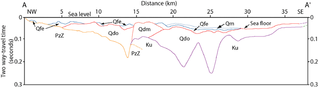
Figure 3. Interpreted stratigraphy of Rhode Island Sound from O'Hara and Oldale (1980). Acoustic units include: PzZ - Proterozoic to Paleozoic bedrock, Ku - Cretaceous coastal plain sediments, Qdo - Wisconsin glacial drift deposits, Qdm - Buzzards Bay moraine deposits, Qfe - Holocene fluvial and estuarine deposits, and Qm - Holocene quiet-water marine deposits. Boundaries are dashed where inferred. Vertical exaggeration: 40X. Location of stratigraphy profile shown as A-A' in figure 1. | ||

