|
|
Oceanographic sensors and instruments make many kinds of measurements and store their data internally in a variety of formats. The WHCMSC employs one methodology to treat data from all of the instruments, and generate BBV data (fig. 31). After recovery, the raw data from each sensor, instrument or logger are offloaded to a shore-based computer. The data are then read from the raw format, which is usually some form of compressed binary. For all instruments, metadata about the deployment are incorporated into the attributes of the data file early in the treatment sequence. These parameters include tripod ID, latitude, longitude, and water depth; instrument serial numbers and settings; sensor height above seabed; sampling rate; start and end dates; and calibrations. When configuration parameters are available from the instrument, they are also captured in the metadata. Conversion to scientific units, and data validation typically follow the addition of metadata, but may be accomplished simultaneously. Processed versions of time-series data files from all instruments are stored in EPIC-compliant NetCDF files.
The timing accuracy of all instruments is verified by comparing the times of the data transitions into and out of water to the mooring log deployment and recovery times. The number of samples should be consistent with the sampling interval and duration of the deployment. The current, hydrographic and turbidity data are validated against statistical norms and are compared to measurements from nearby instruments for consistency, when possible.
Notes on time and orientation that are common among all instrument types are discussed below, followed by documentation of the specific processing software and procedures used for each instrument type.
Most instruments used by the WHCMSC create one file containing data from the entire duration of the deployment. The sonars are the exception, where one file is created per sample for each type of sonar. Each instrument that collects data has a suite of programs used to read, assess, convert, and analyze that type of data. The following sections address how the data from each type of instrument are treated and the data format employed.
|
Click on figure for larger image. 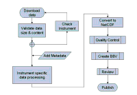
Figure 31. Diagram showing the steps in processing time-series data beginning with the initial download from an instrument and ending with publication in this database. (BBV is Best Basic Version. NetCDF is the format for all of the time-series data in this database). |
|